
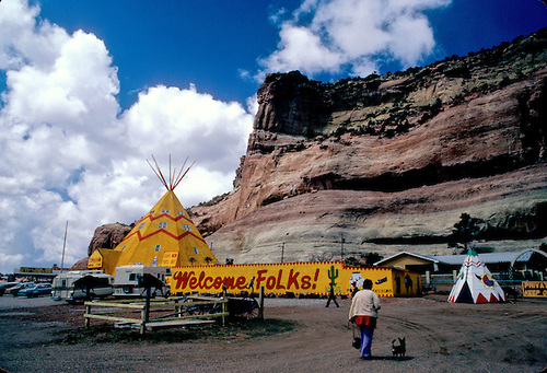
GET YOUR KICKS ON ROUTE 66 HISTORIC ROAD WEST DEFINES AMERICA REMAINS A TREASURE TO BE NURTURED AND APPRECIATED…


“THEY COME INTO ROUTE 66 FROM THE TRIBUTARY SIDE ROADS, FROM THE WAGON TRACKS AND THE RUTTED COUNTRY ROADS. ROUTE 66 IS THE MOTHER ROAD, THE ROAD OF FLIGHT” writes John Steinbeck in the “Grapes of Wrath” about the crush of humanity fleeing the dust bowl…
 on Route 66 Mortiarty New Mexico")
Over the years Archie Wilson has accumulated acres of old cars and toys in Moriarty NM.
Few people can testify to America’s Route 66 experience better than Archie Lewis.  For decades Archie has crawled over those roadways, through the nooks and crannies, in old barns and lofts collecting acres of Americana til now he runs the Lewis Antique Auto and Toy Museum off Route 66 (Interstate 40) in Moriarty, NM. His collection of cars that “made it this far and not a foot more…”, all cars that represent another way of life. The history of the automobile and transportation unfolds across Archie’s acres of scrap metal and artifacts.
 Crosley Wagon built from 1939 through 1952 a visionary car with a 4 cylinder engine capable of 30-50miles per gallon<
For some it was a world of chrome and heavy steel and for others, a world of muscle, those cars were nothing like our cars today, those cars once kicked ass. They could move in a 0-70mph world and they ruled. Restored muscle-cars fill Bono’s Route 66 Car Museum in Santa Rosa and many more restored cars from the fifties and sixties show up at other Route 66 roadsides all across the country from Chicago to California.
 Old Trucks that brought produce and goods to market along the famous Route 66 lie still baking in the hot sun. The architecture of the period, oddities like the Wig-Wam Motel in Holbrook, AZ or garages like JR’s Tires in Moriarty NM built in 1937 and are both still serving passing motorists with tires, oil changes and repairs and a place to stay.
  Still open for repairs and oil changes.
  A owner of seven or eight motels, Charles E. Lewis saw his first Wigwam Motel in Kentucky and decided that he would like to build a Wigwam Village of his own. At that time, franchises were unknown, the original motel owner Mr. Redford was more interested in sharing his plans than making money. So Lewis and Redford came to an agreement that radios would be placed in each Wigwam that would play for one half hour for a silver dime. Mr. Redford would then receive the dimes from the radios for a period of some years in payment for the use of his plans.
 There were seven of these Wigwam Villages built from the 1930’s to the 1950’s from Florida to California, this one in Holbrook, may be the best known because it is on Route 66.
U.S. Route 66 known as the Main Street of America or the Mother Road or The most famous road in the world was a highway within the U.S. Highway System Route 66 it was established on November 11, 1926. One of the original U.S. highways, Route 66 was established on November 11, 1926. Sixty-six originally ran from Chicago, Illinois, through Missouri, Kansas, Oklahoma, Texas, New Mexico, Arizona, and California, before ending at the pier in Santa Monica, California covering a total of 2,448 miles.
 Tumacori, New Mexico
The staple of life that brought Route 66 alive and to which it clings yet today, the Mother Road as John Steinbeck called it in the “Grapes of Wrath” was a pathway to opportunity.  It was an escape from the life folks knew and during the depression there was much to leave behind and California was a beacon of hope, so the towns and communities along Route 66 created an economy from interstate travel; with garages, cafes, travel-lodges, motels, dime-stores, groceries stores and roadside oddities. Any reason to stop and stretch your legs, whole communities took their identity from a single oddity or claim to fame, each town was the birthplace of every kid in town.
Code Talker Memorial in Gallup, NM in front of the Gallup Cultural Center, formerly the Santa Fe Depot, and now the historic Route 66 structure is used for community discussions and lectures. Native American dancing can be seen there nightly during summer months. Today there are websites and state-wide organizations from the eight states touched by the road who have car shows, rallies and planned weekends to celebrate each year the blessing of Route 66. Historical organizations take their hard earned funds and make donations to historic structures along the route who need cash to hold on to the history.
 Laguna Pueblo on Route 66 attracts motorists and tourist can often over run the ancient pueblo, some residents sell pottery and baked goods.
 Laguna Pueblo Church asks no pictures be taken inside the chapel. It is accepted practice to ask if a person would mind being photographed.
 Indian Roadside Village attracts tourist dollars and begs the tourist to bring their cameras whereas the Laguna Pueblo attracts lots of visitors from the highway and the constant pressure on the centuries old pueblo from outside influence is mitigated by new attractions and casinos in the area that welcome the traveler and their smartphone cameras and their business.
 Willis Motor Court in Geronimo, AZ is a good example of the early motor court with customer parking, which is disappearing everywhere like these historic structures.
  TwoGuns
Places like the Route 66 Motel in Kingman, Arizona has been serving Route 66 travelers since 1963. It’s iconic sign has been featured in National Geographic (September, 1997). Diners at the Ariston Cafe still enjoy the dining ambiance of this family-run eatery. The Chicken Basket has been serving its famous fried chicken since 1946. In historic times, the owner would flood the roof in winter and hire youth to ice skate on top of the building. The owner received more than $10,000 matching funds to repair the Route 66 Motel Sign whose towering red and yellow sign remains a beacon for travelers on dark nights and has been for more than 50 years it now will continue to serve as an important Route 66 landmark in Kingman, Az.
Local communities spruce up their connection with Route 66 or build on it like in Williams, Az there is the Cruiser Drive-In for shakes and burgers with a hot rod on the roof, Elvis Presley graces the doorway of one novelty shop and every business have Route 66 souvenirs.  >Just off I-40 Williams, Az exit (one turnoff to the Grand Canyon) is a drive-thru animal safari featuring black bears, called Bearizona, and white buffalo, several species of wolf, mountain sheep and mountain goats, south west burros and a fine raptor show.
  William’s also has the Bill Williams Wilderness and nearby lakes are a big tourist draw but all the smart money in town is invested in Route 66, the mystic and history that evolves around the road that once built it’s own TV series, had it’s own theme song and slogan: “Get your kicks on Route 66”. It is a story that repeats itself in every little town or village that was “once touched” by Route 66 over the years new alignments, bypasses, new roads have replaced the highway that once brought America together. Route 66 was born in a whirlwind love affair with the automobile, freeing us from the tracks laid down by railroads and opening the west to investigation by the masses.
  The road trip was born and the roadside attraction came shortly thereafter. “are we there yet” chorus came from the backseat and home-cooking was a big attraction and towns all across the US managed to pull in a few dollars from gas, food and lodging developing enough economy to encourage, nurture and develop the heartland of America after the Depression.

Built in Flagstaff, AZ to showcase animal heads to tourist passing on Route 66 at one time the largest log cabin in the United States.
The Museum Club built in Flagstaff, AZ by unemployed lumberjacks hired to build “the biggest log cabin in Arizona” built by a taxidermist to showcase his lifetime collection of stuffed animals, six-legged sheep, Winchester rifles, Indian artifacts, two-headed calves, and more than 30,000 other items. Operating as a museum, taxidermist shop, and a trading post, scores of Route 66’rs stopped in to visit Dean and his collection during the five years that he operated the museum. Before long, locals dubbed the museum “The Zoo.” Today the popular Flagstaff nightclub offers refreshment to weary travelers seven day a week.  After World War II a thankful America elected General Eisenhower who had seen the Autobohn in Germany during the War and knew the important role it had played in the national security of the countries of Europe, so he wanted one. For decades Main Street America fought the Interstate Highway Act but slowly and surely Route 66 was replaced by Interstate Roadways that stopped for no one, no town, nothing–toll roads had their own gas stations and convenience marts–it took time to hop off the interstate and go into town. Slowly but surely those towns on the blue highways dried up and Route 66 became more of a state of mind, a place in time, a TV Show, a period of discovery and growth, simple times that once defined America as a land of opportunity made up by hard-working individuals who had yet to meet their match…in America anything was possible !
 koU/s/500/I00009o9NnnBnkoU.jpg’ />
Starring Route 66 is an American TV series in which two young men traveled across America. Route 66 was the first TV show shot entirely on location starring Martin Milner,George Maharis  whose moodiness was later replaced by smiling Glenn Corbett. Some of today’s biggest stars launched their careers on the Route 66 TV Show. Robert Redford, Robert Duvall, James Caan, Alan Alda, Stephanie Powers, Suzanne Pleshette, Boris Karloff, Peter Lorie, Walter Matthau, Martin Sheen, Leslie Nielsen, Ronny Howard, Edward Asner, Jack Warden, Deforest Kelly, Inger Stevens, Julie Newmar, Barbara Eden and more…
In late September the InterNational Route 66 Mother Road Festival celebrated its 10th Anniversary with over a 1000 restored classic cars cruising downtown on a friday night. Seventy Thousand spectators are expected in the heart of Springfield’s Illinos historic downtown each year for a weekend of family fun, non-stop live music, entertainment,food and don’t forget friday night’s Mickey Thompson Tires BURNOUT Competition in Horsepower Alley. The prior weekend the Route 66 14th Rendezvous held each year in San Bernardino, CA celebrates the Highway and in early August MEET ME IN ST LOUIS on Route 66 celebrates for three days.
 from Seligman,AZ to Topock, AZ passing through Kingman, and the old mining town of Oatman.
ROUTE 66 BILLBOARDS CAUSE TRAVELERS TO PULL OVER AND STOP…..CLICK HERE
![]()

<a href=" SPANISH TRANSLATIONS:
TUCSON’s 2011 DAY of the DEAD PROCESSION : A NEVER-ENDING LESSON in LIFE and LOVE !


WHAT DOES THE DAY-of-the-DEAD MEAN to YOU ?
“It’s for people who have died and we are celebrating the death of them” says 7-year old Paloma Handro Sunday night at Tucson’s 2011 Day-of-the-Dead Celebration this year Paloma was thinking of her friend’s dad who died of cancer and wants to everyone to remember to “always be nice to people because you never know when they may die…”


“I’m missing my mother tonight” says Irma Lopez, “Refugio Rosales, she’s been gone for eight years now! She taught us special traditions about celebrating those who have gone ahead. “Our family would sit among the headstones, eating and drinking enjoying and remembering the music and earthly pleasures our ancestors loved and mom would tell us stories about my uncles, grandparents and father.” “It was a never-ending lesson in Life and Love!” Then she would make us promise to clean the graves each year and to celebrate our families Day of the Dead. “You have to do this!” she would say, “I won’t be here, so you have to carry on our families tradition.” This memorial takes place each year at the downtown cemetery in Agua Prieta, Sonora and tonight Irma has brought her family to the Tucson’s 2011 Day of the Dead Procession to carry on the same tradition and to build new ones. Tonight Irma, her daughters and grandchildren stand along Congress Avenue and watch hundreds of people walking-by covered with photos of loved ones, shrines so large they are mounted on wheels.


Some pay homage to friends, neighbors and relatives, even the family dog. One small terrier wore wings, each wing had a photo of puppies who had come before and left a knot in the heart.The sounds of drums and bagpipes filled 4th Avenue – along with the smells of burning incense – as the procession began.


The University of Arizona Marching Band turned out as skeletons a hundred strong, many organizations who have adopted the twenty year old event have marching groups and floats. The Tucson’s Gay alliance had a red banner maybe 200 feet long bearing the names of Aids deaths and counseled the crowd to “Be honest about your status! “Get tested! It’s the only way we will stop Aids!”

Made for Flight chronicled 116 Transgender Deaths world-wide in 2011, Humane Borders journals lives lost in the desert due to lame immigration laws and others marched to “Kill Hate”. On the walls of building, slide shows of beloved family pictures, past and present each representing someones remembrance…!


This year’s grand finale was held west of the Santa Cruz in the Rio Neuvo construction site featuring a 75′ crane that lifted the giant urn onto position and took the man-sized fire ants aloft. This year the crowd easily moved about and while vision from the viewing area was still limited it was safer, fewer flaming embers and the huge 20,000 person crowd disappeared without incident.
FOR MORE PHOTOS VISIT THE GALLERIES OF SOUTHWESTPHOTOBANK.COM>
 Entry way for spectators to enter the performance arena west of downtown.

Tucson's Day of the Dead Celebration held at the end of the 2 mile march

Day of the Dead Celebration lights up and fills fills the air with smoke and drama

The torched Urn sends aloft the prayers from Tucson well-wishers.

FlamChen Fire Ants Ignite the Urn full of Tucson Hopes, Dreams and Prayers
FOR A MULTIPLE-MEDIA SLIDE SHOW
OF THE TUCSON DAY OF THE DEAD PROCESSION
![]()
<a href=" SPANISH TRANSLATIONS:
BEARIZONA! ENTER at YOUR OWN RISK! South West BLACK BEAR Preserve Productive Stop for Photographer

-

- Red-Tailed Hawk swoops in over spectators heads during a discussion about the Hawk’s ability to sneak up on its prey–like rabbitts.
 BISON
BISON BIGHORN SHEEP
 HUNTING OWL

“Keep your windows rolled Up” they remind me as I pull away from the beautifully carved BEARIZONA front entrance and pass the work crews attacking one wall with metal screen and stucco. With mud flying in all directions, rolling up my window afforded protection from both bears and flying construction material. When it comes to making pictures of creatures native to North America, forty species can be seen at Bearizona, that makes it a great find, a real diamond in the rough. A work in progress situated on a beautiful 160 acres outside of Williams, AZ on a Interstate 40 off-ramp about an hour south of the Grand Canyon, the wild animal “safari-style” drive through is the only place where my Sheltie “Chester” in the backseat serves as bait for my next subject to draw them in closer. Once my front wheels break the first electric barrier, I know I am on foreign soil, the sign says DATHL SHEEP but I don’t see anything. 
Busting the second barrier things change fast. “BUFFALO!” one large Brown Bison ranging about a 300mm lense off in heavy shadow but moving about, trying to be picturesque. The third barrier, I drop the telephoto and move to the wide angle lens as the action quickened with Lobos — I had a canine on board and they knew it.  The White Timber wolves sniffed out my Sheltie and swarming my Xterra seemed to agree it had potential. The Mountain Sheep were cute and their feeder was situated next to the 3 mile drive (Breakfast is dished up between 9am-10am bringing the critters close to the road) that allows cars to pull right off I-40 and drive through a wild animal preserve featuring Bears, Buffalo, Bobcats, babies, Lobos, Mountain Sheep and Raptors. At the end of the drive-through there is a walk through which allows folks to get out to see Raccoons, Bobcat, Lynx, the fab four Bear Cubs plus hibernation caves and the amazing Raptor Show.

Since many of the 12 bear come from different climes, their hibernation cycles vary, bears from Minnesota get sleepy in November while South West natives might stay up later, into December. 
The Park closes during January and February and opens March first when the bears start wandering out for something to eat in early Spring. Driving through the Bear enclosure visitors are told to roll up their windows and to drive away if a bear approaches their car. Usually the bears sleep, roll around and some pace back and forth in the sunshine. Few paid much attention to the vehicles rolling through their enclosure. Drivers are warned in case of car problems, to stay inside the car, turn on their emergency flashers and honk the horn. Never get out of the Vehicle. Help will arrive! Cameras cover the whole drive and park and reviews say help arrives fast. Fort Bearizona is the old west log fort design in a semi-completed state, the drive through is about 70% complete hopes include a future Elk enclosure soon and since the Grizzly Bear and Mountain Lion “are far too dangerous for the drive-through” the walk-through area is only 35% of the final plan which calls for Grizzly Bear, Mountain Lions and Armadillos enclosures with a restaurant, an expanded gift shop, and a 800 room hotel.
The Park this spring birthed it’s first Bear Cub and named it “Doc” after Doc Casey, father of Sean and Dennis Casey, owners and operators of Bearizona. The brothers have entertained more than 100,000 visitors since their “soft” opening May 2010 and have spent a reported $15M to get the park off the ground, new animals arrive as their enclosures are completed.  Bearizona Raptor Show engages the spectator.
 Spectators at Raptor Show
The Casey family developed the original Bearizona USA which today is the 4th largest tourist attraction in South Dakota second only to Mount Rushmore and the Black Hills–the brothers hope to duplicate that success “out in the wild west” and to build green using solar and water recovery, reuse and not to mention access to all that traffic headed to the Grand Canyon. The Park provides the perfect opportunity to see many of the wonderful creatures that wander the trails of North America and a place to get out stretch your legs and look around. I rather liked the flute player but some folks are less tolerant ! Everyone likes the four bear cubs in the kindergarten, two are rescues and two were born at Bearizona. Those big, beautiful bisons, Irma, Yankee, Doodle, Dandy ! Are all beautiful and standouts and worth the drive without the bears….they move in and out of the shadows close to the road, their size force me to use a wide angle to include their entire 1200 pounds! Bearizona has built shallow animal enclosures that keep the creatures close to the road with greater access for photographers half of the inmates are rescues and half are from private institutes like zoos or preserves, so most have seen people before and have a level of domestication and enjoy posing.

 BISON AUTUMN
For a keeper’s view at Bearizona Arizona Daily Sun’s Betsy Bruner gets up close with bears /
GETTING THERE
Location: Williams AZ, Bearizona has easy access located just south of I-40 at Highway 64 (Historic Route 66)
Only 58 miles to the South Rim of the Grand Canyon and 25 miles west of Flagstaff, 216 miles southeast of Las Vegas
Directions: Take U.S. Highway 93 south for 103.8 miles. Merge onto Interstate 40 via the ramp on the left toward Flagstaff/Phoenix and travel 112 miles. Take Exit 165 (Williams/Grand Canyon). Go south for 0.25 miles. Bearizona is immediately on the left.
General information: Bearizona, (928) 635-2289, bearizona.com.
Visitors should allow one to two hours for their Bearizona adventure.
Hours: Open daily at 8 a.m. from March 1 through Dec. 31.
Closing time varies based on daylight hours. Park may close because of inclement weather.
Visitor rates: $16; $15 for seniors; $8 for children ages 4 to 12
Free for children 3 and younger. Season passes are $125.

FOR MORE WILDLIFE PHOTOS CLICK HERE FOR SOUTHWEST WILD LIFE.
![]()
<a href=" SPANISH TRANSLATIONS:

AMISH FALL ENDS MID-MISSOURI SEASONAL CYCLE HARD WORK BEGINS ANEW BEFORE THE SNOW FLYS


After the hottest summer in recent memory the Mid-Missouri Amish are now getting ready for winter and playing a little. After sleeping on the front porch for much of July and August these Old Order Amish have taken most the field corn from the fields and are finding time, to socialize, finish home projects and to spend some hard earn profits on next years enterprises.


 Eyeballing the Texas Range Cattle
  Texas cattle is flooding into the Midwest, range cattle is being trucked out of the frying pan called Texas where droughts and huge grass fires have reduced their feed and ability to survive. Amish farmers expect to spend more this winter to feed their adoptees and hope to double their investment from the butcher in March. Meanwhile Edward Yoder’s mother-in-law is moving in to help her daughter Millie, 34, with her eight kids and Edward is building a new store where Amish and English both will shop and enjoy the home baked goods and low salvage prices typical of Amish stores spread throughout the large community of maybe 200 Amish families.

 New Floor for the store.
 The Clark Missouri numbering more than 2000 souls, makes it the largest Old Order community in the United States and likely the strictest anywhere, except for a small sect of 200 in Orange County Indiana who can’t buy anything scanned with a bar code. Meanwhile another 50 new families have started up farms here near Clark, Missouri perhaps another 15-20 have joined up with Amish from Wisconsin and Iowa to create news colonies in Macon, Keytesville, LaPlata and Gibbs where they plan to farm, and grow new communities where they can escape some of their main colonies hardships and at the same time find good and cheaper farmland where their kids can buy land next door and grow old with mom and dad. Outside Macon Missouri at Ten Mile Corner, one new group allows their number to wear stocking caps and use snow guards on their buggies and to work in town every day, if they can find the work. The Clark Colony which started up slowly in the 1950’s is very prosperous and thriving.
  When kids reach the age of 17, on friday night all Amish youth gather somewhere to socialize and find someone to grow old together. Soon however there will be too many to fit in any room in the colony and they will have to divide them up in districts much like they do with schools and the colonies’ ten church districts. The community has grown prosperous from their produce and crafts auction which is getting bigger and bigger every year and the sawmills, lumberyards, metal and carriage shops have all the work they can handle.
  Quilts Sales at the 9th annual Craft Auction
 Squash and Gourds are big sellers this time of the year.
 Still individuals busy themselves in the slower winter months making rugs, Amish dolls and quilts, cedar lawn furniture and made-to-order cabinets and fine furniture. In recent years, giant igloo cooler buildings have been built, so in winter, pond ice can sawed and stacked and then that cools perishables all summer long.
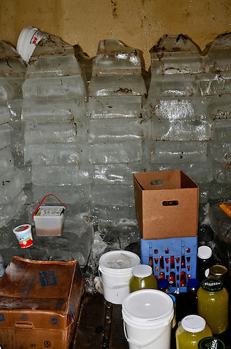 This September view of last winter pond ice
 My favorite is the home-baked banana or wheat bread found in many of the farmhouse-based bakeries, like the saddle, clock or basket shops where seasonal produce like sweet corn, tomatos, onions and now pumpkin and squash can be purchased.
  Saddle and Harness Shop
  But the Tuesday and Friday produce sales, bring in English now by the droves to buy for themselves or nearby restaurants who cater to the organic market. Milk prices have been a godsend, many Amish have struggled with prices near $7.50 and some almost quit, before this fall’s prices tumbled down to $20 giving the whole community of dairy cows a new lease on life. Clark Amish have for a long time been hooked up with the milk industry, and have more than twenty refrigerated milk stations where they drop their milk so large trucks can pick it up and drive it out for sale. The cost and utilities of the milk stations is deducted from their profits but ownership belongs to outsiders. Still new convenience sneak-in, phone shacks have been added around the community who shun cars, pickups and tractors so the Amish can call out in emergency or lineup a ride to town, too far for a quick trip in a horse-drawn buggy.
 I recently attended an Amish auction where a 100 year old McCormick and Deering Combine sold for $5500. The Amish auctioneer noted that “this combine had many more years of use and was just getting broke in”, a real steal for someone.
 In addition to window frames, steel wheels, gates, levelers (for horse teams), canvas, buggy horses sold for $1450 down to $950, they had a grab bag.
 Two fine black and white heifers, had spent 30 days in the same pasture with a prize bull and as the auctioneer pointed out, it was highly likely a calf could greet the lucky buyer this spring–but who could say for sure. Those heifers brought almost a $1000, with the possibility of a two for one purchase.
  Personally, I was impressed by the pies, cakes and cobbler covered with homemade ice cream that the women folk had worked hard to sell and auction off to the several hundred Amish who came to shop and socialize.
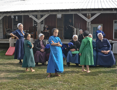

IF YOU GO: The weekly produce auction is found from Columbia by taking Highway 63 North 20 miles to Highway 22 East (Collier’s Junction), then two miles to Highway Y North, continue on Highway Y approximately six miles to Auction on right. Cash is preferred.
src=’http://cdn.c.photoshelter.com/img-get/I00002vDaXZchTRo/s/500/I00002vDaXZchTRo.jpg’ />Reading the Morning Mail CLICK HERE FOR THE HISTORY OF AMISH IN THE UNITED STATES AND THE WEB PAGE MID-MISSOURI AMISH: PROMISED LAND
SOUTHWESTPHOTOBANK AMISH GALLERIES CLICK HERE FOR MORE PICTURES
![]()
<a href=" SPANISH TRANSLATIONS:
URANIUM MINING in the SOUTH WEST: NAVAJOS TRAPPED BY TAILING and DECADES OF INACTION


RARE METALS AZ URANIUM PROCESSING FACILITY
RARE METALS AZ Processing facility was one of the four mills that victimized the NAVAJO during the COLD WAR, creating an AMERICAN TRAGEDY; says Henry Waxman D-CA who points to a history of neglect that would not be tolerated elsewhere. Among the horrors: shifting mountains of uranium tailing; open mines leaching contaminated rain into drinking water tables; wind-blown radioactive dust; home construction from uranium mine slabs; and even the grim spectacle of children playing in radioactive swimming holes.
 <
<
 Nez Bancroft with her hogan where she lived all her life watching the white dust blowing around the Valley
( WHITE DUST PART TWO )
When Uranium prices started to rise in 2006 folks on the Arizona Strip and in Fredonia, Utah started to smell jobs. Rural desolation and the depression has starved the economic opportunities here, “Does Fredonia even have a motel anymore” Carol Tinney asks herself, continuing, “When Salazar stopped Uranium Mining he stopped those jobs, and broke those folks hearts.” As far as Kanab Creek (being radioactive) “There is so little water in that stream, there’s hardly enough to worry about”, she adds about the drainage that worries Steve Martin because he’s concerned about the ecosystems down stream and believes everything will suffer from toxic heavy metal and radiation.
“I worry about uranium escaping into the local water, and about its effect on fish in the Colorado River at the bottom of the gorge, and on the bald eagles, California condors and bighorn sheep that depend on the Canyon’s seeps and springs. More than a third of the Canyon’s species would be affected if water quality suffered” — Steve Martin, former Grand Canyon National Park Superintendent
Secretary Salazar this summer was joined at the Mather Point Amphitheater in Grand Canyon National Park by BLM Director Bob Abbey, National Park Service Director Jon Jarvis, and US Geological Survey Director Marcia McNutt.
Secretary of the Interior Ken Salazar on JUNE 20, 2011 said the Grand Canyon must be guided by “caution, wisdom, and science,” so as to protect the World Heritage Site, tribal interests, drinking water supplies, and the tourism economy that the area’s natural resources support. In Salazar remarks he stated that he would take action to close one million acres of public and National Forest System lands surrounding the Grand Canyon to new uranium mining and claims.
On Jul 24, 2011 – Arizona Congressman Jeff Flake put a rider on the Interior Department’s appropriations bill to tie the Interior secretary’s hands.”Uranium mining outside of Grand Canyon National Park can create jobs and stimulate the economy in northern Arizona without jeopardizing the splendor and natural beauty within the park,” the congressman said in a statement posted on his website. “That’s why the proposed moratorium on new uranium claims is opposed by state and local officials in Arizona.”Rep. Flake’s comments about Arizona opposition to the moratorium is not exactly accurate.
Officials for the Central Arizona Project, which provides water to nearly 80 percent of Arizona’s 6.5 million residents, have expressed concern over uranium mining around the park in a joint letter cosigned by the Metropolitan Water District of Southern California and the Southern Nevada Water Authority. A number of sportsmen groups oppose mining on the lands and multiple local and national sportsmen organizations sent a letter to Secretary Ken Salazar thanking him for upholding the temporary moratorium on new uranium mining claims, and requested that he extend the ban to 20 year.
“Wildlife, fisheries and the water that supports us are not partisan issues,” the group letter states. “Uranium mining near Grand Canyon National Park is wholly unacceptable given the best science available and the potential impacts not only to our natural resources but to the economy of Northern Arizona and the communities that drink Colorado River water.”

Today, the NPS advises hikers against “drinking and bathing” in the Little Colorado River, Kanab Creek, and other Grand Canyon waters where “excessive radio nuclides” have been found. Although it is difficult to attribute this contamination to any specific activity, there can be little doubt that the cumulative effects of mining, milling, and transporting radioactive materials are causing long-term, adverse effects on people, water and other resource values in the Grand Canyon region.
The legislature may rule on this rider and closure before the August recess ?
Earlier this summer, Navajo President Joe Shelly proclaimed Uranium Legacy Remembrance Action Day and led a march to United Nuclear Corp, a Church Rock New Mexico Uranium Mill that was the scene of the largest low-level radioactive waste spill in U.S. History. On July 16, 1979, 94 million gallons of acidic waste water spilled into the Puerco River, a tributary of the Little Colorado River traveling 50 miles downstream before settling in the Arizona stream bed after an earth-tailing dam failed. Shelly’s proclamation commemorated the 32nd anniversary of the Church Rock Tailing Spill as well as six decades of Uranium impact on the Navajo reservation.
The demand for Uranium–on Navajo lands and has poisoned the scarce waters as well as taken many lives and the health of the Navajo people becoming the biggest sacrifice ever visited on a people. Ed Singer, Cameron Chapter President
“They don’t mine like that anymore!” say Carol Tinney, who believes the jobs, Uranium mining will bring the Arizona Strip will far outweigh the ecological concerns for downstream which are over stated and are fears fueled by boogieman stories of the past and out-dated mining processes. The Navajo Nation, which encompasses large chunks of Arizona, New Mexico, Colorado and Utah disagrees they say they are living proof of the after affects of Uranium Mining and suffer daily from the old mining processes and the inaction of the government, and the mining companies who walked away from their responsibilities leaving piles of white dust to blow where ever the wind took it.
 NEZ BANCROFT FAMILY outside their Hogan
 View of the sacred San Franciscan Peaks
White dust-like powder blowing daily across Rare Metals couldn’t be poison Navajo elders say at the chapter house in Tuba City—look at Nez Bancroft she lived there 65 years going on a hundred, they laugh.
But Nez Bancroft is not laughing. Rare Metals is now an abandoned uranium tailing located five miles north of Tuba City on the Navajo Nation but once it was Bancroft’s pasture where thirty years ago as a girl, she herded sheep and later as a mother she raised her children and watched the bulldozers come to her pastures pushed her sheep aside and began mining the soil. She remembers the funny smell of uranium that always followed them while tending livestock, her throat would soon parch and ached while tending the sheep, the powder was everywhere, for twenty years she and her family covered their mouth and face when riding through their valley.
Before the tailing mined closed in 1976, Nez Bancroft moved her extended family of twenty plus children and grandchildren from their birth site up wind from the tailing and contaminated pools. Most suffer from mysterious eyesores and like their grandmother Nez, they at times, aches from head to toe, and their doctors can find no cause or treatment. The hillside view in the late 1970’s overlooked the sacred peaks above Flagstaff and what was left of Rare Metals, a smelter building and foundations of company town homes on the south side of Navajo Route 160 and maybe a dozen homes still standing on the north side.
 Navajo Sheep Grazing in the exposed Uranium tailing long abandon by Rare Metals Corporation. Nez noted she saw twenty of her sheep drink from standing pools near the tailing and they soon died. Fencing today protects livestock from the contaminated water but suspect wells were used in those days especially during droughts. No one told them not to use the wells then, but today the ground water in the area has a plume of contamination and while that water is not used or needed today, all the inhabitants have been moved off the land but what happens in hard times.
From her hillside hogan for more of a decade, Nez Bancroft has watched winds carry the white powder “like a busted flour sack” into the homes built for the whites brought in to harvest and smelt the rare metal and who left as soon as the jobs played out. During the Bennett Freeze in the 1970’s-80’s, those abandoned homes, served as stop gap housing for Navajos who couldn’t live anywhere else.
 Betty Dodd and puppies who ran free and wandered home covered in white dust.
“Does it affect this side of the highway”, asks Betty Dodd about the uranium. Dodd and her 16-year-old son Dale moved to Rare Metals almost three years ago because they needed an inexpensive place to live. Rising rents had forced her from her trailer after losing her kitchen job at the High School, in Tuba City where jobs were few and far between. On this day she eats on money made selling Indian Jewelry to tourists at the traffic circle in Tuba City.
Across the tree-lined path, Bobby Marks, a janitor at the Tuba High School, a year earlier moved his family of nine into two of the remaining 10 structures north of the uranium tailing. His salary was less than $6 an hour and he couldn’t afford to drive back and forth from his Hogan and trailer at Red Lake, 20 miles away, each night after work. Like many in Rare Metals he fears for the health of his family, but has no other way to house or feed his family.
 Bobby Marks’ family
 Processing Facility next to worker homes abandoned when the mill closed and inhabited by Navajo unable to find better housing.
In 1976, the same year Ford, Bacon, Davis, Utah Inc., the primary contractor for Rare Metals shut down the mine. Betty Dodd applied for benefits from the Navajo-Hopi Relocation Commission in Flagstaff. Dodd was born “right on the line” of the Bennett Freeze “on the building or remodeling of any homes in the disputed land”. Born in the Coal Mine Mesa District of the Navajo-Hopi joint use district she was told it was mandatory she apply and was told she “would hear from them within three months”, they promised. They promised a letter with instructions would arrive and that was 10 years ago she says, throwing another log on the wood fire. In April she went to Flagstaff and the Commission said come back in July after the deadline for relocation, saying they had no idea what money and land would be made available.
“Find me a house, then I’ll move”, Dodd said. “They want me to move to New Mexico, near Roswell”, she says, “I’ll go anywhere”, “I won’t complain but I’d rather be here.” Sick, off and on all last winter, Dodd relies on her brothers and sisters in Tuba City whose children haul wood and water helping out when Dodd often frequently feels too dizzy to trip into town. The potbelly stove glows in the dark house, outside the wind whips around the structure as the sun drops out of the sky. The burning wood warms the living room, the lack of electricity makes little difference to Dodd who rises with the sun and her dogs, Rocky and Lobo, she prefers to stay away from radios, TV’s and town.
“Rare Metals, isn’t the only place you can die of cancer,” she says. “besides, I like it here. It’s so quiet and peaceful.”  Dodd’s sons deliver water from Tuba city for washing and drinking.
Across the tree-lined path a neighbor James Peshlakai feels differently, fours years ago when the Navajo Tribe took control of the property he moved his four children into their free house at Rare Metals. Today he’s bitter, “whoever processed the uranium knew the danger of walking away from it” when we moved here, we knew of no danger.” “Now I can’t move, can’t build—the Hopi won’t allow any new development… this land is frozen.”
The polticans just talk about it, the Navajo Tribe, the Hopis, the Federal Government, the Department of Health “we’re the scapegoats”. “I don’t like it!” says Peshlakai. “I have a truckload of cinder block, another of building material bought and paid for in Flagstaff—just waiting. I asked to move to Cameron or Tuba City, they say. “It’s frozen. In Tuba City all I hear,it’s frozen” “Meanwhile everyone here is frozen here”, he concludes….
 James Peshlakai Family
 WINDBLOWN MAP 1981 STUDY
From 1984 through 1995, the Department of Energy spent $240 million to cover tailing piles at the old uranium mills as part of a nationwide program. Tailing are the fine sand left over when ore is ground up to extract uranium. They retain most of the radioactivity and give off large quantities of radon, an odorless, cancer-causing gas. A 1981 Engineering assessment of the Rare Metals 800,000 tons of uranium tailing for the Department of Energy found that “trucks could remove material from the site at a rate of at least of 2,000 tons a day, removing all tailing and contaminated materials within two years. But since Blanding, Utah was the nearest functioning mill, it was decided “the costs of removal would far exceed the value of the uranium that could be recovered from the tailing”.

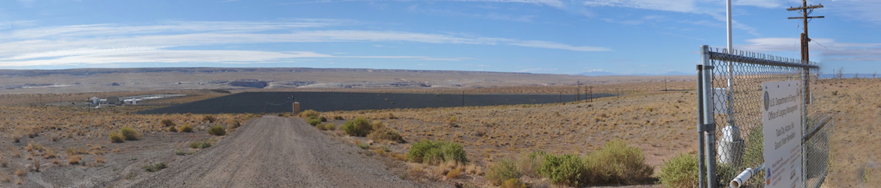
When completed in 1990, the Super Fund Cap in Rare Metals covered about 50 acres. Nearly 2.3 million tons of contaminated materials are entombed in the cell and, according to the DOE fact sheet, the cell contains “all of the residual radioactive materials at the mill site, the contaminated windblown materials from surrounding properties, and debris from the demolished buildings.” RARE METALS Arizona is a Uranium mill company town, these foundations were finally bulldozed and removed, so was the topsoil, inches of it scrapped up and trucked away. From June 1956 to November 1966, the Tuba City Rare Metals Mill processed 796,489 tons of uranium ore. The U.S. Department of Energy says, when the mill closed three connected mill tailing piles containing 800,000 tons of material and three evaporation ponds remained. The mill became a Superfund site, all that is left of the Mill today is a fenced remediation site. For decades Navajos lived in homes left abandon after the mill closed, some buildings were torn down and the material reused elsewhere. A Remedial Cap (below) was placed on Rare Metals Tailing in the 1990’s, forty years late.
In the summer of 2014 North Arizona Researchers have developed a hypothesis that if uranium is photoactivated by UV radiation it could be more harmful to skin than either exposure alone,” said Diane Stearns, professor of biochemistry who with co-author Janice Wilson, developed a study that that once uranium was present on the skin, exposure to UV radiation or sunlight could be chemically toxic and lead to cancerous lesions. The team members now has recommended that future risk assessments regarding cancer caused by uranium exposure include the possibility of photoactivation in skin.
RARE METALS AZ – Images by P.K. Weis
DESERTSUNEditorial: Step cautiously with uranium PRO & CON
Uranium Poisons the Soil……Arizona Republic
![]()
<a href=” SPANISH TRANSLATIONS:">
PECOS CONFERENCE OPENS WINDOW TO THE VIRGIN ANASAZI’S ARIZONA STRIP FARMERS AND TIMELINE…

 DOUG McFADDEN leads archaeologists on a tour of a few of the 100 ground features he discovered on the KANE RANCH which claims a big portion of the ARIZONA STRIP.
The VIRGIN ANASAZI are a mystery, in the big World view, there is Chaco Canyon in Northwest New Mexico as the apex of the Anasazi Culture featuring large great houses like Pueblo Bonito, the crown jewel, which was representative of the finest in Pueblo construction. Next comes the Mesa Verde Anasazi who built large cities in the defensive caves of southwest Colorado, like Cliff Palace. Then we have the Kayenta Anasazi of northwestern, Arizona, who are seen as the country cousins. Along the Arizona Strip blending into South Western Utah we find another group THE VIRGIN, similar in Anasazi material culture to the Kayenta, but different in architecture and layout and a ceramic tradition that varied from their kissing cousins the Kayenta Anasazi both in construction and style. It’s controversial and what folks disagree on, differs, but some believe the Kayenta and Virgin are the same. Others wonder to themselves, “Did the Virgin influence the Kayenta?” or just the opposite as everyone else believes!
 BLACK MESA BLACK and WHITE, a rare KAYENTA ceramic found on the VIRGIN site compounds the question who influenced who, the KAYENTA people whose material culture is predominant just ten miles to the east or the VIRGIN tradition which extends north into Nevada?
I’m touring a Virgin farming community with Utah Archaeologist Doug McFadden who has studied this parcel of the Kane Ranch off and on over 20 years and he has found lots of sign that these farmers were masters of their own world and not influenced by the outside world, “There’s no farming in the Kanab area”, says McFadden who has found about a 100 sites where these farmers have constructed field houses, wind breaks, check dams, drainage terraces, storage bins and one huge row house. “That’s what makes this pretty exciting”! “This wasn’t happening anyplace else!” Still more unique for these farmers he believes everyone stored their surplus here so they could help out others with shortages. There is little pottery on the site so McFadden thinks the pit house occupation was short and perhaps unsuccessful he believes the Kane Ranch area was farmed during the late Pueblo II period or 1100-1150 AD. Archaeologist Helen J. Fairley, who wrote the book: The prehistory and aboriginal history of the Arizona Strip, differs by saying the site might date as early as 1050 and she points out the two trails leading off the Vermillion Cliffs and the Paria Plateau that allowed prehistoric man to farm the basins below and try to control rainfall and irrigate the land.
 ARCHAEOLOGISTS point out the trails leading to the top of the KAIBAB PLATEAU allowing seasonal visits from prehistoric man and later allowed cowboys to push cattle on top during the summer and back to the valley floor during the winter months. Saddle Mountain (top photo above man pointing) provided pathways down to the Colorado River
 This seasonal double strategy allowed man to follow his game and sprinkle some seed in the lowlands in early spring and seed again in the uplands in the late spring. McFadden wondered why there where so many field houses until he spent a day in a lightning storm and found how exposed one could be there and it would help to get out of the sun or wind while farming when not home. Drought finally got these folks, pushed them toward the drainage and water. Forced to hunt for more food, they might have run into competition with the Southern Paiute or other hunter/gather nomad groups, and warfare or raiding groups may have forced migration and aggregation into larger groups. So much is not understood and in fact little study has taken place in the Arizona Strip Regions, even less has been published or agreed on. Early independent studies in the Strip and Southern Utah raised interest but archaeologist working in isolation in remotes sites found it important to collaborate with other southwest archaeologist working elsewhere and to compare notes and soon the Virgin cultures was found along the Virgin River in Southern Nevada and its expansion questioned whether the Virgin did influence the Kayenta and posed many research questions.
 AUGUST 2011 PECOS CONFERENCE was held south of Jacob Lake on forest land near the North Rim of the Grand Canyon….
The Pecos Conference, first proposed in 1927, by Alfred Kidder started out as twenty archaeologist sitting in chair around a pine tree. Each year since archaeologist leave the field in early August and meet up in a cool spot with hundreds of other southwest archaeologist, students, teachers, vocational archaeologist and delivery papers, chat up people about other sites, talk about terminology and try get everyone on the same page. The work of the conference might condense the best of everyone’s work on a specific topic and generate the latest Bible for folks to follow, this generates politics and factions…but a bluegrass band and beer truck and BBQ can frequently take care of any hard feelings about a culture dead and gone by 1200 AD…
 TEMPER makes the real difference in determining whether a ceramic is from the Kayenta or Virgin tradition, temper is the glue that holds the clay together, and the Virgins broke up sandstone full of crystals and the Kayenta didn’t…
 Some of the 350 2011 Pecos participants are given opportunity to view the differences between tempers.
No one really noticed the archaeology of this region until they started to talk of placing a dam across Glen Canyon and creating Lake Powell or flooding Lake Mead, everything done since has been one step ahead of the bulldozers or water. In 2005 Stewardship of the 850,000 acres by the Grand Canyon Trust began with the purchase of the Kane and Two Mile ranch allotments. Those ranches sharing a 110 mile border with the northern edge of Grand Canyon National Park, the ranches extend over most of the Kaibab Plateau from Kanab Creek to the west and down the rolling eastern monocline as the Plateau transitions into the Marble Platform. The ranches continue east across the House Rock Valley to Lees Ferry and northward across the entire Paria Plateau and into Paria Canyon, virtually touching the Grand Staircase Escalante National Monument at its northernmost reaches. We tour the Kane Ranch turn-of-the-century Ranch house, completely redone inside, sandstone walls and steps, beautiful conference table and a log cabin out house which has been replaced by a totally solar bathroom over the hill.
 KANE RANCH historic ranch 850,000 acres are managed by the Grand Canyon Trust
Wild Bill Hickok stopped at the Kane Ranch to resupply and drink his fill and he moved on along the massive Vermillion Cliffs where today many transplanted Condor have spread their wings to restore the regions biodiversity. Fishermen flock to Lee Ferry for fishing and beer (huge selection, great cheeseburgers) and the wifi hotspot, tourists stop for lunch, check email, gas-up and move on for the North Rim of the Grand Canyon.

The Anasazi (“Ancient Ones”), thought to be ancestors of the modern Pueblo Indians, inhabited the Four Corners country of southern Utah, southwestern Colorado, northwestern New Mexico, and northern Arizona from about A.D. 200 to A.D. 1300, leaving a heavy accumulation of house remains and debris. Recent research has traced the Anasazi to the “archaic” peoples who practiced a wandering, hunting, and food-gathering life-style from about 6000 B.C. until some of them began to develop into the distinctive Anasazi culture in the last millennium B.C. During the last two centuries B.C., the people began to supplement their food gathering with maize horticulture. By A.D. 1200 horticulture had assumed a significant role in the economy.
Because their culture changed continually (and not always gradually), PECOS researchers have divided the occupation into periods, each with its characteristic complex of settlement and artifact styles. Since 1927 the most widely accepted nomenclature has been the “Pecos Classification,” which is generally applicable to the whole Anasazi Southwest. Although originally intended to represent a series of developmental stages, rather than periods, the Pecos Classification has come to be used as a period sequence:
Basketmaker I: pre-1000 B.C. (an obsolete synonym for Archaic)
Basketmaker II: c. 1000 B.C. to A.D. 450
Basketmaker III: c. A.D. 450 to 750
Pueblo I: c. A.D. 750 to 900
Pueblo II: c. A.D. 900 to 1150
Pueblo III: c. A.D. 1150 to 1300
Pueblo IV: c. A.D. 1300 to 1600
Pueblo V: c. A.D. 1600 to present (historic Pueblo)
SOUTHWEST POTTERY JOURNAL
MUSEUM OF NORTHERN ARIZONA

SHOVELBUM.ORG, do you have talent with a shovel-can you dig? Do you have a desire to see what’s in the next shovel?

 PECOS papers covered test studies made along the Colorado River inside the Grand Canyon, Petroglyph studies of Sandal Designs and temper differences between VIRGIN ceramics and the KAYENTA ceramics that can look very much the same but have fundamental differences.
 EVERY FIFTH YEAR for more than 75 years the PECOS Conference is held at the PECOS PUEBLO north of Santa Fe, New Mexico, it is scheduled there for 2012. There is a 1213 proposal for Flagstaff and a 1214 proposal for PRESCOTT, but money is tight and sponsors are few and far between. New sponsors should be sought-perhaps in Utah, Colorado or New Mexico.
2012 PECOS CONFERENCE AUGUST 9-12, 2012 at PECOS NATIONAL PARK 30 EAST OF SANTA FE NEW MEXICO
DIRECTIONS TO THE 2012 PECOS CONFERENCE AUGUST 2012….CLICK HERE FOR MAPS
![]()
<a href=" SPANISH TRANSLATIONS:
URANIUM MINING in the SOUTH WEST: A LEGACY THAT POISONS THE LAND … AND ” IT WILL NEVER GO AWAY’!

“The U.S. Department Of Energy created a demand for uranium–the Navajo lands and scarce waters as well as the lives and health of the Navajo people became the biggest sacrifice ever visited on a people.”
Ed Singer, Cameron Chapter President, Western Navajo Nation
( WHITE DUST PART ONE )
RARE METALS Arizona a uranium mill company town, these foundations were finally bulldozed and removed, so was the topsoil, inches of it scrapped up and trucked away. From June 1956 to November 1966, the Tuba City Rare Metals Mill processed 796,489 tons of uranium ore. According to the U.S. Department of Energy, when the mill closed three connected mill tailing piles containing some 800,000 tons of material and three evaporation ponds remained. The mill became a Superfund site, all that is left of the Rare Metals Mill today is a fenced remediation site. For decades Navajo lived in these homes after the mill closed or the torn down buildings were reused elsewhere.Navajo Sheep Grazing in the exposed Uranium tailing long abandon by Rare Metals Corporation. Remedial Cap below is finally placed at Rare Metals Tailing in the 1990’s, forty years later.
Much of the debate over Uranium is disputed–the argument often pits the Navajo Tribe against mine owners who argue the Tribes religious concerns for the land vs the jobs, salaries that mining brings to a vast wasteland for any economic opportunity. The Navajo people need to be able to feed and house their families has been long exploited by corporations seeking to do business on the reservation. Uranium ore can be found anywhere. It is 40 times more common than silver and 500 times more common than gold but hard to find in concentrations rich enough to take it from the soil.
BBC video of workers underground in a Uranium mine …
Mines sprung up all over the Navajo Reservations during the 1950-60-70’s, some opened, closed, some were forgotten and as the ebb and flow of the mining business, mining operations failed, closed and they walked away from their open sore on the land. “Contaminated Buildings Abandoned on the Reservation are repurposed and utilized are Health Risks”
Since 2006 prices for Uranium ore has been climbing and now the mines are back and they want to take more Uranium from the land and the South West Tribes oppose these advances to pick up where the mines left off. The Legacy of Uranium in Northern Arizona is three Superfund Clean Ups, two in Tuba City, the Rare Metals Mill and the AEC Ore Buying Station (stockpiled uranium ore from other sites for processing) and the Monument Valley Mill site, the New Mexico Tumor Registry is providing information on clusters of cancers, many premature deaths of Uranium Miners many with lung cancers and still decades of study and little action. Beginning in the 1940s and driven by the government’s pursuit of atomic weaponry, more than 1,000 uranium mines were opened throughout the Navajo Nation. Navajo miners and millers were not told of the dangers of working with the uranium or of the simple measures that might have minimized their exposure to radiation. That fact is repeated over and over again by the miners, one who spoke with an air tube, died a few months after his video testimony.
 RARE METALS CORPORATION WALKED AWAY FROM THIS MILL AND THESE HOMES contaminated by decades of blowing white dust from the mill and the nearby Atomic Energy Commission tailing, comprised of ore dug elsewhere and trucked in for milling.
Navajo graduate students are studying links between incidents of birth defects in families and the proximity of those families to uranium mine tailing, New Mexico State Tumor Registry data from the late 1970s shows a 17-fold increase in childhood reproductive cancers compared to the U.S. as a whole. These extremely rare cancers are related to hormone systems. Another study looking at registry data from 1970-1982 showed a 2.5-fold increase in these cancers among all Native Americans in New Mexico, many Indians in northern New Mexico are Navajo.
In the mid-1990’s remediation began and the uranium tailing which sat blowing in the wind beside Navajo Rt. 160 for decades was capped and water studies begun. Plumes have been detected and they have stopped just short Moenkopi, two Hopi villages just east of the Navajo community of Tuba City.  MOENKOPI, is two villages, Upper Moenkopi and Lower
 Today residents go to four water tapes for their drinking water. Their wells may any day soon become compromised by the decades of rain leaching over exposed uranium tailing at Rare Metals, Arizona, once a mill for all the mines in the area, today lies capped but it’s legacy is already on the move. The results from shallow groundwater monitoring have identified elevated levels of contaminants near the site, among them: uranium, arsenic, chloride, lead, chromium, strontium, vanadium, and gross alpha and beta activity.
Radioactive Uranium leaks have been tracked getting closer to groundwater that provides drinking water for the two Hopi villages. Studies conducted by HOPI consultants and the Navajo Nation show uranium contamination within 100 feet of water supply wells that provide all the drinking water to the village of Lower Moenkopi. In addition, contamination is within 2,000 feet of the water supply spring that provides all the drinking water to the village of Upper Moenkopi.
Uranium has been detected in Grand Canyon streams at concentrations up to eight times greater than the drinking water standard of 30 micrograms per liter, so the National Park Service no longer recommends that folks bathe or swim in the Colorado River or off shoots of Kanab Creek and concern grow for the fish and for down stream people who drink from the flow…like all the South West: Salt Lake City, Phoenix, Las Vegas, Los Angles, Tucson and Mexico.
<a href=”http://www.grandcanyontrust.org/grand-canyon/uranium_issues.php” title=”RADIATION IN THE GRAND CANYON”>“There should be some places that you just do not mine. Uranium is a special concern because it is both a toxic heavy metal and a source of radiation. I worry about uranium escaping into the local water, and about its effect on fish in the Colorado River at the bottom of the gorge, and on the bald eagles, California condors and bighorn sheep that depend on the Canyon’s seeps and springs. More than a third of the Canyon’s species would be affected if water quality suffered.”
— Steve Martin, former Grand Canyon National Park Superintendent
refhttp://www.grandcanyontrust.org/grand-canyon/uranium_issues.php
Navajo grassroots documentary multi-media studies clutter utube today, gathering more videos all the time, there is a three part study that shows the transition from uranium ore, to yellow cake, to bombs in Iraq and how today three in 10 US Soldiers have unacceptable levels of radiation from uranium enriched bombs used in Iraq. One part of the studies say 100,000 Iraqis will die of cancers. The Grand Canyon Trust says “in 1979, an earthen dam breached, releasing 1,100 tons of radioactive mill wastes and 90 million gallons of contaminated water into a tributary of the Little Colorado River. The Nuclear Regulatory Commission acknowledges that many additional toxic tailing have been washed into our region’s waterways. Collectively, these events correlate with documented risks and harm to people’s health.”

“The first wave of uranium development resulted in dozens of claims and mines to be located in and around the Grand Canyon. In 1984, a flash flood washed tons of high-grade uranium ore from Hack Canyon Mine into Kanab Creek, which drains into Grand Canyon. Located within the Park’s south rim, the Orphan Mine continues to contaminate creeks, prompting the National Park Service to warn backpackers along the Tonto Trail not to use water from the two drainage.” The reason, experts and advocates say, lies high above where the Orphan Mine produced 4.3 million pounds of some of the purest uranium ever found in the U.S. before closing in 1969. The U.S. EPA has declared the mine a Superfund site, the NPS is said to be studying the level of contamination.
Navajos do have a younger population and relatively more young Navajo women get breast cancer than other groups. So the anecdotal evidence for doctors working on the reservation is often disturbing. “When we see women in their 30s with breast cancer, it really knocks everyone for a loop,” says physician Tom Drouhard, who has practiced in Tuba City, Arizona 30 years. “Our ladies come in with later stages and higher death rates. It’s hard to say what the trends are. All of these tumors are multifactorial, and uranium could be another thing thrown at it. We are very paranoid about the situation with uranium. We had uncovered tailing five miles from Tuba City for 20 years. It’s a reasonable concern. Charles Wiggins says, director of the NM Tumor Registry. He plans to re-examine childhood cancer statistics using data gathered since 1982.
“The DOE created a demand for uranium to feed the U.S. Cold War strategy,” said Ed Singer, president of the Cameron Chapter, one of the Navajo Nation’s Western Agency chapters.
“The Navajo people are to this very day paying for that with their health and lives. Large areas of Navajo land and scarce waters upon it as well as the lives and health of the Navajo people became the biggest sacrifice ever visited on a people.”
In the summer of 2014 North Arizona Researchers have developed a hypothesis that if uranium is photoactivated by UV radiation it could be more harmful to skin than either exposure alone,” said Diane Stearns, professor of biochemistry who with co-author Janice Wilson, developed a study that that once uranium was present on the skin, exposure to UV radiation or sunlight could be chemically toxic and lead to cancerous lesions. The team members now has recommended that future risk assessments regarding cancer caused by uranium exposure include the possibility of photoactivation in skin.
“They’ve tried to clean up the water table for years, they can’t do it. It can’t be done!”
Navajo President Joe Shirley Jr. explains why the NAVAJO people and other leaders of the HOPI and HAVASUPAI Tribes say NO to Uranium mining.”NO, WE JUST DON’T WANT IT ANY WHERE ON NAVAJO LAND!” SHIRLEY said.
RARE METALS AZ – Images by P.K. Weis
ARIZONA REPUBLIC URANIUM STUDY ….CLICK HERE
![]()
<a href=” SPANISH TRANSLATIONS:">
EXPLORING NEPAL : A SEARCH FOR PREHISTORIC MAN IN THE TIMELESS HINDU KINGDOM

 Farmer’s wife works in the field while husband plows the field and baby sits.
 Himalayas
 Rhino cross the Karnali River in Western Nepal at first light of day…
 Girl in the Mustard Seed is a celebration of color, I looked for this the whole trip and when I saw this color I knew I had finally arrived

 This child foragers for feed for the animals, building supplies and sleeping mats.
At the turn of the century, 1999 I went to explore Nepal for a month looking for prehistoric man, circ. 1500 A.D. Life in Nepal for many is a day to day event, in the village each morning folks walk a little further than the day before to gather wood, foliage or water. The land is denuded in places, trees without limbs and cold. People work all day so they can survive another. In Nepal, life is not distracted by possessions, but a Polaroid camera’s instant image was priceless because it allowed the villager to freeze-frame time for a new child, soon-to-be teenager, a rarity indeed and great Karma! Still my search for Prehistoric man took many turns as we weaved through the Himalayan Kingdom starting out in Kathmandu going east to Chitwan Animal Park where we rode elephants in search of the elusive Tiger.  Tiger Hunt in Nepal
 Highest point in the world.
From there we went North toward Everest (above) and Base Camp and we camped within sight of the world highest perch, sleeping cold at near 9000 feet from there the trip turned toward TIBET, or the Freedom Bridge which is the now border of Communist China, in the distance you could see the hillside city of Lhasa, home of the exiled Dali Llama. There is a lot of geothermic energy warming the water there and that could be the best place in Nepal for a shower including Kathmandu. Many village homes along the ancient Silk Road from India to China were mostly sticks and foliage without chimney and smoke escaped through the leaves. In colder climes, I glimpsed prehistoric life when in our trail we found common housing, sharing walls and living in multi-levels, resembling the pueblos of the American South West
  Not unlike pictures of ZUNI Pueblo in New Mexico.
and I came closer one day when I walked past a house next to the stream where a man was pounding grain with a rock to reduce it to flour. Ancient man found that practice useful, but the rock deposited in the meal, eventually reduced the teeth of the eater so they could only eat the mush anyway. I think my best view of prehistoric times, was one morning we awoke next to a stream, fog hung to the hills, and a fisherman in his dugout canoe moved skillfully around the stream checking his traps. Nepalese fisherman checks his traps early morning. While there were many wonderful scenes of the Himalayan Range but life became basic the further one hiked from roads, that became more apparent as we walked into Annapurna Conservation Area where there were no roads, anything that went there either walked or was carried by someone.
 Women on Annapurna Trail

My favorite scene was the straight chair tied to the back of a son who carried his mother down the rocky and uneven trail. Large pack trains of burros and mules each carrying large tins of kerosene to be burned for heat and light, a great luxury, where it was going. We hiked in a couple days before finally reaching a small village before turning back toward the road, my group with a dozen participates was cared for by 5 camp boys and 16 Sherpa or bearers. During the night one of the camp boys would stay awake and provide security for the group with his vigilance and his Gurka knife. It was not infrequent that a tent was sliced and something stolen and occasionally someone attacked, but seldom. In the village, I awoke with the sun and started walking about when I ran into two small kids who adopted me immediately, taking me home and insisting I go into this basement room of their home which was pitch dark, I couldn’t see anything but as my eyes adjusted I was able to figure out it was some sort of ceremonial area with figures on the walls but I could see no detail. So in the old film days when I mounted my flash and fired that shutter I created a picture I was unable to see until I got home.
 Buddist Shrine was the ceremonial room for the family elders. Further encounters in the village was mostly school kids getting ready to run off to school and parents working to get them off. Everyone was curious and friendly, as I moved past the school and into the downtown of shoppes, I wondered about the uniforms all the school kids wore and later was told that the uniform levels the playing field for all kids rich or poor. English is the second national language of Nepal, so all the school kids are delighted to practice on you.
 Road crews in western Nepal.
 Budda’s Path to Enchantment began here.
As the expedition grew closer to India, the terrain grew flatter, and a short distance from the Indian-Nepal border we stopped at a large archaeology site where a young man named Siddhartha Gautama, who later became Buddha, was born in 623 B.C. in the famous gardens of Lumbini he began his Path toward Enchantment. A suburb of Kathmandu, Dunbar Square, which was built 1000 years ago, and still stands in spite of pesky earthquakes that have leveled other regions, there we wander the streets and enjoy the shrines.  But the Monkey Temple also called, Swayambhunath, was perhaps the most amazing in making pictures, these monkeys thought to be re-born monks basically can do whatever they want. So they were spoiled and very human-like and I stalked this one mother and her child and they sat, eyes closed for a half hour, then finally mom opens her eyes and stares at me and suddenly the Madonna scene from my own religious up-bringing stood before me and I was humbled.
 There were many humbling moments during this cultural experience, mostly the happiness of a people who we considered had so little. But in the end, the monkey had it right, life centers around family and the happiness that family brings.
 Tea shop owner sends son off to school. Hard work is a means to that end and every day is hard, then you grow old… By trips end, this roadside marker I camped nearby in Western Nepal, was the closest I came to the prehistoric Nepalese, but they had taught me that I was the dinosaur…
 Kids on the old Silk Road…
<!–
SOUTHWESTPHOTOBANK.COM – Images by Phares K. Weis
NEPAL – Images by Phares K. Weis / SouthWest PhotoBank.Com
![]()
<a href=" SPANISH TRANSLATIONS:
TOHONO O’ODHAM TOKA TOURNAMENT IS A TOAST TO THE PAST AND REVIVAL OF OLD SOCIAL GAMES …


The Tohono Oodham have resided on their land since time began. Before history was written, these people are known as the Hohokam, around 1100ad, ballcourts hosted games involved the first rubber ball, players wore pads for protection, but losers are thought to have lost their heads as well as their wager. Things have changed, the Tohono Oodham today are reviving their Toka Tournaments, very popular in the 1800’s, it is a women’s game and the “Toka field” is off limits to men.
 It begins with a gathering of all the women who with their mesquite sticks stand in the circle and sing their cultural song sung only by women, only for the Toka.
  Then Toka takes a turn toward hockey or lacrosse, two eight women teams, face off and the referee drops a puck-like two wood cylinders tyed together, which allows the sticks to hook it and fling it down field toward goal.
  GOAL…player picks up puck after goal
Two things you need to know now, the dust can be blinding, and there are no sidelines…which means if you are watching, you are in-play. Blinded by the dust, you may be between the players and the goal, and I saw many spectators chased. I stepped in a gopher hole and took a dirt bath, the safe place was behind the goal. The “Strong Women” team (light blue) says they are just a bunch of friends from all parts of the Nation and they banded together as a team, the other team was mostly San Xavier players, so it varies whether teams reflect regions rather than dream teams.
  Before the contest, each team approaches the shrine where they leave their traditional wager, shell beads or Gatoraide which the winner picks up after the contest.
 Throughout the morning the teams battled up and down the field, trading off victories and women enjoying the coming together and the competition. The Topawa Cultural Museum Toka Tournament was the 8th since December. Game prep had placed fencing around saguaros and trees so important and dangerous desert obstacles were averted from play.
Editors Note: When I arrived there was a sign which said, “No Photography or Videography”, no teams had yet arrived so I asked the referee and organizer whether that was standard procedure ( is this sacred? ) No, she said, they had not been able to get signed releases from the participants so they put up the sign. (They hadn’t ask) So I said, when the teams arrive do you mind if I ask the teams and their coaches whether they mind if pictures are taken. So as folks arrived, I asked, got permission and no one minded. In fact, a few liked the fact the pictures would be on the internet, so they could see them. I relayed that info to the referee and she said she was going to take down her sign, since permission was given. Mid-morning a fella crossed (no-man’s land) to approach me and tell me he needed to confiscate my camera. Oh yeah, why? He said there was a sign up saying no photography. I took the high road and pointed out I had permission from the coaches, players and organizers, pointing out the referee who okayed my photography. He then got rude, said, “just listen, there is no photography” he said, “that is what the museum is all about” he concluded. I’m not sure what he meant, but since I had all the photos I needed, I left. Remember, there is always some guy like that who is puffed up with his own self-importance, so never surrender your camera, hang on to your flash card also. It is always good to talk with your subject and respect traditions and get their permissions so when pointless stuff like this happens, you know it is his problem and not yours. Lessons learned ? If photographing on the reservation it often helps to call ahead and ask if photography is allowed, regardless of what you are told, situations may vary and in all cases just respect individual rights. 
SOUTHWESTPHOTOBANK.COM TOKA TOURNAMENT GALLERY…
<a href=" SPANISH TRANSLATIONS:
MONUMENT FIRE DEFIES EXPERTS “DOES WHATEVER IT WANT TO…!” WILDFIRE THREATENS HOMES

![]() THE MONUMENT FIRE SEEN FROM 7th STREET IN SIERRA VISTA.
THE MONUMENT FIRE SEEN FROM 7th STREET IN SIERRA VISTA.
THE BORDER WILDFIRE THAT HAS GROWN TO MONSTER SIZE IN HIGH WINDS AND HAS THREATENED HOMES AND BUSINESSES IN SIERRA VISTA, still cannot be turned and today threatens high-end homes in the southern Arizona community. High winds have allowed the mountain-sized-fire pretty much to come and go as it pleases and has burned more than fifty homes-more than those destroyed by the huge Wallow Fire which has cleared a half million acres of Northern Arizona and is now burning into New Mexico.
 ARMY CARGO LANDS AT SIERRA VISTA MUNICIPAL AIRPORT ON RUNWAYS SHARED BY LIBBY FIELD AND WILDFIRE AIR SUPPORT
 NORTH CALIFORNIA HELITEC CREW HEAD OUT TO FIGHT FIRE.

The 50,000 acre man caused Monument Fire is marginally contained and new firefighters and equipment arrive daily as freed from other fire assignments elsewhere in the Southwest, the Monument fire is becoming the fire to stop as bigger fires reach some containment. Livestock and wildlife has been burned out by the southern Arizona blaze and hundreds of pets and people have been evacuated from the path of the blaze which has jumped back and forth across AZ State Route 92 which is now closed south of Sierra Vista.  Further south homes and businesses have burned from high winds early in the week and the Arizona National Guard has been sent into those area to prevent looting, and to protect private properties.
GABRIELLE GIFFORDS SENDS GREETINGS TO TUCSON

 Gabby with her mother, Gloria …

These photographs released 6/12/2011 by Gabrielle Giffords (DAZ) are the first images of the Congresswomen since the January 8th Shooting in Tucson Arizona. Giffords was wounded in the mass shooting at a Northwest Tucson Shopping Center which took the lives of six people, including a 9 year-old girl and a federal judge who had stopped by to say hi, 13 people were wounded including Gabby. Giffords has had numerous operations and is now in rehabilitation recovering in Houston Texas. Gabby says she is working hard every day to get home to Tucson Arizona…
UPDATE GABBY’S FIRST TUCSON VISIT 6/18/2011 SINCE JAN 8TH SHOOTING…MANY MORE TO COME
Background of the photographer
The photos were taken by P.K. Weis of http://www.SouthwestPhotoBank.com. He has worked as a photojournalist in the Southwest for about four decades. He worked at the Tucson Citizen for 36 years, including 30 as photo editor, until the paper closed in 2009. Weis has known Congresswoman Giffords for more than a decade, since before she was first elected to the Legislature.
The photos were taken May 17 at TIRR Memorial Hermann Hospital, the day after the launch of Endeavour and the day before she had her cranioplasty.
Statement by the photographer
“Any photographer in the country would have loved the opportunity to take these pictures and I was delighted to be asked. I’ve known Gabby for more than a decade and they asked me to do it because they wanted someone who was not a stranger to the congresswoman – someone she would be comfortable around. The photos were taken in her room and in an outside area of the hospital.
“In addition to the congresswoman, her mother, one of her staff members and a close friend were there. Doctors and nurses also came in and out.
“It was very inspiring to see how much she had recovered in 4½ months. I was excited to see her and to see her smile. She was glad to see me, was in a good mood, smiling and laughing and seemed to enjoy the experience. I certainly did, too.


