
PERSEIDS METEOR SHOWER LIGHTS UP PHOTOGRAPHER’S LANDSCAPES CAPTURING THE SOUTHWEST NIGHT’S SKY ADDNG SPARKLE TO MOAB ‘S ARCH COUNTRY


BROKEN ARCH
Milky Way Landscape Photography and the Perseid Meteor Shower by Eugene Louie
This was my first attempt photographing The Milky Way galaxy so I drove to Arches National Park, one of the darkest night skies in the country, to capture the galaxy hovering above the dramatic rock formations. This is Broken Arch. I used it to provide a reference point that even the most amazing Hubble Telescope pictures do not. I wanted to inspire my audience by creating a “scene setter,” which gives the viewer a feeling this scene could exist on another planet. Utah’s stark Moab desert was a perfect backdrop. Scientists studying what the likely conditions of a manned voyage to Mars use the red rocks of Utah to emulate condition on Mars for a possible manned mission to the red planet.
Capturing the Milky Way galaxy over Broken Arch was my original goal, but the experiment became enhanced by an accidental meteor streaking toward earth, probably part of the Perseus meteor shower. The Perseid meteor shower is the most famous, dependable annual meteor shower, producing on average between 60 to 90 meteors per hour, at peak observation times. The real show doesn’t start until after midnight, but meteors can be seen earlier staring around 10pm, a couple hours before the moonsets; the crescendo does not start until hours after midnight when the skies get darker as night turns into day. The prime viewing dates are: Aug. 10th, 11th, and 12th. Fortunately in 2016 observers will enjoy a longer viewing period as the moon is cooperating, setting earlier as it will be in a waning gibbous moon phase.
Visibility will be best for folks living in the mid Northern Hemisphere. All you need do is find the darkest spot possible, as far away from city light pollution, set up a comfy adjustable lawn chair, kick back and make sure you have a wide open sky above you, as meteors will come from every direction. If you are an intrepid meteor watcher be prepared to pull an all nighter.

Where Do These Meteors Come From?
The Perseid meteor shower look like they come from the constellation Perseus. The Perseid “shooting stars” are bits of space debris made of debris from the Comet Swift-Tuttle. Each piece ranges in size from a tiny piece of dust to about 10 meters. They are called meteoroids when traveling in outer space. They become meteors upon entering earth’s atmosphere, and if the meteor strikes the earth, and remains intact, it is called a meteorite. If these pieces of comet are larger than 10 meters they are called asteroids. The Comet Swift-Tuttle was discovered in 1862 and takes 133 years to make one trip around the sun. Astronomers use the term “radiant,” to describe the line that leads back to where the visible meteor seems to originate. The last time Swift Tuttle reached perihelion, the closest point to the sun, was December1992. It will do so again in 2126.
Smart Phone Apps to Locate the Perseus Constellation:
To locate the Perseus Constellation iPhone users can download “Sky Guide,” a free app available through the Apple Store and Android phone owners can use “Photo Pills,” which
cost about $10. Both are excellent and easy to use to locate The Milky Way, deep space objects constellations, nebulae, planets and more. I prefer “Sky Guide” because if you touch an object on the screen information about the object appears in an info box. This satisfies my need for immediate gratification. Sky Guide provides both scientific and the origin of the mythology behind the naming of the objects.
Technical Info About the Making of this Milky Way Landscape:
The newest camera technology allows photographers to use higher ISO settings in combination with exposures 30 seconds or less, just long enough to record points of starlight before the stars begin to leave light trails. If you enlarge the photo you can see stars, located in the upper corner of the frame, begin to leave evidence of light trails as they move across the sky even with a 17 mm wide-angle lens.
I used a 15 – 35 mm f/2.8 Canon zoom lens with the focal length set at 16 mm, ISO was 16,000, exposure 12 seconds long with the aperture set at f/2.8. Color temperature manually set to 3900 degrees kelvin. I prefer a bluer night sky and from trial and error discovered that 3900 degrees kelvin is my sweet spot to begin photographing. As the Milky Way moves across the sky and it gets closer to dawn I will raise the color temperature. Generally, I do not go higher than 6400 degrees kelvin, and only when the night passes closer to dawn. 6400 degrees kelvin produces a warmer sky. The color temperature is all personal preference so experiment to determine what degree of cool and warmth works for your sky. The camera was mounted on a carbon fiber Gitzo tripod with a Really Right Stuff ball head. At the bottom of the tripod’s center column, I installed a metal hook and hang my backpack on it to steady the camera during the 12-second exposure.
 I stood behind my tripod making exposure after exposure. By luck I watched a bright streak of light appear above me while the camera shutter was open and was delighted to find the meteor trail recorded on the preview screen. My initial intention was to capture our Milky Way galaxy with an unearthly object, but I got the bonus meteor because the picture was made during the prolific Perseid Meteor Shower. In August the most dependable meteor watching nights occur during a moonless night. There is no way to predict if it will be a terrific or boring display.
I forgot to bring a cable release. Instead I used my finger to gently trip the shutter with the camera’s self-timer set for a two-second delay to eliminate mirror slap. Capturing a 40,000-mile per hour streaking meteor moving across the heavens is honestly a game of chance. Many Milky Way photographers will use an intervalometer attaching to a digital camera, resembling a cable release, and allow the camera to be placed on autopilot. The intervalometer will open and close your camera’s shutter automatically as well as start the next exposure, according to the parameters you decide. To ask questions about this blog please send an email to this address. I will respond as quickly as possible.
Canon and Nikon manufacture their own brand of intervalometer but are expensive. A less expensive work around I used was buying the Vello brand, a third party timer, which works very well and is less expensive.

STAR PHOTOGRAPHER EUGENE LOUIE
American Photographer Magazine nominated Eugene Louie as a “New Face” in photojournalism when he was just 26 years old. That same year, Louie’s photographs helped Washington’s Longview Daily News win a staff Pulitzer Prize for covering the eruption of Mount St. Helens on May 18, 1980. The volcanic eruption, equivalent to 400 million tons of TNT, toppled 20 square miles of forest in six minutes. Louie’s prize-winning images were horrifying and stark. Gritty ash covered most of Washington and neighboring states. The rooftops of multi-story houses became the new high ground. Previously gentle Cowlitz River overflowed with icebergs the size of cars that had broken from melting glaciers and sped down streams.
The San Jose Mercury News recruited Louie during the after-glow of Pulitzer Prize fame, when he also won a bronze medal in the Photographer of the Year Pacific Northwest competition. Fast forward to 1989; Louie’s photography contributed to a second Pulitzer Prize win, this time for The San Jose Mercury News’ coverage of the Loma Prieta Earthquake and the aftermath.
“The Ansel Adams Yosemite Summer Workshop gave me the privilege to learn the famous landscape photographer’s “Zone System,” which in simplistic terms, gives photographers a way to communicate visual and technical issues with each other,” Louie said. For Louie, this skill was filed away to pursue a public service career in photojournalism.
Louie set out to become a psychologist and during his senior year completing a bachelor’s degree in psychology decided to pursue photojournalism, in the tradition of Life Magazine photographer W. Eugene Smith, which became Louie’s photographic hero. The late start at California State University Long Beach makes Louie’s rapid rise all the more notable. He didn’t have a degree in journalism, and competed with hungry photographers in a competitive field. “If you are meant to accomplish a specific goal, I believe, you will find a way, “ said Louie.
In 2010, during his first winter to Yosemite National Park, Louie experienced an epiphany. “Winter’s misty fog drifted around granite cathedrals altering the color, intensity and direction of light, in ways I never saw during the summer, Louie said. “That Yosemite winter quieted my mind like no experience before. Photography became a meditation. I realized the purpose of my second career is to photograph the natural world, with the same passion I felt for journalism. Today I look back to the Ansel Adams workshop for renewed inspiration. As Robert Frost is so often paraphrased, I have returned to “the road not taken.”
Perseiid Meteor Shower: NASA meteor shower, Animation; 2015:
How to Photograph the Milky Way Galaxy, Photography Tips: Photograph the Milky Way in 12 Steps;
Arches National Park: Broken Arch Loop Trail:
Kelvin Light Color Temperature Explained:Lowell EDU:
HONEY BEE PIT HOUSE CONSTRUCTION MAPS OUT THE HOHOKAM’S LIFE WAYS AT STEAM PUMP RANCH IN ORO VALLEY EXPANDING THE PREHISTORIC RECORD !

Allen Denoyers is building a Hohokam village on Tucson’s northwest side. Visitors to Oro Valley’s historic
Steam Pump Ranch can crawl between two wood uprights and find themselves transported back to 900 AD. 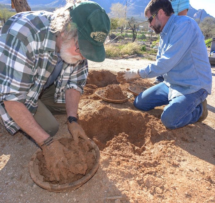 The southwest archaeologist has propelled his career by taking prehistoric technology into his hands and by learning from the past and teaching his students what life was like a thousand years ago. Denoyers passion for the past has taken many different forms, since junior high school, the self-taught flintknapper has created knifes, axes, spears, atlatls and now prehistoric pit houses. Archaeology Southwest, a local archaeology research firm, where Denoyer works, has long been responsible for expanding the prehistoric record by their survey of endangered sites and filling in the holes of existing knowledge about the folks who once lived here in the Sonoran Desert. So when Denoyer built his first pilot pit house, he was working from the knowledge gained from the past century of southwest archaeology and in partnership with the Town of Oro Valley and the Oro Valley Historical Society. In truth, most of what is known about the Hohokam pit house are the holes in the ground left behind by the wood uprights stuck in the ground centuries ago. The roofing, side and interior of these homes today are modeled on historic homes of the Hohokam descendents that today, are known as the Tohono O’odham and Pima people, of Southern Arizona.
When Hurricane Norbert dropped four inches of rain on Oro Valley last September, swelling washes to ten feet deep in places and requiring local fire and police to rescue motorists from swollen washes and flooded roadways. Loads of mud sloughed off Denoyers pit house completely filling it with water. That’s when the learning began for Archaeology Southwest who figured 40-50 percent of the mud was lost. Mud from the upper portions of the walls washed away or slumped in. The roof actually stayed relatively intact, with losses mostly confined to the edges. “But we don’t see this as a tragedy—in fact, we’re

Smoothing the mud produces a sheen that sheds the rain
 re-mudding they laid thatch mats over the new openings allowing air to circulate. Perhaps we need more thatching or interior support and possibly a different mixture of water and mud, to better combat the elements. Getting the moisture content of the earth just right is a real art, “I love the sound of the mud”, says Denoyer as he applies a rock to the wet surface smoothing it and creating a slick surface. “Floating the mud gives it a sheen and when the rain hits-it just rolls off.” “It really doesn’t take all that much work”, he says of pit house construction, “five or six people working together could finish in a couple of days”. “I love digging, screening earth, being out here all day. I’m so lucky so many people hate their work. At the end of the day, you can step back and appreciate what you accomplished.”
Archaeology Southwest has taken the next step to learn from the past, under the tutelage of Denoyer, the
research firm is offering several ongoing workshops, where participants will learn the basics of pit house  construction as archaeologists have learned from excavations. Denoyer will lead participants through the construction process, from excavation of the house pit to creating the superstructure, putting each student hands-on with traditional tools and materials. Through this work, Archaeology Southwest hopes to add detail to archaeological knowledge of how these structures were made by ancient people. Workshop sessions take place at Steam Pump Ranch in Oro Valley. Each session will last for three hours. Initial sessions will be dedicated to repairing rain-damages
  to the 2014 pit house. After that pit house is restored, participants will create small test pit houses that will enable us to compare how slightly different methods and materials respond to time and weather. Class Dates: Friday 3/6/15 from 9:00am-12:00pm – $40.00, Friday 3/13/15 from 9:00am-12:00pm, Friday 4/10/15 from 9:00am-12:00pm, Thursday 4/16/15 from 9:00am-12:00pm, Friday 4/24/15 from 9:00am-12:00pm -classes are for participants 18 years and older, there is a $40.00 charge.
ONE STUDENTS IMPRESSIONS ON THE HANDS-ON PIT HOUSE CLASS
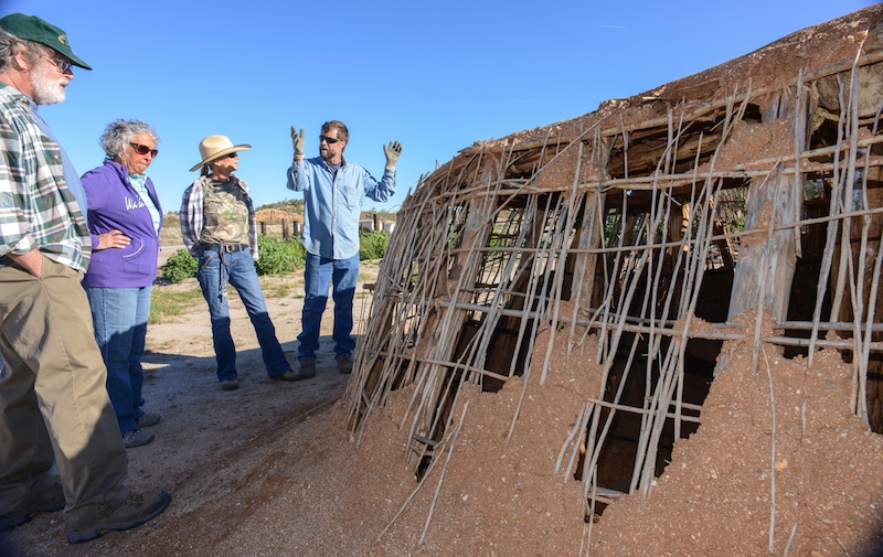
Allen Denoyer explains the class to Terri and Dave Wallace while Joyce Holloway listens to the plan.

Terri Wallace re-enforces the pit house wall with Seep Willows as support.
Denoyer has based the pit houses his classes are building on homes found in Honey Bee Village, an Oro Valley
Hohokam site, the 32 acres excavated by Henry Wallace, in 1986, his study turned up more than 2000 features, including 100’s of pit houses, a large plaza and a small ball court which established Honeybee as the economic center of several villages situated along the Canada del Oro River. The ball court Wallace believes was based on the Mesoamerican ball game, played with a rubber ball batted around with paddles perhaps resembling those used today in ping pong. The ball game, Wallace believes, was an “integrative tool” to bring folks together and exchange goods creating a “large trade fair”, around 800 AD, in the village’s center plaza. The larger excavation of the Tortolita foothills was undertaken by Desert Archaeology because of the advancing bulldozers for the development of the 5000 acre Rancho Vistoso housing project that today has covered over or bull-dozed many other sites right off the face of the earth. Honeybee’s sister site the larger “Sleeping Snake”, where “not much is left” says Wallace of the site now covered by a golf course. So when Wallace got to Honey Bee, the archaeologist trenched the village core and conducted a systemic shed collection, learning a lot about the residents of the 100’s
 of homes characterized by large oblong holes in the ground encircled by holes left by the pole uprights supporting the pit house village. Wallace believes the life of a pit house was 15-20 years and believed Honey Bee which was a “great place of ak-chin farming” said Wallace of the wide flood plain along Big Wash.
 It never supported more than a 100 people at any given time, saying the village’s population was “between 40-90 people at any given time” and that Honey Bee” was not alone but part of something larger”. Denoyer points out supplies were limited and not everyone could build a pit house whenever they wanted. “They wouldn’t pull out the plants”. which grew along side of the Canada del Oro River which provided weep willows, for the necessary wall and roof support, for the Hohokam pit house, instead “they would cut the plant and it would grow back the next year” and more homes could then be built. Carbon 14 dating has placed some of the wood found around 1050 AD, and Wallace feels the wood was carried a great distance, climbing into the Catalina Mountains and carrying it many miles home. There was a lot of competition for building supplies, Honey Bee was far from alone along the CDO, notably the Romero Ruin now protected in Catalina State Park and Rooney Ranch site was bulldozed, and now is named after a shopping center. There were fifty pit houses and the bulldozers had entire pots rolling down the hillside, along with burials from between 700AD to 1380AD. One pit house had an altar at one end, where a bighorn sheep’s lower jaw was found buried shows a large populations lived along along this stream and visited the high country to hunt and possibly worship. Henry Wallace believes the Catalina high lands brought spirituality to the Hohokam people, “so it was important to bring a piece into your home,” speaking of the large ridge poles carried from the mountain.
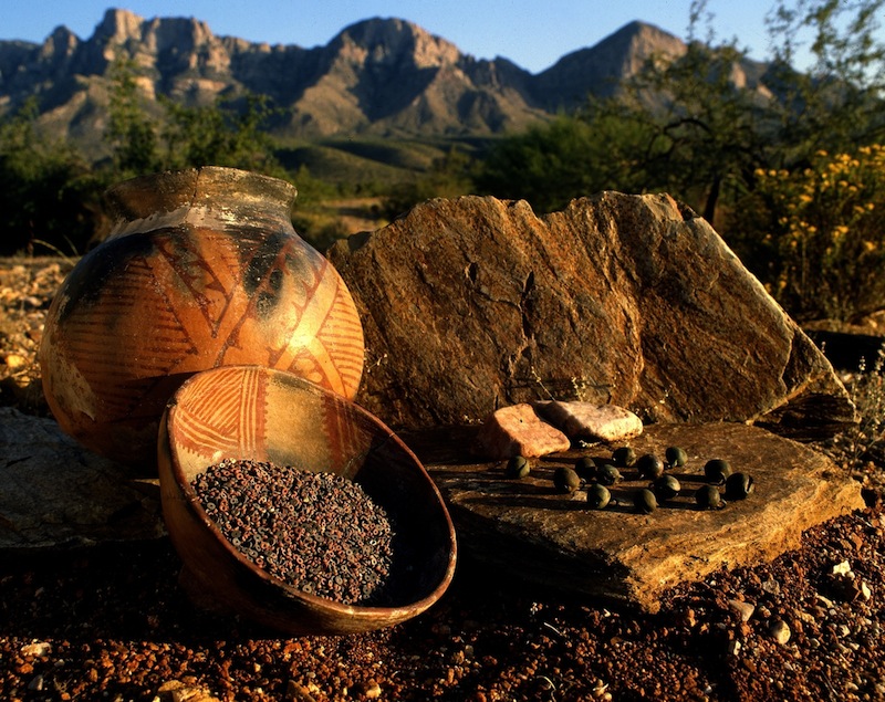
Today, archaeologist study a rich rock art site, surrounding the “easiest path to high altitude” up the Catalina Sutherland Ridge. In November 1949, a hunter’s foot broke through the earth’s crust and Ray Romo peered into the past. The broken ground revealed a Hohokam pot cupped over another larger pot, inside were 25 copper bells and a 100,000 beads, Emil Haury and Carol Gifford speculated that the Romo Cache was an offering to insure the welfare of a village. The beads weighed 3.5 pounds, some are made of steatite or talc. These are black. Some are of a ferruginous aphanitic matrix containing quartz grains. These are red. Some are of chryosolla or turquoise. These are green and blue. A dozen are made from seashells. The black beads make up 40 per cent, the red beads 58 per cent, turquoise beads about 2 per cent. Some have marks, showing they were worn at one time. The bells were all made in Jalisco, more than 1200 miles south in Mexico. Someone carried them here and carefully hide them in these rocks, below you would have seen Honey Bee, the larger Sleeping Snake Village and the Romero village and many more villages laced along the running Canada del Oro stream. Who left it, we can’t say nor do we know why ? Maybe it begged God for his blessing ! After the Aspen fire, lots of pottery showed up, along the pathway up to the Catalinas. Excavations turned up one bell at the Rooney Ranch site, one more bell was found at Honeybee village–whatever the message the Romo cache begged, “in 950 AD, the Tucson villages fragmented”, people were moving away from Honey Bee’s Plaza, “they were moving out”, says Wallace. “There was a drastic and sudden change in 1150.” “Perhaps warefare or environmental change and social divisions created by a hierarchy of people with power living over people,” speculates Wallace. “Not long after this, they are all gone…”

Henry Wallace shows a tour of the Honey Bee Preserve the ballcourt.
“It’s very sad” Wallace says, “that east ridge is where all the Hohokam houses were–that’s where all those new houses are now.” A coalition of groups recognizing the prehistoric value of the Honey Bee Village proposed a preservation effort about a decade ago. In 2006, Oro Valley and Pima County, through a land donation from Steve Solomon, owner of Canada Vistas Homes, the development company that purchased the land, together created the Honey Bee Village Preserve.
The new preserve was established to protect the large Hohokam Indian community that occupied the site between 700 AD and 1200 AD, according to archeologists. Honey Bee Village is located just north of the intersection of Rancho Vistoso Boulevard and Moore Road. Archeologists have identified the locations of hundreds of pit houses, a ball court, a walled compound and a central compound on the relatively undisturbed site where developers once intended to build the town center for Oro Valley. Preservation of the 13-acre village was possible with the $8 million donation of real estate placed into public trust. “On one hand, we have 13 acres of highly valuable real estate, and on the other hand we have an invaluable prehistoric resource that would be plowed over and lost forever,” said Steve Solomon, owner of Canada Vistas Homes, the development company that had originally purchased the land and donated it.

Wallace shows off a pit house site in the Honey Bee Preserve.
Today the 13-acre core of Honey Bee Village is now preserved for future generations. The preserve

Honey Bee Preserve Map

Neglected after the depression tall grass and trash became an issue
HONEY BEE VILLAGE PRESERVE TOUR CLICK HERE…
For South West archaeologist, the ubiquitous pit house, clouded the prehistoric picture of ancient man. The Hohokam is now known to be the primary prehistoric agriculturalist of the Sonoran Desert. This ancient man surrounded himself with Mother Earth to protect his family from his harsh environment, like the sun and rain, that fell from the sky or the cold that surrounded them. The pit house has roots in prehistoric times in the arctic, the desert, the mountains, the plains and in woodland areas over a large part of North America west of the Mississippi River. The earth-covered frame house changed slowly in architecture, no two pit houses were exactly alike but their features are typical of homes found in northeast Asia, across the Bering Strait, throughout North America and deep into South America. From the earliest dates, the pit house changed very little, it’s shape evolved from a square, to a rectangular, eventually taking an elliptical shape over the centuries. The Hohokam evolved their oblong pit homes with rounded ends, the front and back wall were parallel and sized approximately 6 meters wide x 3 meters depth.

Hohokam Pit House Drawing Copyright by Rob Ciaccio
Archaeologist find pit homes of the Plains cultures as far East as the U.S. southeast in Arkansas, there historical earth lodges of the plains Indian seem identical to the type used by the prehistoric man. Typically the pit house had four central roof supports in early homes, the supports increased later with a side entrance composed of a covered passage-way, inclined from the floor. The floor of well plastered caliche, was built on native soil. The fire pit was a deep basin in the interior with a thick coating of caliche, the rim being flush with the floor. Cross beams, spaced at irregular intervals, held a thatch of twigs and grass, which was covered with caliche. The dirt covering the roof extended down onto the walls, they were plastered and renewed as the need arose.
Many were burned, perhaps as part of a funeral rite ?
Archaeologist believe most villages were economically related through exchange systems, typified by the trading of shell bracelets and jewelry from the Sea of Cortez for cotton textiles from the Salt/Gila canal systems. A larger widespread trade network is suggested by the trade of shell from the Gulf of California, parrots and macaws from Mesoamerica and turquoise from various Arizona locations.
Villages were small with houses centered around plazas. During the Colonial Period AD 775-975 homes are arranged in house clusters or courtyard groups archaeologist Dave Wilcox finds two to four houses arranged with entrances facing a common courtyard and sites generally contain one or more house clusters. Many archaeologist see this as a time of expansion-the Sedentary Period 975-1150 AD saw continued growth of existing settlements and new villages sprang up along rivers and in the open desert. Irrigation canals expanded in the Salt Gila and houses increased in size. Public architecture like ball courts occur now, public architecture including platform mounds became more elaborate, some larger sites had one or more ball courts as well as platform mounds. After 1300 AD everything starts to diminish and withdraw – platform mounds begin to be encircled by adobe walls, the Casa Grande great house was built during the late classical period. Walled terraces or cerro de trencheras, were constructed on steep hillsides, in the Tucson Basin. Extensive agricultural farms are expanded in the desert regions and agave farms are expanded. Bill Doelle and Henry Wallace have argued the Tucson Basin emerged as a regional center during the Classic period, they suggest that cerro del trencheras were defensive and indicate warfare or the threat of warfare between the Tucson Basin and the Salt-Gila Complex (Phoenix). Archaeologist find an increase in site hierarchy along the Salt-Gila and the Tucson basin during the Colonial period. Ball courts were first constructed along the Canada del Oro and served to integrate a number of associated smaller villages within the Hohokam community. By AD 1000, the Hohokam were using all parts of the Tucson Basin, they built their villages along streams and rivers and hunted and gathered in the foothills and mountains.
BECOME A MEMBER OF ARCHAEOLOGY SOUTHWEST….CLICK HERE

Experience the ancient art of flintknapping. Join Allen Denoyer for his Hands-On Archaeology class, “How Did People Make and Use Stone Tools?”. In each of these beginner classes, you will use ancient techniques and replica tools to create a stone projectile point. You will also learn more about how people made and used such points, and that points were just one component of a complete hunting technology. The class is for individuals 18 years of age and older and lasts approximately 3 hours. This class will meet at Steam Pump Ranch at 10901 North Oracle Road, Oro Valley, AZ 85737. If you are interested in registering a group of three or more participants, please contact Kathleen Bader by phone at (520) 882-6946 x26 or by email to reserve space for your entire group. Class is Friday 3/20/15 from 9:00am-12:00pm – $40.00

“I love to making Clovis points”, says Allen Denoyer who often demonstrates prehistoric technologies at Steam Pump Ranch on Saturday mornings.”They are my favorite thing to make.”
PREHISTORY PHOTO COLLECTION OF PHOTOS CLICK HERE
![]()

<a href=” SPANISH TRANSLATIONS:">CLICK HERE
SELLS 75TH ALL INDIAN RODEO & FAIR, OLDEST IN THE UNITED STATES & BEST ENTERTAINMENT TICKET!


Yree Lepa
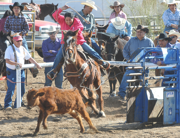
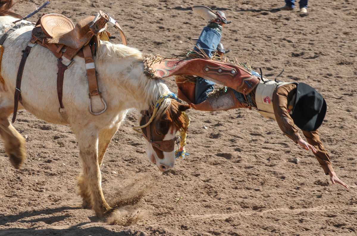
Celebrating the 75th year of the Tohono O’odham Nation Rodeo & Fair, the longest running All-Indian rodeo in the United States! The Rodeo & Fair is the biggest and most expansive event of the year. Bring the family out to enjoy the full experience there is sure to be something for everyone – rodeo competitions, traditional games, food, crafts, carnival rides, fun run, exhibits and performances. The U.S. longest-running American Indian rodeo has a Junior Rodeo which this year fielded 300 young ones, it has a powwow, carnival, parade, Wailia dances, and food/crafts at the Livestock Complex in Sells, 60 miles west of Tucson.  This year’s schedule ran from January 31 through February 3, 2013 at the Eugene P. Tashquinth Sr. Livestock Complex in Sells, Arizona. Named after the long-time voice of Tribal Rodeo’s, the Chu Chui resident (1929-2006) Eugene Tashquinth spent his days bringing order to chaos, heading up most of the events at the livestock area, so when they built the new one, they named it after Eugene Tashquinth. Equally proud is the Tohono O’odham Hedricks family whose matriarch Silas’s name blesses the Rodeo pavilion where he excelled in the arena, his grandson Chad Hedrick put the first score (6.3) on the clock with his bareback ride. Sells is a place of tradition and for the ten thousand residents of the third largest Indian reservation in the United States the annual rodeo and fair is a time of gathering, folks begin gathering before noon and the festivities go way into the night with the Wailia ending around l a.m.. The Rodeo and Pow Wow bring in native American competitors from all over the South West, particularly from Arizona tribes, like the Navajo, Hopi, San Carlos Apache, White Mountain Apache Tribe and their Tohono cousins: the Pima and Maricopa Tribes. Every year, is an old-home-town visit, with folks coming together to visit, catch-up, see who big all the cousins have gotten and to get new pictures of the kids.

 The mid-way is a beacon to all who love carnivals, greasy food, fast rides, regge music from Bob Marley, and tee shirts featuring heavy music idols and black goth signs. Visitors pay $8 for a wristband allowing all day access, for those over 55 years-of-age, the senior charge is $2. The annual Toka Tournament brings together the Tohono O’odham “Dream Teams”, like “Sun-Running-Women” who battle it out on a football sized field fighting over a wooden puck laced with leather and flung up-field with long sticks pulled from the ribs of the saguaro cactus. The start is much like the game lacrosse-another Indian game, it begins almost like a rugby scrum–and then off down field, very little is out of bound. These women celebrate this age old tradition all afternoon long with teams chasing each other up and down the playing field, the ebb and flow, the eventual goal and high-fives all around, losers too. The Pow Wow begins with the traditional Gourd Dance and breaks down into male, female, fancy, Plains categories featuring the finest in Pow Wow and Drum traditions. Just off the mid-way, the crowd not to photograph are the Yaqui Deer dancers nor can you record them with smartphones. The Yaqui Band features a combination of home-made instruments which accompany the dancers, one wears the head of a small deer atop the head, the main dancers each wore a mask to fill out the cast for their dance.

The Santa Rosa Shell Dancers
Earlier the Santa Rosa traditional dancers displayed their dance abilities, wearing their eye-catching shell-leg chaps, made from the shell carried from the Sea of Cortez by their ancestors who later traded the shell to Hohokam in the Salt-Gila River area for their cotton. The Tohono’s Hohokam ancestors valued the shell as a sign of rank, wealth, and much of it was fashioned into jewelry, like bracelets, necklaces, and leggings with shell leg tinklers for dancers The Tohono ancestors had a prehistoric salt trail across the vast waterless Sonoran Desert, across what is today’s US-MEXICO Border and into the blackened landscape of the Sierra de Pinacate lavafields, before crossing the enormous star sand dunes of the Grande Deserto for ten miles before reaching the Gulf of California where they harvested the precious salt and processed the shell, carrying home only what they needed to make jewelry to trade. Traditions have lasted thousands of years in the lands west of Tucson, they exist today and they will thrive tomorrow. The Tohono Tribe are gracious hosts and they welcome young and old, Indian or not as visitors to their Rodeo and Fair. It surprises me how few Tucsonans take advantage and visit the annual Tohono gathering, it surprises me more how few Tucson businesses sponsor, advertise or even acknowledge the tribe and its good work and its people of sterling, ageless character who have been our faithful neighbor for centuries.

SOUTHWEST PHOTOBANK GALLERY FOR MORE SELLS AZ RODEO PHOTOS CLICK HERE ….
2013 RODEO SCHEDULE…CLICK HERE
![]()
<a href=" SPANISH TRANSLATIONS:
SPANISH ENTRADA SEARCHES FOR CITY OF GOLD, CORONADO FINDS AMERICAN SOUTH WEST, SEES LITTLE TO VALUE EVEN LESS TO CARRY OFF!


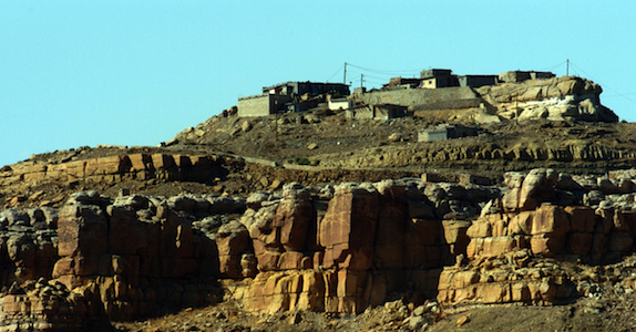
THE SPANISH ENTRADA AND CORONADO VISITED MANY OF THE RIO GRANDE PUEBLOS. THE TAOS PUEBLO (above) WAS VISITED BY OUT-RIDERS AFTER DEFEATING CIBOLA OR TODAY’S ZUNI PUEBLO IN NEW MEXICO.
Crossing into the US from Mexico at this spot in the San Rafael Valley, the Franciscan friar FRAY MARCUS de NIZA with his Moorish guide, Estevan, entered from Mexico at this spot in Arizona’s San Rafael Valley, where this concrete cross stands as a memorial of decades of Spanish rule in North America which was followed by a “tidal wave of white men”. De Niza’s journey ended South West prehistory and marked the beginning of written history.
Beside this dusty dirt road only a short distance north from Lochiel, Az, stands the 20 foot cross with a metal plaque that proclaims “On this spot FRAY MARCUS de NIZA entered this Valley of San Rafael, as Commissary of the Franciscan Order and a Delegate of the Viceroy of Mexico, de Niza entered Arizona the first European west of the Rockies on April 12, 1539. Here began the friar’s historic journey to explore the American Southwest, his journey ignited a decade of searching by conquistadors for the gold and riches they hoped to exist in the legendary “Seven Cities of Cibola”.[caption id="attachment_5114" align="aligncenter" width="950"] Marks de Niza Entry
Ironically, at the time of the march to Cibola (Zuni N.M.) and Quivira (Kansas) in 1541, Hernando de Soto’s army was probing west from Florida. In May of 1541, at the same time Coronado was in Texas and starting north to Kansas, de Soto was crossing to the west bank of the Mississippi River. The armies may have passed within some hundreds of miles of each other. While Coronado was in Kansas and marching back to the Albuquerque area, De Soto was probing west of the Mississippi, where he died on the Red River in April of 1542. If the two armies had met up, they might have considered their expeditions more successful.

CONQUISTADORS CLIMBED INTO THE SKY CITY OF ACOMA, THEY WISHED THEY HADN’T.

NATURAL WATER CATCHMENTS ARRESTED RUNOFF ON THE MESA FLOOR

A POTTERY TRADITION EXISTS IN MOST PUEBLOS.

NORTH CENTRAL NEW MEXICO
De Niza’s visit to Arizona’s opened the door for Spanish exploration that defined the size, the people and the nature of today’s American West. FRAY MARCUS de NIZA, found himself about 15 miles east of what is today’s Nogales, Arizona and Sonora as their horses picked their trail through the rich Arizona grasslands. De Niza was guided by Estevan, an Moor slave who had survived the same decade of slavery and walking through Texas to Mexico after being ship-wrecked off the Florida coast with the Spanish mariner named Álvar Núñez Cabeza de Vaca who reported to the Viceroy of Mexico the riches of Cibola. The Viceroy sent the Friar de Niza and Estevan to learn the truth about “Cibola”, was it made from gold or wasn’t it? Estevan knew from his travels the Indian of the time perceived “Cibola” as the “greatest thing in the world”, so-the servant said. Survival had taught him how to excite the average Indian village, the large charismatic black man who wore tinkers and led a large entourage of slaves and women whom he had collected. Estevan had learned it was better to be the point of the spear ahead of the main expedition finding water and probing their path for guides and information, rather than playing the role of a slave. Estevan was charged to send back runners with crosses, if news was promising about riches ahead send a big cross, he had been told, if chances were poor, then send a small cross. Estevan decided to promote his own agenda sending back crosses that got progressively larger. Estevan was the original Kokopelli, he captivated the locals, wowed the maidens, had a few and moved on to the next village before the larger expedition arrived.

FIREARMS, HORSES AND CROSSBOWS TOOK A TOLL ON THE INDIAN
De Niza, upon his first return to Mexico City from Cibola, he had reported finding “good and prosperous lands” others soon twisted that translation into a new land of riches, equal to the wealth of gold, silver and gemstones, taken from the Aztec and Inca civilizations of Mexico and South America. Cibola was soon thought to be where “trees hung with golden bells and people whose pots and pans were beaten gold”, so with that promise of riches, finding soldiers and patrons to fund the journey became easy, everyone wanted a piece of the action. De Niza’s companion Estevan de Dorantes was killed at Cíbola, as de Niza watched from afar, but from that range the friar affirmed that the “grand city” report was true. The Friar’s report had inspired Francisco Vázquez de Coronado to make his famous expedition to Zuni Pueblo, using Fray Marcos as his guide; their journey had many hardships: thirst and hunger, many died and most were left penny-less. So it’s an understatement the expedition had a great disappointment, when they had finally saw Cibola for themselves, Coronado then sent Friar de Niza back to Mexico City for his own protection. Fray Marcos returned in shame and became the provincial superior of his order in Mexico and performed the highest office of the Franciscans Order in Mexico before dying in 1558.
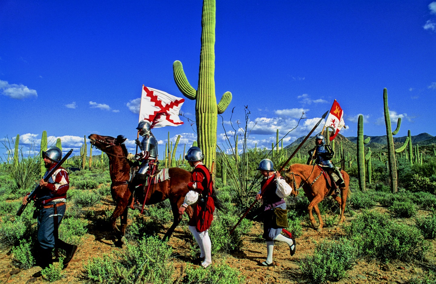
In “Cities of Gold” by Doug Preston 1992 Simon/Schuster narrates the rich history of the American South West as the author retraces the Route of Coronado from the US-Mexico Border through a very rugged Arizona and into a waterless New Mexico. Preston and with his cowboy/photographer/artist/sidekick, Walter, with four horses found the trip, life-imperiling as well as life-changing. Another author, Paul Wellman wrote in his book; “Glory, God and Gold” that “Every Spaniard in the expedition” he wrote “would plunge his arms elbow-deep in gold ingots before he returned,” that’s why not a peso came from the King and each participant paid what they could. Captains paid $55,000 pesos, average guys paid $35,000 pesos and Coronado himself paid $85,000 pesos, taking a loan out on his wife’s estate. In preparation for this journey, Coronado had taken seven slaves four men and three women, others took their wives, children and companions.
Scholars say there were 2,000 in the expedition, with 67 plus European soldiers-45 fellas carried European metal helmets, 1300 natives were from central and western Mexico, some were servants, wranglers and herdsmen so writes Richard Flint in the Kiva article entitled “What they never told you about the Coronado Expedition”. He points out there were 19 crossbow, 25 arquebusiers and additional slaves to tend the 1,000 extra horses, 500 head of cattle, and more than 5,000 sheep was taken to feed the expedition. These folks were not trailblazers-they followed well established paths, each village they passed they would enlist guides to lead the way to the next water hole, to make introductions at the next village and to show the Spanish the road to the Seven Cities of Gold.
Just a few years earlier the chosen champion of the Cuban governor, Conquistador Hernando de Soto, who learned the Indian slave trade in South America. There the Spanish looted temples and ransacked graves for their mortuary offerings. Finally De Soto captured the Inca emperor who offered him a room 22′ by 17′ stacked 9′ to the ceiling with gold ornaments, vases, goblets and statues plus another smaller room filled twice over with silver for his freedom. De Soto accepted the gold and silver treasure, still killed the king and soon returned to Spain and became a favorite in the King’s court to whom he loaned money and soon was given the license to explore Florida. In return the King was to receive “one-fifth of all spoils of battle, one-fifth of any precious metal taken from the ground and one-tenth of everything taken from graves. De Soto was to finance the entire expedition, at its end he would received 50,000 acres of his choice and an annual salary of $60,000, in return he would pacify all the natives, and provide the necessary priests and friars needed to convert them.

DESOTO; Followed the footsteps of his heroes, Balboa and Ponce de Leon….

CORONADO: Freely joined the chase for gold and riches ….

EL MORRO NATIONAL MONUMENT STOOD OUT FROM THE FLAT LAND AND BECAME A BEACON FOR TRAVELERS. CORONADO DIDN’T LEAVE HIS JOHN HANCOCK, BUT HE DID VISIT

The native Americans believed the Spanish horses were supernatural creatures.
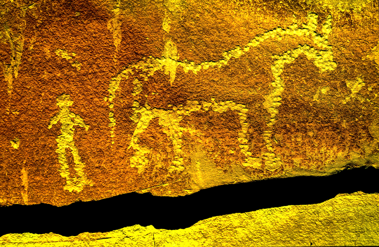
This rock art in southern Utah commemorates the first time the indian and the horse meet.
So eighty years before the Pilgrims landed at Plymouth Rock. Spanish Explorers visited Kansas: Francisco Vasquez de Coronado, seeking gold in New Mexico, was told of Quivera where “people’s pots and pans were beaten gold”. With 30 picked horsemen and a Franciscan Friar, Coronado marched “north by the needle” from the Texas panhandle until he reached Kansas. Here he found no gold, but a country he described as “the best I have ever seen for producing all the products of Spain.” The expedition entered present Kansas near Liberal and moved northeastward across the Arkansas River to what is now Rice and McPherson counties perhaps probing to present day Lawrence near the Kansas River before turning back. The guide, they called the Turk, confessed he had deceived the Spaniards and one night he went into his tent and the next morning when they broke camp he left only a dirt mound. He was strangled, buried and forgotten. For 25 days in the summer of 1541 the Turk had led Coronado among the grass-hut villages of the Quivira Indians, hoping to lose Coronado and men in the tall grass and waterless plains.

PECOS PUEBLO stood at the Cross Roads of the Great Plains and the Rio Grande Pueblo Communities.

Statue of the Conquistador Coronado stands next to a traffic circle in Liberal, Kansas near where the Spanish entered from Texas. JOHN MADSEN, BELOW
CORONADO AND QUIVIRA

The exact route that the Coronado Expedition took between Sonora and the Zuni Pueblos is currently unknown writes John Madsen, curator at the Arizona State Museum. He writes some have surmised that the trail led through Arizona, as far west as the Casa Grande Ruin, before turning northeast into the White Mountains region. Others, like historian Herbert E. Bolton, suggest a route along the San Pedro River, turning northeast below Benson, crossing the Gila River near Bylas, and passing near White River and Springerville before descending into the Zuni region. Madsen prefers the path similar to that proposed by archaeologist Carroll Riley. It traverses the country on what is now the Arizona–New Mexico state line, following the San Francisco River. Spanish accounts as early as 1747 reveal considerable use of the drainage by Zunis and Apaches. In 1795, Sonorans viewed the San Francisco River area as a potential trade route linking them with the Pueblo of Zuni and Santa Fe area pueblos like Pecos and Taos Pueblos.
Madsen teamed up with a Public Broadcast Station and launched a search for clues of where the Spanish had been targeting areas along their suspected route. Many historians and archaeologists along the route have tackled their piece of the mystery, many adding to the research, Madsen “had a hunch that the best source of information would come from the ranching communities along the Arizona–New Mexico border. These people know the land, and generations of family members have covered most of this dirt on horseback. The end result were 33 Spanish colonial period or Mexican historic artifacts like period spurs, coins, and horseshoes. Chain mail was take from a site in Kansas….more clues appeared.
Hartmann Map for Tracking the Expedition’s Route: Sleuthing for Clues and Artifacts

For over 100 years, the exact route of Coronado has been an American mystery. Generations of scholars have tried to retrace the steps of the army from their descriptions of villages, rivers, mountains, and native communities. National commissions have grappled with the problem of designating a “Coronado Trail” that tourists could follow, but clues were sparse, and politics raised its head when various factions tried to claim parts of the route for their state. Because we don’t know just where they were, it is tantalizingly hard to interpret the Coronado chronicles’ descriptions of native villages and other sites they visited.

GREENLEE COUNTY ARIZONA
Archaeologists William K.Hartmann, his wife Gayle and Richard Flint have worked tirelessly to sleuth out the route of the Coronado Expedition being guided by de Niza who the year before had seen Cibola from a distance. They found he might have followed the Rio Sonora to the river’s headwaters and then crossed the Cananea grasslands for four days past Arizape picking up the San Pedro River North turning east toward the Wilcox Playa North past present day Safford or the present day Sulfur Springs Valley crossing the Gila River cresting the Mogollon Rim past Point of Pines. William and Gayle Hartmann sees them moving east from the San Pedro, stopping at Turkey Creek in the Chiricahua’s then moving east through Apache Pass via Portal and into New Mexico and eventually into Texas. For more explanation visit their website….http://www.psi.edu/epo/coronado/coronadosjourney.html
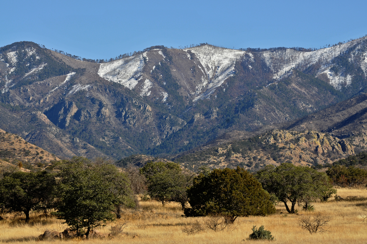
WEST TURKEY CREEK, IN THE CHIRICAHUA MOUNTAIN RANGE, ONE PROPOSED STOP ALONG CORONADO’S ROUTE.
REPORTED DISCOVERY OF CHICHILTICALE The most exciting development is the apparent discovery of the long lost Coronado camp site at the Chichilticale New Mexican exploration geologist Nugent Brasher devoted several years to this problem. With brilliant deduction, mapping, and hard work, he began metal detecting surveys at several water-source sites he reported finding an iron cross bow point and other possible fragments from the Kuykendall ruin, a large pueblo ruin site at the foot of the Chiricahuas. The site appears definitely to be a the first Coronado camp site known in Arizona, and almost certainly is the Chichilticale ruin.
• ONGOING EXCAVATIONS AT CHICHILTICALE Brasher has set up a web site at www.chichilticale.com to record progress with the survey and excavations at the Chichilticale site. Excavations are continuing by Brasher and archaeologist Deni Seymour. Two more cross bow bolt heads have been shown on her web site that details excavation plans and progress, at http://www.seymourharlan.com/default.htm
• NEW BOOK FROM RICHARD FLINT In 2008, Richard Flint published a popular-level account of the expedition, “No Settlement No Conquest: A History of the Coronado Entrada,” a book that bids to replace Herbert Bolton’s volume as the best general account of the expedition.
• NEW BOOK FROM TONY HORWITZ In 2008, also, Pulitzer-prize winning journalist/writer Tony Horwitz dealt with the Coronado expedition as a major section of his book “A Voyage Long and Strange,” which is an account of the explorations in North America before the 1700s, adjusting and correcting some of the mythic tales that most American children learn about the initial European explorations of our continent.
Picked up by a local rancher In the 1960s and Little known for years, the Floydada gauntlet and some newly-found associated artifacts, such as odd-shaped metal arrow points, have recently been recognized as priceless relics of the Coronado army expedition.
THE JIMMY OWENS SITE IS LOCATED NEAR FLOYDADA ON THE TEXAS PANHANDLE SEE PICTURES OF COLONIAL SPANISH ARTIFACTS, SPURS, MESH GLOVE…
KIVA The Coronado Expedition to Tierra Nueva: The 1540–1542 Route across the Southwest by Richard Flint; Shirley Cushing Flint
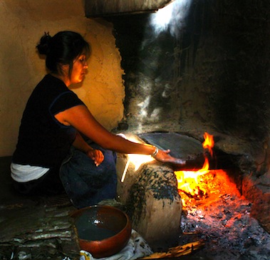
HOPI WOMEN have been making the ceremonial PIKI Bread for centuries in a special cooking space behind the main house

AFTERMATH of DE NIZA’S JOURNEY TO CIBOLA
Cultures, old as time, were attacked as pagan by the Catholic priests who accompanied the Conquistadors and who blessed their cruel attacks, in the name of saving pagan souls. The vanquished Indian was used as slaves, sold, slain or simply worked to death. The Cross, the symbol the Spanish brought the Indian and who adopted it, as pagans you can always use another God. Finally, the Spanish opened the West, the Conquistadors began the mapping of the West which became the United States of America’s quest for it’s “manifest destiny”. The American Indian, time and time again found himself in the way of the white man’s greed, the white men attacked the first Americans stealing their lands, their game and their lives, their homes, eventually they stole their children!
The facts show the journey of FRAY MARCUS de NIZA, a man of God, began an “era of extermination”, a period when approximately 20 million Indians inhabited this territory before the Conquest, and after just one century of Spanish rule there were only 1 million left! Many vanquished by Old World diseases brought to the New World with Europeans. The epidemics that broke out as well as the merciless workload imposed on the Indian dramatically diminished the Indian population. The scope of the epidemics over the years was tremendous, killing millions of people—in excess of 90% of the population in the hardest hit areas—and creating one of “the greatest human catastrophe in history, the most devastating disease was smallpox, but other deadly diseases included typhus, measles, influenza, bubonic plague, cholera, malaria, tuberculosis, mumps, yellow fever, and pertussis (whooping cough). The Americas also had a number of local diseases, such as tuberculosis and a type of syphilis, which soon went viral when taken back to the Old World.
“The moving multitude…darkened the whole plains,” wrote Lewis and Clark, who encountered a buffalo herd at South Dakota’s White River in 1806. With westward expansion of the American frontier, systematic reduction of the plains herds had began around 1830, when buffalo hunting became the chief industry of the plains, organized hunters killed buffalo for hides and meat, often killing 250 a day.

The White Man also almost exterminated the American Buffalo, herds said to be 20 miles wide and 20 miles deep, roaming the valleys they have always grazed, only a few small herds survive today. At that time, some white men sought to eradicate the buffalo to take away the Indian’s livelihood and well-being. Native American tribes depended on the buffalo’s meat and hides, and many still today believe the animal has special spiritual and healing powers, making it an important part of their culture. The railroads laying track across the plains further depleted the buffalo, as well as the Indian’s hunting grounds because hunting from train windows was widely advertised and passengers shot buffalo as they raced beside the trains. By 1883 both the northern and the southern herds had been destroyed. Less than 300 wild animals remained in the U.S. and Canada by the turn of the century out of the 30 to 75 million that was once thought to live there.
The Navajo “Long Walk” was the 1864 forced-deportation and some say attempted ethnic cleansing of the Navajo by the U.S. Government notes Wikipedia. The Navajos were forced to walk at gunpoint from their Arizona reservation to eastern New Mexico. Some 53 different forced marches occurred between August 1864 and the end of 1866. The “Trail of Tears” is a name given to the forced relocation and movement of Native American nations from southeastern parts of the United States Many of re-settled Indians suffered from exposure, disease and starvation on the way, many died, including 4,000 of the 15,000 relocated Cherokee. By 1837, 46,000 Native Americans from southeastern states had been removed from their homelands opening 25 million acres for predominantly white settlement.
SOUTHWESTPHOTOBANK’S PREHISTORY PHOTO GALLERIES CLICK HERE….
CONQUISTADOR ARMOUR BY ERIC THING
![]()
<a href=" SPANISH TRANSLATIONS:


