
END OF THE WORLD COMING ON SOLSTICE ? WHITE BUFFALO WOMEN SAYS LOVE THE WORLD AND EACH OTHER LOVE WILL RETURN BALANCE TO OUR WORLD !

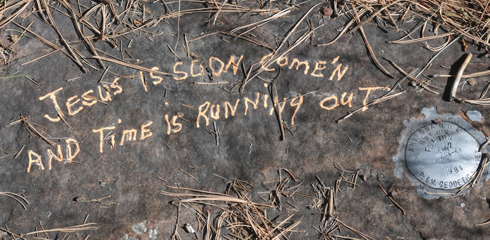
Much has been said about the upcoming end of the World on December 21st! During the election driving through north central Arizona I heard a Christian talk show blame it om Obama, since then Conservative are convinced a black president is truly the end of us all. FEAR…seems to be the message coming from a broad segment of the population, 24 hour cable news keep the most pressing world events center-stage. Right vs Left battles over your health care. Christian folks stabbing people after provoking them in the first place, all in the name of saving newborn. Mass shootings are on a record track and we have just experienced one of the worst in our country’s history, twenty innocent children gunned down. In a sense we find our World tilting out of alignment. In my view it is less a gun control problem than one Ronald Regan began when he mainstreamed the mentally ill, reducing services and forcing a new homeless revolution, mainly by people who can not exist within the framework of society as we know it. This is no small number and because the government and state’s have no funding to provide services for the mentally ill and homeless a terrible stigma has grown up around both the person who lives on the street and those Americans battling their inner demons.

Universal health care is the beginning! In the decades to come it will make a difference. Still we are bedeviled by Global Warming and in some places steps are being taken to battle our changing world. New York and New Jersey is trying to rebuild in a way that protects the regions worst hit by Hurricane Sandy, the Gulf of Mexico has received some expensive first aid from the BP Oil Spill and the gulf is mending slowly and is being watched, studied closely.
Banks, lobbyists have run rampant, like the money changers in the Temples, they have corrupted everything they touched. Mostly law makers and their staffs, their money has bought influence at the expense of the public welfare and still they battle for de-regulation–it is one constant attack on all fronts, whittling down laws and clawing regs in place to protect the health and best interests of all Americans. Collective bargaining is a thing of the past.
WHY THE WORLD WILL NOT END IN DECEMBER 2012
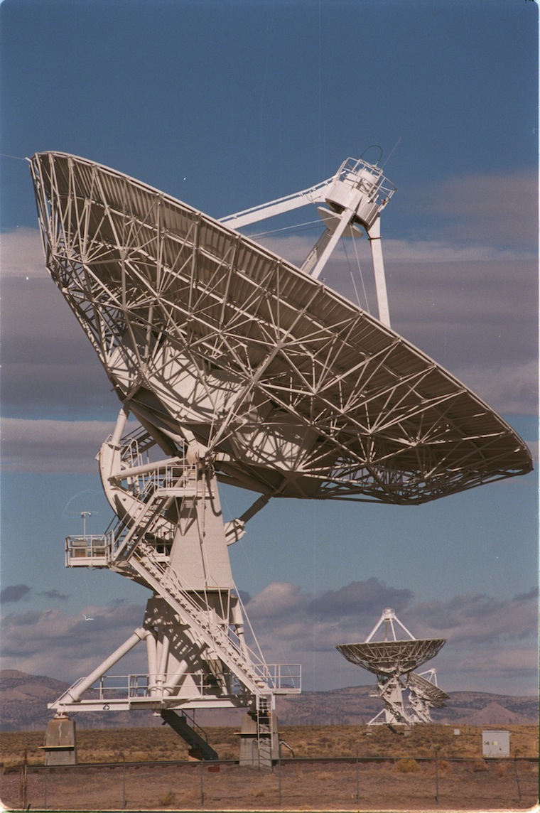
Join us in person at SETI Institute in Mountain View. David Morrison, Ed Krupp and Andrew Fraknoi will discuss the topic of the end of the Mayan Calendar in 2012 and how this has been treated by the media. The negative effect on the public of this millennial memo will also be explored, Speakers: David Morrison, NASA Ames Research Center. Ed Krupp, Griffith Observatory, Southern California. Andrew Fraknoi, Foothill College.

The SETI Institute is a not-for-profit organization whose mission is to “explore, understand and explain the origin, nature and prevalence of life in the universe”. SETI stands for the “search for extraterrestrial intelligence”. One program is the use of both radio and optical telescopes to search for deliberate signals from extraterrestrial intelligence. Other research, pursued within the Carl Sagan Center for the Study of Life in the Universe, includes the discovery of extrasolar planets, potentials for life on Mars and other bodies within the Solar System, and the habitability of the galaxy. Photo taken near Socorro, New Mexico.
So why in this time of all these horrible pressures on our way of life do we possibly believe America and the rest of the World, Europe, Africa, the Middle East can pull out of this deadly spiral, pull up and level off. For beginners, the Mayan calendar says so it goes on and besides what is reported, it continues. Secondly, there is now a level of optimism across our country that conveys a hopefulness, in spite of all the Republicans, acting as if the world in going to end. Mitts dog will get more road trips, besides, the price of gas has been dropping ever since they started investigating why it was so high. It wouldn’t be fair if the world can to an end now. NORAD, the folks that track space junk, satellites, incoming asteroids, comets, Death stars, like in Independence Day they already had a picture. NORAD says there is nothing on the horizon that would bring an end our world! So with the world tilting off its axis and when many believe it is spinning out of control and when some believe it is all over. I’m here to say — wait a minute. Yes, this World has lost some of its beauty, it is an ugly world and many people I know say the future will not be nearly as prosperous and promising for their children, as their generation enjoyed. Maybe or maybe not, my view that has always depended upon the individual and what they were willing to work for.
So besides all the hopeful reasons I have already conveyed to you, I have two words more for you White Buffaloes!

WHITE BUFFALO

ARIZONA’S BEARIZONA HAS WHITE BUFFALO
News of the calf spread quickly through the Native American community because its birth fulfilled a 2,000 year old prophecy of northern Plains Indians. Joseph Chasing Horse, traditional leader of the Lakota nation, explains that 2,000 years ago a young woman who first appeared in the shape of a white buffalo gave the Lakota’s ancestors a sacred pipe and sacred ceremonies and made them guardians of the Black Hills. Before leaving, WHITE BUFFALO WOMEN prophesied that one day she would return to purify the world, bringing back spiritual balance and harmony; the birth of a white buffalo calf would be a sign that her return was at hand.
“The White Buffalo is a blessing from the Great Spirit. “It’s a sign”. These white buffaloes are showing us that everything is going to be okay.”
The White Buffalo Woman showed the people the right way to pray, the right words and the right gestures. She taught them how to sing the pipe-filling song and how to lift the pipe up to the sky, toward Grandfather, and down toward Grandmother Earth, to Uncie, and then to the four directions of the universe. “With this holy pipe,” she said, “you will walk like a living prayer. With your feet resting upon the earth and the pipestem reaching into the sky, your body forms a living bridge between the Sacred Beneath and the Sacred Above. Wakan Tanka smiles upon us, because now we are as one: earth, sky, all living things, the two-legged, the four-legged, the winged ones, the trees, the grasses. Together with the people, they are all related, one family. The pipe holds them all together.”
“Look at this bowl,” said the White Buffalo Woman. “Its stone represents the buffalo, but also the flesh and blood of the red man. The buffalo represents the universe and the four directions, because he stands on four legs, for the four ages of man. The buffalo was put in the west by Wakan Tanka at the making of the world, to hold back the waters. Every year he loses one hair, and in every one of the four ages he loses a leg. The Sacred Hoop will end when all the hair and legs of the great buffalo are gone, and the water comes back to cover the Earth.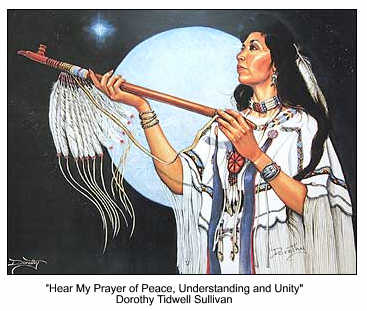
The wooden stem of this chanunpa stands for all that grows on the earth. Twelve feathers hanging from where the stem the backbone joins the bowl the skull are from Wanblee Galeshka, the spotted eagle, the very sacred who is the Great Spirit’s messenger and the wisest of all cry out to Tunkashila . Look at the bowl: engraved in it are seven circles of various sizes. They stand for the seven ceremonies you will practice with this pipe, and for the Ocheti Shakowin , the seven sacred campfires of our Lakota nation.”
The White Buffalo Woman then spoke to the women, telling them that it was the work of their hands and the fruit of their bodies which kept the people alive. “You are from the mother earth,” she told them. “What you are doing is as great as what warriors do.” And therefore the sacred pipe is also something that binds men and women together in a circle of love. It is the one holy object in the making of which both men and women have a hand. The men carve the bowl and make the stem; the women decorate it with bands of colored porcupine quills. When a man takes a wife, they both hold the pipe at the same time and red cloth is wound around their hands, thus tying them together for life.
And when she promised to return again, she made some prophesies at that time ….One of those prophesies was that the birth of a white buffalo calf would be a sign that it would be near the time when she would return again to purify the world. What she meant by that was that she would bring back harmony again and balance, spiritually.
The woman gave the people a sacred pipe, taught them how to use it to pray and told the Sioux about the value of the buffalo. Before she left them, the woman said she would return, the legend says.
As she walked away she turned into a young white buffalo.
The return of White Buffalo Calf Woman marks the arrival of a new era of reconciliation among races and respect for the Earth. (excerpts borrowed from an article in the Chicago Tribune by Richard Wronski)
SEE BIRTH OF WHITE BUFFALO http://www.youtube.com/watch?v=LteJdKp54yg
BIRTH OF WHITE BUFFALO FULFILLS TRIBAL PROPHESY…CLICK HERE

WHITE BUFFALO WOMEN
SACRED NINE COMMANDMENTS FROM THE CREATOR TO NATIVE PEOPLE AT THE TIME OF CREATION
1. Take care of Mother Earth and the other colors of man.
2. Respect this Mother Earth and creation.
3. Honor all life, and support that honor.
4. Be grateful from the heart for all life. It is through life that there is survival. Thank the Creator at all times for all life.
5. Love, and express that love.
6. Be humble. Humility is the gift of wisdom and understanding.
7. Be kind with one’s self and with others.
8. Share feelings and personal concerns and commitments.
9. Be honest with one’s self and with others. Be responsible for these sacred instructions and share them with other nations.
NATIONAL INSTITUTE FOR CIVIL DISCOURSE…CLICK HERE

SAINT KATERI TEKAKWITHA
WORDS TO LIVE BY …. IT’S A NEW YEAR ! WHY NOT A NEW WORLD !
WHITE BUFFALO WOMEN HAS SHOWN THE WORLD HOW TO LOAD THE PIPE THAT BRINGS HARMONY TO THE WORLD. AFTER WASHINGTON AND COLORADO PASSED NEW MARIJUANA LAWS RELAXING THE STIGMA OF POSSESSION AND SMOKING THE WEED THERE IS LITTLE DOUBT IN MY MIND WHAT THEY WILL BURNING IN THAT PIPE.
This summer the Vatican ordained its first Native American Saint, Saint Kateri Tekakwitha, was canonized on 10/21/2012 by Pope Benedict XVI, two months to the day before the World Ends. In his remarks the Pope said he hoped the love of Saint Tekakwitha would bring together all Native Americans and all people. He “hoped she would be the great unifier”
SEE PHOTO GALLERY ON CELEBRATION OF SAINT KATERI TEKAKWITHA AT SAN XAVIER CLICK HERE….
SEE THIS END OF THE WORLD BLOG ON PROTECTING YOUR FAMILY FROM ZOMBIES….CLICK HERE
![]()

<a href=" SPANISH TRANSLATIONS:
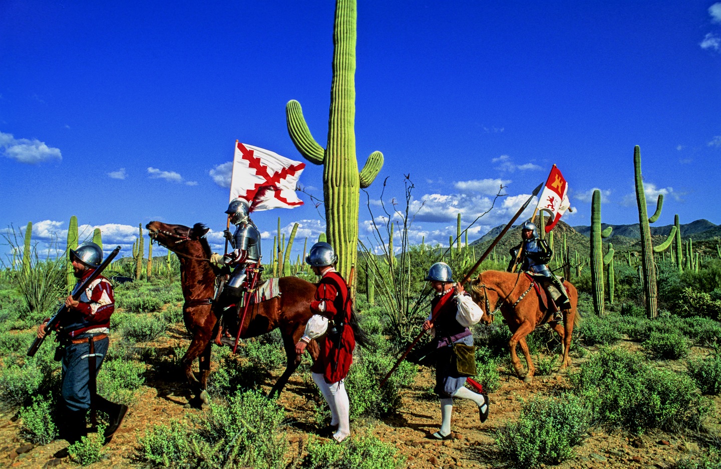
SPANISH ENTRADA SEARCHES FOR CITY OF GOLD, CORONADO FINDS AMERICAN SOUTH WEST, SEES LITTLE TO VALUE EVEN LESS TO CARRY OFF!


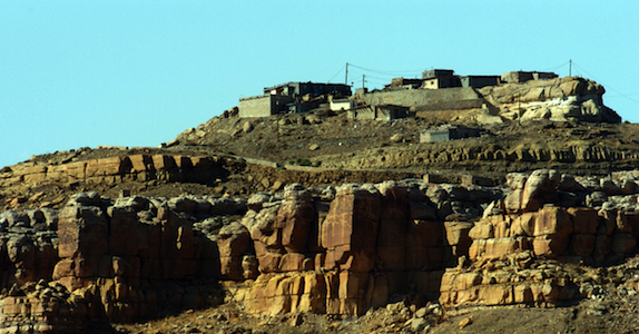
THE SPANISH ENTRADA AND CORONADO VISITED MANY OF THE RIO GRANDE PUEBLOS. THE TAOS PUEBLO (above) WAS VISITED BY OUT-RIDERS AFTER DEFEATING CIBOLA OR TODAY’S ZUNI PUEBLO IN NEW MEXICO.
Crossing into the US from Mexico at this spot in the San Rafael Valley, the Franciscan friar FRAY MARCUS de NIZA with his Moorish guide, Estevan, entered from Mexico at this spot in Arizona’s San Rafael Valley, where this concrete cross stands as a memorial of decades of Spanish rule in North America which was followed by a “tidal wave of white men”. De Niza’s journey ended South West prehistory and marked the beginning of written history.
Beside this dusty dirt road only a short distance north from Lochiel, Az, stands the 20 foot cross with a metal plaque that proclaims “On this spot FRAY MARCUS de NIZA entered this Valley of San Rafael, as Commissary of the Franciscan Order and a Delegate of the Viceroy of Mexico, de Niza entered Arizona the first European west of the Rockies on April 12, 1539. Here began the friar’s historic journey to explore the American Southwest, his journey ignited a decade of searching by conquistadors for the gold and riches they hoped to exist in the legendary “Seven Cities of Cibola”.[caption id="attachment_5114" align="aligncenter" width="950"] Marks de Niza Entry
Ironically, at the time of the march to Cibola (Zuni N.M.) and Quivira (Kansas) in 1541, Hernando de Soto’s army was probing west from Florida. In May of 1541, at the same time Coronado was in Texas and starting north to Kansas, de Soto was crossing to the west bank of the Mississippi River. The armies may have passed within some hundreds of miles of each other. While Coronado was in Kansas and marching back to the Albuquerque area, De Soto was probing west of the Mississippi, where he died on the Red River in April of 1542. If the two armies had met up, they might have considered their expeditions more successful.

CONQUISTADORS CLIMBED INTO THE SKY CITY OF ACOMA, THEY WISHED THEY HADN’T.

NATURAL WATER CATCHMENTS ARRESTED RUNOFF ON THE MESA FLOOR

A POTTERY TRADITION EXISTS IN MOST PUEBLOS.

NORTH CENTRAL NEW MEXICO
De Niza’s visit to Arizona’s opened the door for Spanish exploration that defined the size, the people and the nature of today’s American West. FRAY MARCUS de NIZA, found himself about 15 miles east of what is today’s Nogales, Arizona and Sonora as their horses picked their trail through the rich Arizona grasslands. De Niza was guided by Estevan, an Moor slave who had survived the same decade of slavery and walking through Texas to Mexico after being ship-wrecked off the Florida coast with the Spanish mariner named Álvar Núñez Cabeza de Vaca who reported to the Viceroy of Mexico the riches of Cibola. The Viceroy sent the Friar de Niza and Estevan to learn the truth about “Cibola”, was it made from gold or wasn’t it? Estevan knew from his travels the Indian of the time perceived “Cibola” as the “greatest thing in the world”, so-the servant said. Survival had taught him how to excite the average Indian village, the large charismatic black man who wore tinkers and led a large entourage of slaves and women whom he had collected. Estevan had learned it was better to be the point of the spear ahead of the main expedition finding water and probing their path for guides and information, rather than playing the role of a slave. Estevan was charged to send back runners with crosses, if news was promising about riches ahead send a big cross, he had been told, if chances were poor, then send a small cross. Estevan decided to promote his own agenda sending back crosses that got progressively larger. Estevan was the original Kokopelli, he captivated the locals, wowed the maidens, had a few and moved on to the next village before the larger expedition arrived.

FIREARMS, HORSES AND CROSSBOWS TOOK A TOLL ON THE INDIAN
De Niza, upon his first return to Mexico City from Cibola, he had reported finding “good and prosperous lands” others soon twisted that translation into a new land of riches, equal to the wealth of gold, silver and gemstones, taken from the Aztec and Inca civilizations of Mexico and South America. Cibola was soon thought to be where “trees hung with golden bells and people whose pots and pans were beaten gold”, so with that promise of riches, finding soldiers and patrons to fund the journey became easy, everyone wanted a piece of the action. De Niza’s companion Estevan de Dorantes was killed at Cíbola, as de Niza watched from afar, but from that range the friar affirmed that the “grand city” report was true. The Friar’s report had inspired Francisco Vázquez de Coronado to make his famous expedition to Zuni Pueblo, using Fray Marcos as his guide; their journey had many hardships: thirst and hunger, many died and most were left penny-less. So it’s an understatement the expedition had a great disappointment, when they had finally saw Cibola for themselves, Coronado then sent Friar de Niza back to Mexico City for his own protection. Fray Marcos returned in shame and became the provincial superior of his order in Mexico and performed the highest office of the Franciscans Order in Mexico before dying in 1558.
In “Cities of Gold” by Doug Preston 1992 Simon/Schuster narrates the rich history of the American South West as the author retraces the Route of Coronado from the US-Mexico Border through a very rugged Arizona and into a waterless New Mexico. Preston and with his cowboy/photographer/artist/sidekick, Walter, with four horses found the trip, life-imperiling as well as life-changing. Another author, Paul Wellman wrote in his book; “Glory, God and Gold” that “Every Spaniard in the expedition” he wrote “would plunge his arms elbow-deep in gold ingots before he returned,” that’s why not a peso came from the King and each participant paid what they could. Captains paid $55,000 pesos, average guys paid $35,000 pesos and Coronado himself paid $85,000 pesos, taking a loan out on his wife’s estate. In preparation for this journey, Coronado had taken seven slaves four men and three women, others took their wives, children and companions.
Scholars say there were 2,000 in the expedition, with 67 plus European soldiers-45 fellas carried European metal helmets, 1300 natives were from central and western Mexico, some were servants, wranglers and herdsmen so writes Richard Flint in the Kiva article entitled “What they never told you about the Coronado Expedition”. He points out there were 19 crossbow, 25 arquebusiers and additional slaves to tend the 1,000 extra horses, 500 head of cattle, and more than 5,000 sheep was taken to feed the expedition. These folks were not trailblazers-they followed well established paths, each village they passed they would enlist guides to lead the way to the next water hole, to make introductions at the next village and to show the Spanish the road to the Seven Cities of Gold.
Just a few years earlier the chosen champion of the Cuban governor, Conquistador Hernando de Soto, who learned the Indian slave trade in South America. There the Spanish looted temples and ransacked graves for their mortuary offerings. Finally De Soto captured the Inca emperor who offered him a room 22′ by 17′ stacked 9′ to the ceiling with gold ornaments, vases, goblets and statues plus another smaller room filled twice over with silver for his freedom. De Soto accepted the gold and silver treasure, still killed the king and soon returned to Spain and became a favorite in the King’s court to whom he loaned money and soon was given the license to explore Florida. In return the King was to receive “one-fifth of all spoils of battle, one-fifth of any precious metal taken from the ground and one-tenth of everything taken from graves. De Soto was to finance the entire expedition, at its end he would received 50,000 acres of his choice and an annual salary of $60,000, in return he would pacify all the natives, and provide the necessary priests and friars needed to convert them.

DESOTO; Followed the footsteps of his heroes, Balboa and Ponce de Leon….

CORONADO: Freely joined the chase for gold and riches ….

EL MORRO NATIONAL MONUMENT STOOD OUT FROM THE FLAT LAND AND BECAME A BEACON FOR TRAVELERS. CORONADO DIDN’T LEAVE HIS JOHN HANCOCK, BUT HE DID VISIT

The native Americans believed the Spanish horses were supernatural creatures.
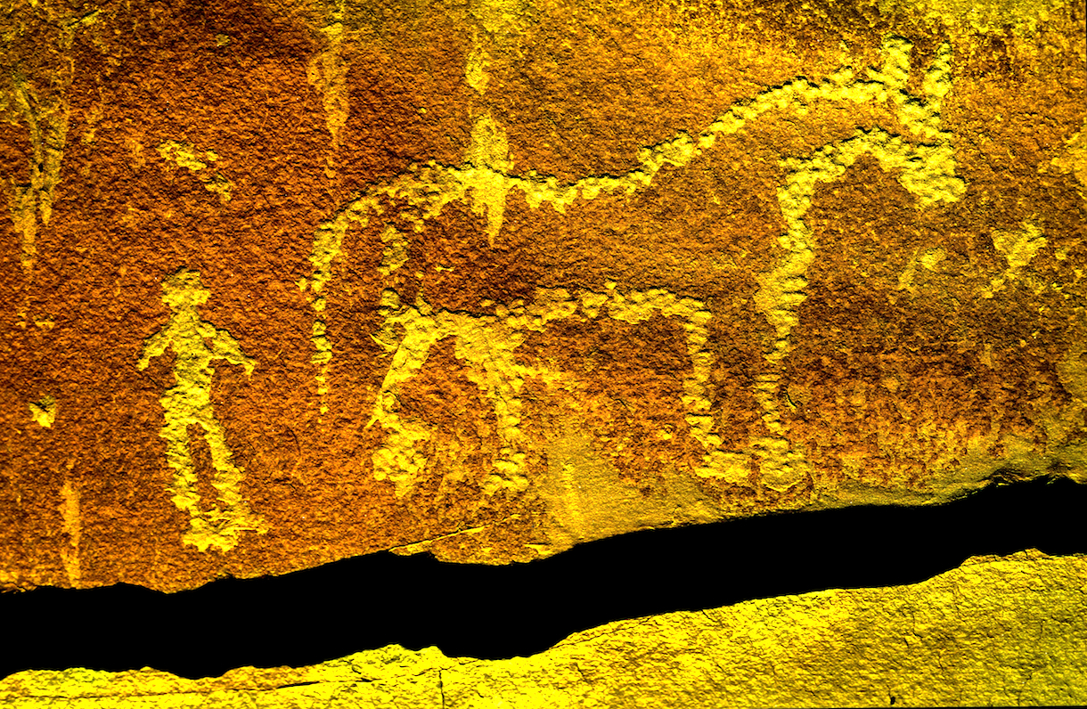
This rock art in southern Utah commemorates the first time the indian and the horse meet.
So eighty years before the Pilgrims landed at Plymouth Rock. Spanish Explorers visited Kansas: Francisco Vasquez de Coronado, seeking gold in New Mexico, was told of Quivera where “people’s pots and pans were beaten gold”. With 30 picked horsemen and a Franciscan Friar, Coronado marched “north by the needle” from the Texas panhandle until he reached Kansas. Here he found no gold, but a country he described as “the best I have ever seen for producing all the products of Spain.” The expedition entered present Kansas near Liberal and moved northeastward across the Arkansas River to what is now Rice and McPherson counties perhaps probing to present day Lawrence near the Kansas River before turning back. The guide, they called the Turk, confessed he had deceived the Spaniards and one night he went into his tent and the next morning when they broke camp he left only a dirt mound. He was strangled, buried and forgotten. For 25 days in the summer of 1541 the Turk had led Coronado among the grass-hut villages of the Quivira Indians, hoping to lose Coronado and men in the tall grass and waterless plains.

PECOS PUEBLO stood at the Cross Roads of the Great Plains and the Rio Grande Pueblo Communities.

Statue of the Conquistador Coronado stands next to a traffic circle in Liberal, Kansas near where the Spanish entered from Texas. JOHN MADSEN, BELOW
CORONADO AND QUIVIRA

The exact route that the Coronado Expedition took between Sonora and the Zuni Pueblos is currently unknown writes John Madsen, curator at the Arizona State Museum. He writes some have surmised that the trail led through Arizona, as far west as the Casa Grande Ruin, before turning northeast into the White Mountains region. Others, like historian Herbert E. Bolton, suggest a route along the San Pedro River, turning northeast below Benson, crossing the Gila River near Bylas, and passing near White River and Springerville before descending into the Zuni region. Madsen prefers the path similar to that proposed by archaeologist Carroll Riley. It traverses the country on what is now the Arizona–New Mexico state line, following the San Francisco River. Spanish accounts as early as 1747 reveal considerable use of the drainage by Zunis and Apaches. In 1795, Sonorans viewed the San Francisco River area as a potential trade route linking them with the Pueblo of Zuni and Santa Fe area pueblos like Pecos and Taos Pueblos.
Madsen teamed up with a Public Broadcast Station and launched a search for clues of where the Spanish had been targeting areas along their suspected route. Many historians and archaeologists along the route have tackled their piece of the mystery, many adding to the research, Madsen “had a hunch that the best source of information would come from the ranching communities along the Arizona–New Mexico border. These people know the land, and generations of family members have covered most of this dirt on horseback. The end result were 33 Spanish colonial period or Mexican historic artifacts like period spurs, coins, and horseshoes. Chain mail was take from a site in Kansas….more clues appeared.
Hartmann Map for Tracking the Expedition’s Route: Sleuthing for Clues and Artifacts

For over 100 years, the exact route of Coronado has been an American mystery. Generations of scholars have tried to retrace the steps of the army from their descriptions of villages, rivers, mountains, and native communities. National commissions have grappled with the problem of designating a “Coronado Trail” that tourists could follow, but clues were sparse, and politics raised its head when various factions tried to claim parts of the route for their state. Because we don’t know just where they were, it is tantalizingly hard to interpret the Coronado chronicles’ descriptions of native villages and other sites they visited.

GREENLEE COUNTY ARIZONA
Archaeologists William K.Hartmann, his wife Gayle and Richard Flint have worked tirelessly to sleuth out the route of the Coronado Expedition being guided by de Niza who the year before had seen Cibola from a distance. They found he might have followed the Rio Sonora to the river’s headwaters and then crossed the Cananea grasslands for four days past Arizape picking up the San Pedro River North turning east toward the Wilcox Playa North past present day Safford or the present day Sulfur Springs Valley crossing the Gila River cresting the Mogollon Rim past Point of Pines. William and Gayle Hartmann sees them moving east from the San Pedro, stopping at Turkey Creek in the Chiricahua’s then moving east through Apache Pass via Portal and into New Mexico and eventually into Texas. For more explanation visit their website….http://www.psi.edu/epo/coronado/coronadosjourney.html
WEST TURKEY CREEK, IN THE CHIRICAHUA MOUNTAIN RANGE, ONE PROPOSED STOP ALONG CORONADO’S ROUTE.
REPORTED DISCOVERY OF CHICHILTICALE The most exciting development is the apparent discovery of the long lost Coronado camp site at the Chichilticale New Mexican exploration geologist Nugent Brasher devoted several years to this problem. With brilliant deduction, mapping, and hard work, he began metal detecting surveys at several water-source sites he reported finding an iron cross bow point and other possible fragments from the Kuykendall ruin, a large pueblo ruin site at the foot of the Chiricahuas. The site appears definitely to be a the first Coronado camp site known in Arizona, and almost certainly is the Chichilticale ruin.
• ONGOING EXCAVATIONS AT CHICHILTICALE Brasher has set up a web site at www.chichilticale.com to record progress with the survey and excavations at the Chichilticale site. Excavations are continuing by Brasher and archaeologist Deni Seymour. Two more cross bow bolt heads have been shown on her web site that details excavation plans and progress, at http://www.seymourharlan.com/default.htm
• NEW BOOK FROM RICHARD FLINT In 2008, Richard Flint published a popular-level account of the expedition, “No Settlement No Conquest: A History of the Coronado Entrada,” a book that bids to replace Herbert Bolton’s volume as the best general account of the expedition.
• NEW BOOK FROM TONY HORWITZ In 2008, also, Pulitzer-prize winning journalist/writer Tony Horwitz dealt with the Coronado expedition as a major section of his book “A Voyage Long and Strange,” which is an account of the explorations in North America before the 1700s, adjusting and correcting some of the mythic tales that most American children learn about the initial European explorations of our continent.
Picked up by a local rancher In the 1960s and Little known for years, the Floydada gauntlet and some newly-found associated artifacts, such as odd-shaped metal arrow points, have recently been recognized as priceless relics of the Coronado army expedition.
THE JIMMY OWENS SITE IS LOCATED NEAR FLOYDADA ON THE TEXAS PANHANDLE SEE PICTURES OF COLONIAL SPANISH ARTIFACTS, SPURS, MESH GLOVE…
KIVA The Coronado Expedition to Tierra Nueva: The 1540–1542 Route across the Southwest by Richard Flint; Shirley Cushing Flint
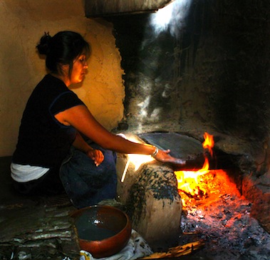
HOPI WOMEN have been making the ceremonial PIKI Bread for centuries in a special cooking space behind the main house

AFTERMATH of DE NIZA’S JOURNEY TO CIBOLA
Cultures, old as time, were attacked as pagan by the Catholic priests who accompanied the Conquistadors and who blessed their cruel attacks, in the name of saving pagan souls. The vanquished Indian was used as slaves, sold, slain or simply worked to death. The Cross, the symbol the Spanish brought the Indian and who adopted it, as pagans you can always use another God. Finally, the Spanish opened the West, the Conquistadors began the mapping of the West which became the United States of America’s quest for it’s “manifest destiny”. The American Indian, time and time again found himself in the way of the white man’s greed, the white men attacked the first Americans stealing their lands, their game and their lives, their homes, eventually they stole their children!
The facts show the journey of FRAY MARCUS de NIZA, a man of God, began an “era of extermination”, a period when approximately 20 million Indians inhabited this territory before the Conquest, and after just one century of Spanish rule there were only 1 million left! Many vanquished by Old World diseases brought to the New World with Europeans. The epidemics that broke out as well as the merciless workload imposed on the Indian dramatically diminished the Indian population. The scope of the epidemics over the years was tremendous, killing millions of people—in excess of 90% of the population in the hardest hit areas—and creating one of “the greatest human catastrophe in history, the most devastating disease was smallpox, but other deadly diseases included typhus, measles, influenza, bubonic plague, cholera, malaria, tuberculosis, mumps, yellow fever, and pertussis (whooping cough). The Americas also had a number of local diseases, such as tuberculosis and a type of syphilis, which soon went viral when taken back to the Old World.
“The moving multitude…darkened the whole plains,” wrote Lewis and Clark, who encountered a buffalo herd at South Dakota’s White River in 1806. With westward expansion of the American frontier, systematic reduction of the plains herds had began around 1830, when buffalo hunting became the chief industry of the plains, organized hunters killed buffalo for hides and meat, often killing 250 a day.

The White Man also almost exterminated the American Buffalo, herds said to be 20 miles wide and 20 miles deep, roaming the valleys they have always grazed, only a few small herds survive today. At that time, some white men sought to eradicate the buffalo to take away the Indian’s livelihood and well-being. Native American tribes depended on the buffalo’s meat and hides, and many still today believe the animal has special spiritual and healing powers, making it an important part of their culture. The railroads laying track across the plains further depleted the buffalo, as well as the Indian’s hunting grounds because hunting from train windows was widely advertised and passengers shot buffalo as they raced beside the trains. By 1883 both the northern and the southern herds had been destroyed. Less than 300 wild animals remained in the U.S. and Canada by the turn of the century out of the 30 to 75 million that was once thought to live there.
The Navajo “Long Walk” was the 1864 forced-deportation and some say attempted ethnic cleansing of the Navajo by the U.S. Government notes Wikipedia. The Navajos were forced to walk at gunpoint from their Arizona reservation to eastern New Mexico. Some 53 different forced marches occurred between August 1864 and the end of 1866. The “Trail of Tears” is a name given to the forced relocation and movement of Native American nations from southeastern parts of the United States Many of re-settled Indians suffered from exposure, disease and starvation on the way, many died, including 4,000 of the 15,000 relocated Cherokee. By 1837, 46,000 Native Americans from southeastern states had been removed from their homelands opening 25 million acres for predominantly white settlement.
SOUTHWESTPHOTOBANK’S PREHISTORY PHOTO GALLERIES CLICK HERE….
CONQUISTADOR ARMOUR BY ERIC THING
![]()
<a href=" SPANISH TRANSLATIONS:
RON BARBER WINS ARIZONA’S SECOND CONGRESSIONAL DISTRICT: ELECTION NIGHT BRINGS PRESIDENT OBAMA HOME WITH EXHALTATION AND SUDDEN DEATH FOR REPUBLICANS


RON BARBER HAS WON THE SOUTHERN ARIZONA HOUSE SEAT VACATED BY GABBY GIFFORD WITH A SLIM 2300 VOTE LEAD SAID THE AP. THE VOTE WAS CALLED WITH A NUMBER OF BALLOTS YET TO BE COUNTED.


VICTORIA STEEL AND HER SON NICK CELEBRATE HER TAKING 34.80% OR 42141 VOTES WITH ETHAN ORR GETTING 33.50% WITH 40542 VOTES WHILE MOHUR SARAH SIDHWA TOOK 31.40% OR 38064 VOTES.

Spectators at the University Marriott Hotel turned out for the Pima County Democrats Watch party and the evening was quiet until Obama brought home the Electorial College and sent the Republicans home early

HOPE IS THE AGENT OF CHANGE

COUNTY VOTE TALLIES COME IN SLOW AND STEADY


A WEEK AFTER THE ELECTION THE TOTAL COUNT IS STILL OUT ON THE RON BARBER VS MARTHA McSALLY RACE AND FINAL VOTE COUNTS ARE A WEEK OFF. TEAM BARBER HAS EXPRESSED CONFIDENCE FROM DAY ONE.


FORMER SURGEON GENERAL RICHARD CARMONA RECEIVED 942,427 VOTES OR 45.76% OF THE VOTE AND JEFF FLAKE, JEFF TOOK 1,023,493 VOTES OR RECEIVED 49.69%
MORE RON BARBER PHOTOS CLICK HERE

RICHARD CARMONA THANKS HIS CAMPAIGN STAFF FOR THEIR HARD FOUGHT BATTLE

INSPITE OF THE 929,422 DEMOCRATIC VOTES OR 43.96% OF THE VOTE IN ARIZONA GOING TO PRESIDENT OBAMA, GOVERNOR MITT ROMNEY GOT 1,141,974 VOTES TAKING 54.02% TO KEEP ARIZONA A RED STATE. STILL OBAMA CARRIED 332 ELECTORIAL VOTES OVER ROMNEY’S 206 SENDING REPUBLICANS TO BED EARLY.

AT THE END OF THE EVENING DEMOCRATS FIND PLENTY TO CELEBRATE AND DANCE THEIR WAY OUT THE DOOR
![]()
<a href=" SPANISH TRANSLATIONS:
TUCSON’S 2012 DAY OF THE DEAD PROCESSION DRAWS RECORD FAMILY CROWD TO DEADLY EVENT


CLICK HERE FOR SOUTHWESTPHOTOBANK DAY OF THE DEAD GALLERY FOR 2012
CLICK HERE FOR DAY OF THE DEAD GALLERY FOR 2011
CLICK HERE FOR DAY OF THE DEAD GALLERY FOR 2010</a
![]()
<a href=" SPANISH TRANSLATIONS:
KATERI TEKAKWITHA BATHS HER LOVE LIGHT ON THE WHITE DOVE OF THE DESERT ! SAN XAVIER MISSION

AZTEC DANCERS

THE TOHONO O’ODHAM SPIRIT RUNNERS FINISH THEIR PILGRIMAGE FOR KATERI TEKAKWITHA CARRYING HER CROSS TO HER CANONIZATION

KATERI TEKAKWITHA
“I KNOW SHE LISTENS TO US” inserts Loretta who said an Our Father and Hail Mary each Wednesday for years. Loretta was at the San Xavier Mission’s Celebration of the Canonization of the first Native American Saint Kateri Tekakwitha (KA’-tehr-ee teh-kuh-KWIH’-thuh). Loretta came and got a seat on the second row because of the love she inherited in 1960 from her mother who came to the San Xavier Mission and prayed regularly and she had brought Loretta along. When Loretta’s thyroid cancer reappeared after 25 years she had no fear because he loves Kateri, her life has been touched by the humble little girl who loved the Cross and fought her illness. “People here are praying for me, she says of her San Xavier Parish!” Known as the “Lily of the Mohawks,” Kateri was born in 1656 to a pagan Iroquois father and an Algonquin Christian mother. The daughter of a Mohawk chief and a Catholic Algonquin woman, Kateri was born in 1656 in Auriesville, about 40 miles (65 kilometers) northwest of Albany and in the heart of the Iroquois (EER’-uh-koy) Confederacy to which the Mohawks belong. Her parents and only brother died when she was 4 during a smallpox epidemic that left her badly scarred and with impaired eyesight. She went to live with her uncle, a Mohawk, and was baptized Catholic by Jesuit missionaries. She was ostracized and persecuted by others for her faith, and she died in Canada, when she was 24.

KATERI TEKAKWITHA AT SAN XAVIER
“May her example help us to live where we are, loving Jesus without denying who we are,” Pope Benedict said before 80,000 faithful. “Saint Kateri, protectress of Canada and the first Native American saint, we entrust you to the renewal of the faith in the first nations and in all of North America!” Spoke the Pope early this morning at Vatican City a sunrise away from the Sonoran Desert where the Tohono O’odam hosted their Celebration to Tekakwitha, where the Yaqui and Aztec Tribe Dancers escorted the procession of the Figurine that Blessed the People who Love Kateri and the Tohono O’odham “Spirited Runners” carried her Cross! San Xavier Mission was completed in 1797 by a work crew of Tohono O’odham Indian who built this Mission at a time when few structures anywhere rivaled its size or magnificent Spanish-colonial architecture. The Franciscan Order retains its original purpose of ministering to the religious needs of its parish and provides a Mission School to teach the Reservation’s kids.

DEACON ALFRED GONZALES SR. MINISTERS TO TOHONO OODHAM VILLAGES ON BOTH SIDES OF THE MEXICO-US BORDER.


FRIAR PONCE SERVES THE EAST SIDE OF THE TOHONO OoDHAM FROM TOPAWA
Franciscan Friar Steve Varnufsky finds the Canonization of Kateri is “a unifying figure” she has validated the faith of thousands of Native Americans who are Christians. Today, Varnufsky BELIEVES was a “Celebration of God’s Love” that was bringing together many tribes and nations. For Maria Orozzo who wore a Kateri Tekakwitha T-shirt knew this was very, very important and this rung true in her heart and enriched her spirit. For Miss Pasqua Yacqi Ariana Molina she believed Kateri’s canionization was something to celebrate and her friend, Junior Miss Paqua Yaqui Brandy Uriarte, said she “was very happy”.

MISS PASCA YAQUI ARIANA MOLINA (right) and BRANDY URIARTE JR MISS PASCUA YAQUI…
Father Ponce who ministers to the flock on the eastside of the enormous Tohono O’Odham Reservation said to a crowd of several hundred “We place her on the altar! We hold her up for all to see ! We witness to her Life !” “She stands before US as a mirror of GOD” “Saints come from somewhere ! Look around says Friar Ponce, waving his arms to the crowd, this is where Saints come from. Some day we hold them up to the Lord. “THIS IS THE DAY THE LORD HAS MADE”. Loretta agrees one night she continued, she was sick at home and unable to make her weekly pray trip to Kateria Tekakwitha, the cancer weighing on her mind, she began to pray and Kateri appeared before her eyes and her pain lessened and her saint disappeared with her prayers…

KATERI TEKAKWITHA HAS BEEN A PASSION FOR NATIVE AMERICANS THE NATION-WIDE AND FOR TWO DECADES THEY HAVE LOBBIED FOR THIS MOMENT……

KATERI IS A HERO OF THE YOUTH AND INSPIRES A NEW GENERATION
VATICAN CITY — Some 80,000 pilgrims in flowered lei, feathered headdresses and other traditional garb flooded St. Peter’s Square on Sunday as Pope Benedict XVI added seven more saints onto the roster of Catholic role models in a bid to reinvigorate the faith in parts of the world where it’s lagging. One of the new saints was American Kateri Tekakwitha, the first Native American saint from the U.S. Among the few people chosen to receive Communion from the pope himself was Jake Finkbonner, a 12-year-old boy of Native American descent from the western U.S. state of Washington, whose recovery from an infection of flesh-eating bacteria was deemed “miraculous” by the Vatican. The Vatican determined that Jake was cured through Kateri’s intercession after his family and community invoked her in their prayers, paving the way for her canonization.
Kateri was declared venerable by the Catholic Church in 1943 and she was Beatified in 1980. Hundreds of thousands have visited shrines to Kateri erected at both St. Francis Xavier and Caughnawaga and at her birth place at Auriesville, New York. Pilgrimages to these sites continue to celebrate the first Native American to be declared a Blessed. Her feast day is July 14. She is the patroness of the environment and ecology.

NAVAJO TACOS WERE SERVED TO ALL WHO ATTENDED THE CANONIATION CELEBRATION

TOHONO O’ODHAM GIRLS SIT TOGETHER AND GIGLE THROUGH THEIR MEAL.

KATERI TEKAKWITHA KNOWN FOR HER CHARITY, KINDNESS, LOVE AND HUMILITY

MANY OF THE SAN XAVIER PARISH ATTENDED

MOLLY SELESTINE AND DELPHINE ATONE FROM SAN SIMON ENJOY THE CORONATION OF SAINT KATERI TEKAKWITHA
COVERAGE OF TODAYS VATICAN CITY CANONIZATION OF THE SEVEN SAINTS
FOR MORE PHOTOS OF SAINT KATERI TEKAKWITHA
OCTOBER 27TH NPS INDIAN CULTURAL FESTIVAL AT THE SAGUARO WEST UNIT
![]()
<a href=" SPANISH TRANSLATIONS:
FALL COMES TO ARIZONA HIGHLANDS

An INDIAN SUMMER is gracing the Arizona highlands with shirt-sleeve days and low evening temperatures. Late rains have knocked the leaves from many of the Aspens in Flagstaff, Arizona but the annual pilgrimage of geese and ducks headed south from their cooler climes start each day at sunrise with loud honking and a spirited lift-off.

BORDER SECURITY FACT or FICTION ? MORE BOOTS ON THE BORDER NOW THAN EVER BEFORE ! SOME CALL FOR MILITIA, MARSHALL LAW TO STOP THE INVASION !


Following the shooting death of Robert Krentz along the US-Mexico Border residents ask government to protect their families, friends and homes.
IS AMERICA’S BORDER BROKEN?
US-Mexico Border Security in the 1970s was the key in Father Lambert Frembling’s pocket, it opened Mexico from the US and it opened the US from Mexico, it was the typical swinging gate for which US Customs had given him a key to the lock so he could shuttle between his flock as he held mass, funerals, baptisms and wedding in the small Tohono Oodham villages and outlaying chapels. Some of these small chapels were first started by Padre Kino or the early Spanish but today many are on Tohono O’odham Land that spans both sides of the US-Mexico Border.

Spent his life ministering to the Tohono O’odham on both sides of the US-Mexico Border.

The Tethered Aerostat Radar uses the aerostat as a stationary airborne platform for surveillance.

The Lochiel Arizona crossing was closed in 1983 due to budget retraints.

Vehicles with visas or Sonoran plates could access the area east of Nogales without going to Nogales first.

For decades the Naco, Az gate was this low tech relic of the 20th Century, since the National Border Industrial Complex has become fully engaged, billions of dollars have changed everything about the US-Mexico Border. At the new Naco Border Patrol Station numerous agents watch monitors showing folks in the darken rooms who and what is hanging out on the Border. If you drive past one, be friendly and wave.

The De La Ossa pioneer family settled on the US-Mexico Border from Spain and for generations they have ranched on both sides of the fence.

East of Nogales, AZ the Lochiel Gate was open from 10am to 4pm daily during the 1970-80’s allowing residents of Santa Cruz (headwaters of the river) Sonora access to the US and hospitals without going to Nogales first and then crossing.

MEXICO-US BORDER FENCE runs east from Lochiel and served as a geological border and each evening this fence was often cut and penetrated at will by smugglers, mules (men carrying backpacks of contraband) and coyotes (guides who escort undocumented crossers and either deliver their cargo or dump them in the desert.
 But in recent years Mexican Drug Cartels have militarized their approach to smuggling by hiring ex-military elite, who have trained load bearing drug smugglers to walk with a shotgun backing them up to negotiate any
First time I crossed at the Sasabe, I drove past the small shack on the US side and as I approached the Mexican one-room entry post I heard gun shots. Ahead of me standing in the entry lane my Mexican border agent was target-practicing while on duty. But as I approached he holstered his pistol and reloaded as I departed. On the US side, the small shack is now this lovely compound with all the 21st century Customs technology.

The US National Guard takes a forward operating position on Coronado Peak to Monitor smuggling routes to the east and illegal immigration toward the west. “They know we are here, says one Guard member, “we’re just a deterrent !” “They pay me $5000 a month to sit on a rock, for that kinda money I can do that all year-long.”

COPTERS, DRONES, SENSORS, RADAR PATROL THE LINE AS BULLDOZERS SCRAP THE BORDER CLEAN

This virtual fence watches more than 50 miles east and west of Sasabe, AZ

Tucson’s Tom Miller has written about Life along the U.S. Border for more than 30 years. Miller, a veteran of the underground press of the 1960s, has appeared in Smithsonian, The New Yorker, LIFE, The New York Times, Natural History, and many other publications. He wrote the introduction to Best Travel Writing – 2005, and has led educational tours through Cuba for the National Geographic Society and other organizations. His collection of some eighty versions of “La Bamba” led to his Rhino Records release, “The Best of La Bamba.” His book On the Border has been optioned by Productvision for a theatrical film.

After the shooting ranchers and residents of the four corners region of Southeast Arizona, Southwest New Mexico, and the Mexican States of Sonora and Chichuahua meet at the Apache, Arizona one room school house after Congress women Gabby Giffords brought in media from Tucson, Phoenix and the New York Times to hear the needs and concerns of these folk living on the Border. Before the meeting, everyone bowed their heads and paid tribute to their dead friend and fellow rancher Robert Krentz, who like themselves, had tried to make the best of this difficult situation and Krentz and his dog died trying.

Many residents complained to the Border Patrol that they had called and called, reported and reported and no one ever came. Congress Women Gabbie Giffords (far right) brought in media from Tucson and Phoenix “what good is Homeland Security if no one ever shows up when you need them”? Customs vehicles now carry this phone number 1-877-USBP-HELP painted on the back of all vehicles.
On Saturday, March 27th, 2010 the body of Robert Krentz, a longtime rancher, was found on his property near the border with Mexico on Saturday, March 27, 2010. Krentz and his dog were gunned down shortly after he reported spotting someone who appeared to be in trouble.

ROBERT KRENTZ
Today smugglers have moved off the flats and into the rugged mountain ranges where smugglers now carry their large backpacks and the crossers have moved further west onto the Tohono Oodham Reservation where the desert is less hospitable and where many unprepared for the desert have perished. Homeland Security has now deported more people this year than any year in the past decade. Homeland detained 212,000 in 2010, 120,000 in 2011 and less than 100,000 is expected to be picked up and detained in 2012. Death from failed summer crossing have dropped from 212 in July, 2010, 138 were reported in 2011 and in 2012 the numbers continues to drop but the proportion of those dying trying to cross into the U.S. continue to increase because of the increased difficulty. Border deaths were sparse throughout the 1990s. But in 2000, the numbers jumped drastically, increased border enforcement in California has moved migration routes east into some of Arizona’s most remote and inhospitable terrain. Unusually hot weather, even by Arizona standards, also may be contributing to the large number of deaths this year. Some migrants try to time their journeys to the summer monsoon season with its cooling rains, Kat Rodriguez told the Huffington Post. Rodriguez works with the human rights group Coalicion de Derechos Humanos who supply water stations in the desert to keep crossers alive who lack enough water to survive their journey. “The border experience 10 years ago is completely different than now,” Rodriguez said. (Today) “It’s brutal and ruthless.”
The 182 bodies of illegal border crossers recovered in fiscal year 2011 from New Mexico to Yuma County (the area within the Border Patrol’s Tucson Sector) are the fewest since fiscal 2002 when 147 bodies were found, indicates the Arizona Daily Star’s border death database.

WATER STATIONS are a political hot potato along the US-Mexico Borderlands but volunteers backing up southwest humanitarian groups walk a fine line helping out undocumented crossers and some have been arrested for their troubles. photo by Francisco Medina
Conservative critics of the water stations maintained by Tucson-based Coalicion de Derechos Humanos say the water stations enable “successful crossings” instead of “unsuccessful border crossings” where crossers are either picked up or turn themselves in to avoid death, or die in the desert. Conservatives say knowing the water is there encourage crossers to attempt the journey and without water stations–fewer people would attempt to cross the border–their deaths are their fault for trying and a deterrent to others attempting the trip. Some say many who cross have no idea of what lies before them, many are from the jungles of southern Mexico and South America, and have never seen a desert, let alone, crossed one.

Customs helicopter tracked these crossers, called in ground support and all where taken to holding pins where they await buses to take them back to the border.

Three Border Patrol agents guide 78 illegal immigrants through the desert near Arivaca after they were found when helicopter pilots followed fresh tire tracks to trees in wash where they were hiding. PHOTOS BY GARY GAYNOR

As the U.S. Customs and Border Protection continues to secure the border, the number of border crossings has declined dramatically in the last five years, the number of deaths has not decreased at the same pace. Human rights organizations say the increased militarization of the U.S.-Mexico border and the absence of government policy addressing the motivations that prompt migrants to cross, despite the dangers. “We never thought that we’d be in the business of helping to identify remains like in a war zone, and here we are,” said Isabel Garcia, co-chair and founder of the Coalicion de Derechos Humanos.  While the precise number of individuals crossing the U.S.-Mexico border without authorization is impossible to tally, Border Patrol’s apprehensions and death data offer the most accurate picture available. Each year the Border Patrol reports the number of bodies found along the Southwest border and the number of migrants that agents bring into custody. In 2011, 327,577 migrants attempted to cross the border illegally, down from 858,638 in 2007 — a nearly 62 percent drop. A close look at the numbers reveals that illegal border traffic has slowed and deaths have slightly declined, but the proportion of people dying in an attempt to cross has continued to rise. With no official record-keeping system, the exact number of illegal border crossers who died along Arizona’s stretch of U.S.-Mexican border will never be known. In the summer of 2004, the Arizona Daily Star in Tucson started compiling border deaths recorded by Pima, Cochise and Yuma County medical examiners in an effort to present an accurate tally of the numbers of people who die coming into the United States illegally through Southern Arizona. The Pima County Medical Examiner’s Office handles bodies found in Santa Cruz and Pinal Counties as well.
To report somebody who is missing who tried crossing the border through Arizona or for help trying to locate them, contact:
• Pima County Medical Examiner’s Office: 520-243-8600
• Mexican Consulate Call Center: 1-877-632-6678
• Coalición de Derechos Humanos: 520-770-1373
• National Missing and Unidentified Persons System website: http://www.namus.gov

This new wall was suck almost 10′ under ground to deter tunneling. With two months following its completion. Customs found two tunnels to parking spots on the US side, the driver of a car with a false bottom would park and go to lunch and when he returned. He had a fresh load of contraband for the drive home.

Traffic awaits their turn at customs at the DeConcini Border Crossing…
Even after he said it twice, Arizona Senator Lori Klein still insists “Joe the Plumber”– a.k.a. Sam Wurzelbacher — was “joking” about shooting people who illegally cross the U.S./Mexico border.”Put troops on the border, start shootin’;

Sam Wurzelbacher, aka Joe the Plumber

McCain has a 10 Point Plan to secure the southern Border…
 “With hundreds of thousands of people illegally crossing the border every year and record drug smuggling and violence, shouldn’t the government be working to completely secure the border? Our plan is a straightforward approach that will actually achieve a secure border.”
Senators McCain and Kyl’s Enhanced Ten Point Border Security Action Plan:
1) Deploy up to 6,000 National Guard troops to the United States-Mexico border.
2) Deploy 5,000 additional Border Patrol agents to the United States-Mexico border by 2016 and Offer Hardship Duty Pay to Border Patrol agents assigned to rural, high-trafficked areas. Provides funding for 500 more customs inspectors for the sw border.
3) Provide increased funding for Operation Streamline. A costly initiative aimed at criminally prosecuting and imprisoning every immigrant who crosses the U.S.-Mexico border unlawfully.
4) Provide increased funding for the Southwest Border Prosecutors Initiative. (Public Law 108-447) $30,000,000 is for the Southwest Border Prosecutor Initiative to reimburse State, county, parish, tribal, or municipal governments only for costs associated with the prosecution of criminal cases declined by local United States Attorneys offices.
5) Provide increased funding for Operation Stonegarden. “Operation Stonegarden grants direct critical funding to state, local and tribal law enforcement operations across the country,” The 2009 allocations reflects President Obama’s increased emphasis on the Southwest border in response to cartel violence along the U.S.-Mexico border. Based on greater risk, heavy cross-border traffic and border-related threat intelligence, nearly 76 percent of the $60 million Operation Stonegarden funds will go to Arizona, California, New Mexico and Texas—up from 59 percent in fiscal year 2008.
6) Construct double-layer fencing at needed locations along the United States-Mexico border and replace outdated and ineffective landing-mat fencing along the southwest border.
7) Increase the number of mobile and other surveillance systems and Unmanned Aerial Vehicles (UAVs) along the United States-Mexico border. Send additional fixed-wing aircraft and helicopters to the United States-Mexico border.
8) Provide funding for vital radio communications and interoperability between Customs and Border Patrol and state, local, and tribal law enforcement.
9) Provide funding for additional Border Patrol stations along the southwest border and explore the creation of an additional Border Patrol sector in Arizona. Create six more permanent Border Patrol Forward Operating Bases and upgrade existing bases.
10) Complete construction of the planned permanent checkpoint in Arizona. Deploy additional temporary roving checkpoints and increase horse patrols throughout the Tucson Sector.
All traffic from the US-Mexico Frontier is funneled through road check points scattered all over Southern Arizona. New roads has been graded parallel to the Border so Homeland Security is able to access the entire region rapidly.
THIS CONTROVERSIAL I-19 CHECK POINT HAS BEEN A SORE POINT WITH LOCAL RESIDENTS
DOUGLAS BORDER WALL
This new wall was installed in Nogales on the Arizona and Sonora line.
To help the country out the conservative left has tried to raise enough money to build a second border wall to backstop the present wall. One hysterical conservative fund initially raised $265,00 for the second wall, but six months later money for the project has dried up and the existing funds will not construct one mile of border wall. Still advocates say start the construction and more money will begin to flow in to preserve our democracy. The new wall just installed this year in Nogales is designed to halt a 10 ton truck going 40 mph. But it fails to keep out people who can quickly scale the fence, some fall and break bones but many more find a way over the wall. Every night border fence is cut and repaired the next day, critics say Mexican smugglers are able to cut the fence at its base bend it flat and use it as a ramp for trucks to enter the U.S., all in five minutes. The wall will not stop people unless you watch it and if you watch it–you don’t need a wall. One utube video shows two girls climbing the wall in less than 18 seconds! Is this really worth $4 million a mile ?
Presidential candidate Mitt Romney’s plans didn’t take notice of what’s already been done along the U.S-Mexico, including record-high staffing levels along the border and the failure of a Bush-era virtual-fence plan. Today the Border Patrol has more than 18,500 agents working on the southern border. In the year budget ending last September, agents apprehended about 340,000 illegal immigrants, the fewest in nearly 40 years – an average of 18 apprehensions per agent. The decrease in apprehensions has been linked to a weak economy producing fewer jobs in the U.S. and to more law-enforcement agents and technology being deployed along the border. Under the Bush administration, the government built hundreds of miles of fencing along the Mexican border. A planned virtual fence was also started, but was scrapped by the Obama administration in 2010 after the project was deemed a failure. About 53 miles of virtual fencing is in place near Sasabe, Az, at a cost of about $1 Billion. An exit-verification system has been sought since after the Sept. 11, 2001, terrorist attacks, but efforts to build one have been repeatedly stymied, most often because of the projected costs. Earlier this year, John Cohen, deputy counter terrorism coordinator for the Homeland Security Department, told a congressional panel that the agency was finalizing plans for a biometric data system to track who leaves the country and when. He didn’t give any details. Arizona’s unsuccessful Democratic candidate for Governor however does have some very specific ideas how best to secure the border…
“YOU WANT A CLOSED BORDER, HERE’S HOW BY FORMER ARIZONA ATTORNEY GENERAL TERRY GODDARD…
If the United States wants effective border security and not just a political punching bag, where symbolism trumps common sense, then more effective law‐enforcement measures must be taken. By attacking money laundering and making bi‐national criminal investigation and prosecution of the cartel bosses a priority, the border can be made significantly more secure. In the process, the mayhem in Mexico and the smuggling of drugs and people into the United States will be reduced. There must be a unified focus. All agencies must get on the same page to succeed. State and local law enforcement, with the coordinated efforts of all relevant federal agencies, can win this.</a>
<a href=”https://southwestphotojournal.com/wp-content/uploads/2012/10/terry-goddard.jpg”>
The United States’ southern border today bristles with technology and manpower designed to catch illegal immigrants and drug smugglers. Since 1986, the government has spent hundreds of billions of dollars on fences, aircraft, detention centers and agents. But even as federal budgets shrink and illegal immigration ebbs, experts say that there’s no end in sight for the growth of the border-industrial complex. A growing investment on the border stocked with equipment like Blackhawk helicopters — hundreds of aircraft fly daily missions — much of the southern border has grown into an industrial complex that is fed by the government and supplied by defense contractors and construction companies. The infrastructure includes a border fence that in some places has been built and rebuilt several times. And up to 25 miles north of the border, towers, sensors and permanent checkpoints spread across the landscape.
The government spends an estimated $5 million each day to house detainees awaiting deportation. All this takes manpower. Roughly 80,000 federal employees work in immigration enforcement and Homeland Security Secretary Janet Napolitano…believes it is safe to say that there has been more money, manpower, infrastructure technology, invested in the border protection mission in the last three years than ever before.
Hernan Lopez, a U.S. Border Patrol camera monitor watching our border with Mexico. Photo by Tricia McInroy
Janet Napolitano

Raul Grijalva

Politicans turned out to shake hands on Labor Day in Eloy, Az after the parade through downtown. The controversial Sheriff of Pinal County Paul Babeu shook hands with his constituents asking each for their vote. Babeu has recently drawn attention and criticism for his use of military equipment for a slush fund and was just told to return the equipment …
<a href=”http://www.statesman.com/news/news/opinion/longley-industry-of-border-security-creates-extra-/nRjsP/” title=”NATIONAL BORDER INDUSTRIAL COMPLEX” target=”_blank”>During the past 40 years, a multi-billion-dollar border industrial complex has sprouted up, bearing a striking resemblance to the military industrial complex that President Dwight Eisenhower warned about in 1960. These large institutions have a vested interest in short circuiting immigration reform and absorbing huge quantities of national security funds. What are the foundations of the complex? An obvious one is the private sector writes Kyle Longley, a history professor at Arizona State University
and the author of four books.

SASABE VIRTUAL FENCE
Many businesses long dependent on military spending have expanded into border security. The efforts of Boeing to build a high-tech fence along the border provide one example. It spent $1 billion of a proposed $8 billion budget before Homeland Security pulled the contract after Boeing produced only 53 miles of a flawed virtual fence. Not all businesses have defense industry ties. In fact, one of the biggest beneficiaries remains the private prison system. Huge companies, including Corrections Corporation and GEO Group, incarcerate large numbers of illegal immigrants for the government. Understanding the potential, the company’s lobbyists have backed hardline security-first leaders, such as Arizona Gov. Jan Brewer, who championed the Senate Bill 1070 immigration law. Many others in the private sector benefit, from airlines that rent planes to ICE to deport immigrants, to the local business people who provide food and gas to Border Patrol agents. It is a lucrative industry that ensures private businesses employ armies of lobbyists to push their agendas.

Lots of vehicles need lots of gas…

NICHOLAUS IVIE
The NICHOLAS IVIE, the U.S. Border Patrol agent killed in a shooting in Southern Arizona apparently opened fire on two fellow agents thinking they were armed smugglers and was killed when they returned fire, the head of the Border Patrol agents union said. The two sets of agents approached an area where a sensor had been activated early Tuesday from different directions and encountered each other in an area of heavy brush, National Border Patrol Council President George McCubbin told the Associated Press in Phoenix.”It’s happened and it’s a horrible tragedy for the agents involved and their families and the agency,” McCubbin said. “We can come up with some reasons as to how this happened, but that doesn’t fix anything. All we can do is send prayers to the families and all the agents involved that somehow they can find some peace with this someday.”Ivie’s death marked the first fatal shooting of an agent since a deadly 2010 firefight with Mexican bandits that killed U.S. Border Patrol Agent Brian Terry in December 2010 and spawned congressional probes of a botched government gun-smuggling investigation.
<a href=”http://channel.nationalgeographic.com/channel/videos/ultralight-drug-drop/embed/” title=”DRUG DROP” target=”_blank”>CLICK HERE TO SEE ULTRA-LIGHT AIRPLANE DROP HIS LOAD OF DRUGS…

Congress women Gabby Giffords shortly before being shot a a townhall meeting in Tucson Arizona, the Tucson lawmaker passed legislation making ultralight flights over the US-Mexico Border illegal. This new law handed local law enforcement a new weapon against illegal drug smuggling for border bound law enforcement agencies.
Just as the Bush administration launched the “global war against terrorism” and the wars in Iraq and Afghanistan in a burst of misguided patriotism, the administration also thrust us into a new era of “homeland” and border security with little reflection about costs and consequences. Without a clear and steady focus on the actual security threats, “homeland” and border security have devolved into wars against immigrants and drugs. Instead of prioritizing intelligence and interagency communication – the failures of which made 9/11 possible – the Bush administration, and now the Obama administration, have mounted security-rationalized crackdowns on the border and in the interior of the “homeland.”
As a result, the criminal justice system is overwhelmed, our prisons are crowded with immigrants and the flagging “war on drugs” has been given new life at home and abroad. Absent necessary strategic reflection and reform, the rush to achieve border security has bred dangerous insecurities about immigration and the integrity of our border.
Tightened control has made illegal crossings more difficult and more expensive. It has also turned what were previously routine, nonviolent crossings into dangerous undertakings that regularly involve dealings with criminal organizations. An indirect and certainly unintended consequence of the US border security buildup has been the increasingly violent competition between criminal organizations and gangs as they both struggle to maintain markets and trafficking corridors. Despite the border security buildups and $100 billion spent along the southwestern border, no terrorists or terrorist weapons have been seized. DHS does point out, however, that every year it regularly apprehends illegal border crossers from countries designated as state sponsors of terrorism. Those apprehended are mostly from Cuba, with single digit numbers from Iran, Syria, Sudan, Somalia, Pakistan, Afghanistan and Yemen. Border security hawks point to these arrests of citizens from “special interest countries” as evidence that the “broken border” keeps Americans vulnerable and that the border should be completely sealed.
Ten years after the federal government undertook a new commitment to domestic and border security, the nation deserves to know what the tens of millions of dollars spent on securing the southwestern border have accomplished. Before more tax dollars are dedicated to border security, we need new policy frameworks for immigration and illegal drugs that disaggregate these issues from homeland and national security.
The post-9/11 imperative of securing “the homeland” set off a widely played game of one-upmanship that has had Washington, border politicians and sheriffs, political activists and vigilantes competing to be regarded as the most serious and hawkish on border security. The emotions and concerns unleashed by the 9/11 attacks exacerbated the long-running practice of using the border security issue to further an array of political agendas – immigration crackdowns, border pork-barrel projects, drug wars, states’ rights and even liberal immigration reform.

BORDER PATROL AGENTS PICKUP LOCALS CROSSING OVER IN NOGALES AND RETURN THEM TO MEXICO
‘WHAT DOES A SECURE BORDER LOOK LIKE’ …. 2013 VIEW OF THE US-MEXICAN BORDER…CLICK HERE
US BORDER PATROL AGENT SHOOTS 14 YEAR OLD ROCK THROWER…CLICK HERE
UPDATE: MEXICAN DRUG WAR TURNS THE CORNER
ABANDONED BY SMUGGLERS, FORTUNE SMILES ON CROSSERS, BUT NOT ALWAYS
SONOYTA OVER RUN BY CRIMINALS, ARMY AND POLICE TAKE IT BACK
STAR ARTICLE DETAILS SONOYTA INVASION…CLICK HERE
US CONSULATE WARNS EXPATS IN ROCKY POINT
Nicholas Ivie, a 30-year-old father of two, was shot and killed in the sparse desert in SE ARIZONA
2013 BORDER APPREHENSIONS LOWEST IN ALMOST TWO DECADES….CLICK HERE
SOUTHWESTPHOTOBANK.COM PHOTO COLLECTION/GALLERIES ON THE US-MEXICO BORDER…CLICK HERE
![]()
<a href=" SPANISH TRANSLATIONS:
BIG SHOW JUST AROUND THE CORNER, ANNUAL FALL LEAVES STARTING EARLY IN FLAGSTAFF, WHITE MOUNTAINS LEAVES ON SCHEDULE BUT LATER


In the forest north of Greer AZ daisy’s have taken over the meadows and add a great splash of color in anticipation of the leaves changing colors.
Seems like the leaves are turning much earlier this year. Flagstaff might peak between October 10-17 while the White Mountains may better be viewed around the middle of October. The weather has been perfect– cool, but not freezing nights coupled with warm sunny days produce optimum leaf color. Aspen color is still spotty but should be showing well on the high trails this week and next in the FLAGSTAFF area and the annual colors are coming a little slower in the WHITE MOUNTAINS.  In the Alpine and Greer area nights have been 40 degrees with highs around 75 each day, the monsoon has ended and the afternoon rains have slowed. In short, the weather now is perfect. Time to enjoy the fall, the light has changed and now the days have begun to grow shorter by getting light later and the sun setting earlier, still the time to camp but it’s perfect campfire weather. Many of the White Mountain communities have festivals, cars shows, art exhibits, sales planned to attract flat-landers into the mountains for the annual exodus to escape the desert heat and see the golden leave change.
  Many a Sunday evening in October I-17 from Flagstaff to Phoenix is a sea of tail-lights as Phoenicians navigate bumper-to-bumper traffic all the way home from Flagstaff when the weather finally changes. Not all Phoenix tourists make it all of the way to Flagstaff or Williams, many are content to hang-out, in Sedona’s Oak Creek Canyon t
 here fall colors show itself closest to Phoenix, but that also means it is the most crowed and you have folks stepping all over you. At the peak Flagstaff’s Hart’s Prairie Road is the best drive to view the change and further east the Hanagan’s Meadow area south of Alpine, AZ will host many a nice view of Aspen golden glow.
37th Annual Fall Artisans Festival a Heritage Event – Mountain Meadow Recreation Complex, more than 80 arts and craft juried vendors, parade on Saturday at 10 am, $2, Sat 9 am – 6 pm, Sun 10 am – 3 pm, 928-367-4290 or 800-573-4031 or http://www.pinetoplakesidechamber.com
4th Annual Festival of Native American Culture in Sedona includes a special film night, Native American Invitational Art Show, entertainment, Archaeology Field Hikes, 928-567-0066 or http://www.festivalofnativeamericanculture.org
Celtic Harvest Festival Sedona – “A Celebration of the changing Light”
Sedona – Poco Diablo Resort Music, dance, master pipers, storytelling, Fairy Village for families, falcons, sheepdog herding demos, vendors, food, drink and more, $5-15, 9:30 am – 5:30 pm, http://www.celticharvestfestival.com/
6th Annual SalsaFest in Safford – Safford Town Square Sep 28 An opportunity to win prizes and bragging rights in the Salsa Challenge, live entertainment, food, salsa making contests, Festival Marketplace, Salsa music and dancing, food demos, chili roasting, kids area, and Jalapeno & Salsa eating competitions, kids’ corner with piñata bust, Fri 5-9 pm, includes a Salsa Glow, Hot Cars on the Salsa Trail, car show on Saturday, Sat. 9 am – 4 pm, 928-428-2511 or 888-837-1841 or http://www.SalsaTrail.com
Sep 29 6th Annual Prescott Pow Wow at Watson Lake Park, (3101 Watson Lake Rd, 86301), free, http://www.visit-prescott.com or http://prescottpowwow.wordpress.com or http://www.prescottpowwow.org/


Big Lake Arizona stands above 10,000 feet….
MORE WHITE MOUNTAIN PHOTOS ON SOUTHWESTPHOTOBANK GALLERIES….CLICK HERE
![]()
<a href=" SPANISH TRANSLATIONS:
VIVA! PROCLAIMS ELOY ARIZONA UPHOLDING A TRADITION OF FAMILY AS MEXICAN INDEPENDENCE DAY SEPTEMBER 16 SENDS RIPPLES WORLD-WIDE


IAN MASON LED THE PARADE DOWN THE ELOY MAIN STREET

ELOY’S HIGH SCHOOL DUST DEVIL MARCHING BAND ENTERTAINS THE CROWD.
Mexico is marking the 202nd anniversary of the “Grito de Dolores,” honoring the call to arms made by the priest Miguel Hidalgo in 1810 that began the struggle for independence from Spain, finally won in 1821. The Mexican War of Independence was an armed conflict between the people of Mexico and the Spanish colonial authorities, the movement was led by Mexican-born Spaniards, Mestizos and Amerindians who sought for their independence from Spain but their rebellion against their colonial masters and soon morphed into a national struggle for freedom. EVERY YEAR, on the 15th, at 11 pm the President of Mexico goes out on the central balcony of the Mexican National Palace, rings the bell (the same bell Hidalgo rang in 1810) and cries to the people gathered in the square below, who enthusiastically respond “¡Viva!”

THE MEXICAN FLAG IS A CAPE ON MEXICAN INDEPENDENCE DAY

JIM WALSH, COUNTY ATTORNEY, WAVES TO THE CROWD

RAMON ACUNA AND CELIA ACUNA MONTIJO
2012 FIESTA PETRIAS GRAND MARSHALL

DANCERS CHANGE COSTUMES BETWEEN PERFORMANCES

KEEPING THE TRADITIONS ALIVE

DANCERS HYDRATE BETWEEN DANCES.

SOME FOLKS COME EVERY YEAR
 There are rodeos, parades, bullfights, horseback rider performances and grand feasts. Statues in memory of Father Hidalgo are decorated with red, white, and green flowers. The Mexican Flag is made up of green, white, and red. The green represents hope, white is for unity, and red is for the blood of the national heroes. The crest in the center panel is Mexico’s coat of arms and portrays an eagle with a snake in its beak standing on a cactus.
After the parade, lots of folks stop by the Main Street Park and get something to eat from Ophelia’s whose Mexican food had the longest waiting line, they are either good or very slow ! The Mayor, vice-mayor, county official all spoke to the good people of Eloy, nationally known Sheriff Paul Babeu shook everyone’s hand and the padre blessed the crowd. High school mariachi bands groups serenaded the crowd, and the Amiga’s folkloric group prepared their charges to dance, all wearing blue tee-shirts with “Keeping Traditions Alive” printed on each back. Many of the young dancers scampered about the green grass, dressed in their long white slips–between costumes the girls frolicked until re-costumed. The older Eloy residents hung out beneath the shade of the mature trees covering the Main Street Park, the only green spot for miles in any direction, they had seen it all before and took the outing as an opportunity to catch up with folks they see less often.
Remember now if you’re not in Mexico, no matter where you are or what you’re doing, stop at 11 pm on September 15 and shout “¡Viva Mexico!” at the top of your lungs. Many voices will rise up and join you and you will be in good company, maybe, a hellva good party. Tequila! Please…!
MEXICO CITY INDEPENDENCE DAY PARADE …. CLICK
MORE SOUTHWESTPHOTOBANK PHOTOS FROM ELOY
![]()
<a href=" SPANISH TRANSLATIONS:
SOUTH WEST MONSOON WEATHER CAN CHANGE DRY WASHES TO RUN WET AND WILD IN MINUTES


Children learn important lessons about the destructive nature of water running loose after storms in the desert.

Power has been restored to all of the 20,000 folks left without cooling in the desert after the violent storm
It was a dark and stormy afternoon, more than 1000 lightning strikes were recorded when two brief but fierce storms blew through Tucson, the storms downed power lines and trees, produced flash flooding and prompted several swift-water rescues. Roads were closed for weeks following the 2 1/2 inches of rain that fell in 90 minutes all over Tucson. Hail as large as 1 inch in diameter fell in midtown, wind gusts reached 60 mph and Tucson Electric Power Co. crews worked overnight to restore power to about 20,000 customers in the Tucson area and 1,800 in Marana. Six power poles were left leaning or by Tucson Mall, one smashed the legendary golden arches sign at McDonald’s
 and eight power poles were down along Tangerine Road in Marana. The hardest-hit area was northwest Tucson, which got 1 1/2 to 2 1/4 inches of rain. The southwest side received between 1 and 2 inches of rainfall. Tucson Mall’s roof itself was reportedly damaged, but the extent was unreported. Law enforcement and firefighters responded to multiple calls of motorists in washes, one submerged vehicle at East River Road and North First Avenue. Officials with the Tucson Fire Department fielded 868 calls in a four-hour period Sunday. The Northwest Fire District dispatched firefighters to two swift-water rescues at a wash and a flooded intersection. No one was injured.
I lived next to this wash for 35 years and I have never seen it this deep before.

Running fast and furious at Flood stage

Kids play in the culvert that is fed from the Carmack Wash behind my house.
The Sunny South Western United States, is on the northern periphery of the North American Monsoon. Monsoon winds in the Southwest shift from a prevailing westerly or northwesterly direction in the winter and spring to a more southerly direction in the summer. The moisture comes from two sources: Southeast flow around high pressure in the upper atmosphere helps to transport middle and high-level moisture into the Southwest all the way from the Gulf of Mexico. Surface moisture arrives on a southerly flow out of the Gulf of California and the eastern Pacific Ocean. Combine these two moisture sources with daytime heating and upper disturbances and you have the ingredients for thunderstorms with heavy down pours, frequent lightning, strong winds and even dust storms known as haboobs.
In Tucson over the year, Pelicans from the Sea of Cortez in Mexico are frequently blown off course and end up in Tucson, surrounded by the Sonoran Desert where they are captured and taken to the Arizona-Sonoran Desert Museum until they get enough and then the whole brood is flown back home in Mexico. Happily due to recent rainfall, fire restrictions have been lifted in Coronado National Forest and Saguaro National Park. The restrictions banning campfires and smoking in both areas have been in effect since the beginning of June. Coronado National Forest visitors are encouraged to practice fire safety and not to leave a fire unattended unless it is “cold to the touch.” Campfires can be built only in designated areas in fire rings or grills in Saguaro National Park.

Don’t drive into Flooded Washes

Her male companion swam to safety but rescuers dropped this lady a line from the extended ladder of a fire truck so she could be pulled from her car.
Because of the frequent whitewater rescues that ensue after every monsoon storm the Arizona legislature passed the “Stupid Motorist Law”, which corresponds to section 28-910 of the Arizona Revised Statutes, and states that any motorist who becomes stranded after driving around barricades to enter a flooded stretch of roadway may be charged for the cost of their rescue. The need for this law came from the lack of storm sewers in the deserts of the Southwestern United States, combined with heavy rainfall in the desert, usually associated with the summer. This lack of adequate drainage leads to short-term flooding. Many desert cities and towns don’t use culverts to channel minor washes beneath the roadway. Only major washes and floodplains have bridges over them. Consequently, during rain storms, storm runoff flows over the roadway. During hard, strong rain storms, the washes, underpasses, and large storm drains can flow fast and deep enough to pick up an automobile and carry it downstream. During particularly strong floods, one might see a motorist stuck in the middle of a wash, sitting on the roof of a dead car submerged to the windows. In such cases, if public emergency services (such as a fire department, or paramedics) are called to rescue the motorist and tow the vehicle out of danger, the cost of those services can be billed to the motorist, up to a maximum of $2,000…

Kelly Brittle hangs on to the roll bar of his completely submerged pickup truck stranded in the middle of the Canyon del Oro Wash. Forty firefighters and rescue personnel worked for 90 minutes before Brittle was pulled from the rushing waters. The 35-year-old man was suffering from hypothermia and listed in stable condition following the rescue by white water rescuers who shot a rope across the scene and pulled Brittle from his submerged pickup.
Hikers need to head for high terrain and should check weather reports before heading into canyons, particularly slot canyons in Northern Arizona. More than a decade ago, this coming august, eleven people died in a slot in Antelope Canyon, AZ. The hiking guide was the only survivor, stripped bare of his clothes by the screaming speed of the water, completely covered in bruises and left temporarily blind by silt trapped under his eyelids, Francisco “Pancho” Quintana would be the only survivor of the flash flood. The rest of the victims drowned, and all but one of the recovered bodies were found in Lake Powell, miles downstream.

Rain falling miles away fill this normally dry wash raging bank to bank.
Kids playing in washes are at risk, motorist have been pulled from their vehicles and their bodies found miles downstream and some pulled from their vehicles in downtown Tucson have had their bodies recovered six months later when later storms removed all the sand and uncovers their bodies. About 75 percent of flash-flood deaths occur at night. Half of those victims die in automobiles. Many deaths occur when people drive around road barricades that clearly indicate that the road is gone.

For extensive information, resources and data about flooding in the U.S. from the National Weather Service visit http://www.srh.noaa.gov/rfcshare/ffg.php for General Flood Preparedness before a flood during spring and summer when rain fall can be heavy and can produce flash floods in a matter of hours. There are a few common sense preparations everyone can take to reduce their risks from harm and property destruction. The following lists steps everyone can take to prepare for any type of flood emergency:
Protect your self for driving safety in heavy rain fall take note six inches of water will reach the bottom of most passenger cars causing loss of control and possible stalling. A foot of water will float many vehicles. Two feet of rushing water can carry away most vehicles including sport utility vehicles and pick-ups. A local auto dealer parts house will make $30,000 after a heavy down pour because motorists often run too quickly through flooded washes pushing water up into the engine compartment and blasting a hole through the engine block. Drive slowly and carefully. Flash floods occur within six hours of the beginning of heavy rainfall.
FLASH FLOOD SAFETY RULES
Get out of areas subject to flooding, including dips, low spots, canyons, washes, etc.
Avoid already flooded and high velocity flow areas. Do NOT attempt to cross flowing streams.
If driving, remember the road may not exist under flood waters. Turn around and go another way. DO NOT drive through flooded roadways! You could be stranded or trapped.
If the vehicle stalls, leave it immediately and seek higher ground. Rapidly rising water can engulf your car and sweep it away. Remember, it’s better to be WET than DEAD! Be especially cautious at night when it is harder to see.
Do not camp or park your vehicle along streams or hike along washes, particularly during threatening weather.
Children should NEVER play around high water, storm drains, viaducts or arroyos.
Flash floods occur within a few minutes or hours of excessive rainfall. Flash floods can roll boulders, tear out trees, destroy buildings and bridges, and scour out new channels. Rapidly rising water can reach heights of 30 feet or more. Furthermore, flash-flood producing rains can trigger catastrophic mud slides. You will not always have a warning that these deadly, sudden floods are coming. Most flood deaths are due to FLASH FLOODS.
On July 16, 2012 The Arizona Republic-12 News Breaking News Team reported two people were injured after they were swept away by flash-flood waters at a stream near Sierra Vista just before 9 p.m., a 22-year-old man and 16-year-old girl were walking in the stream in the lower part of the Carr Canyon campground when a wall of water washed over them, says the Cochise County Sheriff’s Office. The water was from a torrential storm on the Huachuca Mountains. The man walked to a home along Carr Canyon Road and told the residents that he did not know what happened to the girl. The sheriff’s search and rescue team searched the area for the girl. Near morning, the Department of Public Safety helicopter found the girl on the north side of the wash less than a quarter of a mile downstream. Paramedics walked her out and treated her for mild hypothermia, cuts and bruises. The man was taken to the hospital and treated for cuts and bruises.
BE CAREFUL OUT THERE…
MORE MONSOON WEATHER PHOTOS AT SOUTHWESTPHOTOBANK.COM…CLICK HERE
![]()
<a href=" SPANISH TRANSLATIONS:
“ALL WE NEED IS A SPARK!” SEVERE FIRE SEASON PREDICTED IN U.S. SOUTH WEST: A FOREST OF “TORCHED TOOTHPICKS” WILL BE OUR LEGACY


South of Alpine, Az on Highway 191 last year’s Arizona-New Mexico Wallow Fire jumped the roadway in places and attacked old forest stands and roadsides…
Large wildfires raging out of control have become a summertime event in the South West United States during the past decade. As global warming has spread its accumulative affects upon the forests of the West, years of fire suppression allowing small trees to thicken forests and ground cover to grow, dry out and die becoming ready fuel for lightning strikes during the monsoon months. Mother natures cleansing affect on forests from annual fires have slowed due to intense fire suppression attempting to save homes built into the forest and large chunks of National Forests. Man-made fires, have become more and more commonplace as folks try to commune with nature and now find themselves running from it. This year’s Colorado Waldo Canyon fire, the worst in the state’s history turned deadly, killing two in its path as hot winds fan and push flame across fire breaks, highways and into residential subdivisions and endangered the U.S. Air Force Academy on the edge of Colorado Spring, Colorado. More than 32,000 residents have been evacuated and 346 homes were lost, that fire is now 77% contained and is being fought by 1500 firefighter from all over the Unites States. As this post is written, fires are being fought in most all the states of the American South West, the website http://www.inciweb.orgshows closures, containment, sat-maps and safety warnings. The site is being constantly updated by the boots on the ground at each and every fire showing assets involved in the fight for containment.
As Colorado residents were allowed to drive through their neighborhoods and glimpse their fire-attacked subdivisions, some found homes untouched, mail still in the mailbox and melted bowling balls, most however, found little they still recognized and now bears are moving from the forests and foraging through the city trash left behind by folks escaping the fires according to the Denver Post who issued the below multiple state round-up.

— Utah: Fire commanders say Utah’s largest wildfire has consumed more than 150 square miles and shows no sign of burning itself out. Hundreds of firefighters are trying to hold the Clay Springs fire from advancing on the ranching towns of Scipio and Mills on the edge of Utah’s west desert. The fire has destroyed one summer home and threatens 75 others. The fire was 48 percent contained on Sunday.
— Montana: Crews in eastern Montana strengthened fire lines overnight on a 246-square-mile complex of blazes burning about 10 miles west of Lame Deer. More than 500 firefighters are now at the lightning-caused fires that started Monday and have destroyed more than 30 structures.
— Wyoming: A wind-driven wildfire in a sparsely populated area of southeastern Wyoming exploded from eight square miles to nearly 58 square miles in a single day, and an unknown number of structures have burned. About 200 structures were considered threatened.
— Idaho: Firefighters in eastern Idaho had the 1,038-acre Charlotte fire 80 percent contained Sunday but remained cautious with a forecast of high winds and hot temperatures that could put hundreds of homes at risk.
— Colorado: The last evacuees from the High Park Fire in northern Colorado have been allowed to return home as crews fully contained the blaze. The 136-square-mile fire killed one resident and destroyed 259 houses, a state record until the fire near Colorado Springs.
-New Mexico: Baldy-Whitewater fires have burned out the heart of the Gila wilderness, both fires are lightning caused blazes in the New Mexico Gila Wilderness, the flames has grown together causing the worst forest fire in New Mexico’s history. More than ten per cent of the Gila has been lost to this blaze and experts say it will between 80-200 years before the damage from this fire is restored. Firefighter have been unable to get the upper hand on the blaze and expect to fight the blaze until the beginning of the monsoons. At present that fire is 87% contained.

At the top of Az State Road 191 lies the Mogollon Rim where the Blue Outlook looks over the entire state of Arizona into Mexico more than a 100 miles out. In early morning a hike there usually reflected a fantasy world where dwarfs and elves might hide in the trees and poke you as you pass. Today it’s gone.

In the early seventies, I fell in love with the Hannagan Meadow area in eastern Arizona. Old Forest stands blocked out the sky and sun, opening up to cienegas and large Aspen stands born from other fires, today much of that forest is gone, lost to the Wallow fire.

In Arizona, the Grapevine Fire began July lst from a monsoon caused lightning strike and is 10% contained and has blackened 14,000 acres and is being attacked by seven wildfire crews from all over southern Arizona. As the state moves into the 4th of July Holiday, fear mounts as campers retreat from the desert heat seeking cooler and higher altitudes and their increased presence increases the chance of careless or accidental fires. Arizona in the last decade, each year has broken state records for wildfires.

Smoke from the Rodeo-Chediski blaze in 2002 it fill the air all across the United States Midwest, affecting air quality for all residents.

The San Franciscan Peaks are constantly plagued by lightning strikes and man-made fires.

Harts Prairie Road showcases many Aspen stands which follow fires pretty closely after a Ponderoso Pine forest is wiped out, Aspen quickly replace the old stand.
On going research from Northern Arizona University suggests wildfires may cause soils to release large amounts of greenhouse gas that could potentially speed up climate change. Some researchers are blaming massive wildfire on overgrown forests. Four of the worst fires in Arizona have happened in the last ten years, and the head of the U.S. Forest service says to expect more fires like that across the West.

Driving south AZSR260 toward Big Lake, AZ motorists can view the impact of the 2011 Wallow Fire now Arizona’s largest fire on record, claiming 800 square miles.

Rodeo Fire near Show Low, Az June 28, 2002

Fire assets constantly land and take off during the fight to control last year’s blaze.
While the Wallow Fire was stealing headlines from every blaze in the South West of the United States, Southern Arizona had two smaller but huge on their own scale burning at the same time. The man-caused HorseShoe2 Fire in Southeast Arizona’s Chiricahua Mountain Range was burning 223,000 acres and further west near Sierra Vista, Az the Monument Fire burned 22 homes through some canyon subdivisions evacuating folks from their homes while firefighter tried to defend the timberline homes.
Chiricahua HorseShoe2 Fire

On Sierra Vista, Az southeast side Evacuees from the Monument Fire set up camp outside a shopping center to hang with friends and wait until they could return home.

Lining the northside of the Pinery Canyon Road leading up canyon toward Rustler’s Roost Campground now closed due to heavy fire damage to the Chiricahua forest.
The Chiricahua Mountain Range in Southeast Arizona, were hit pretty hard by the HorseShoe2 Fire reports Christopher Guiterman PhD student in the School of Natural Resources and the Environment Laboratory of Tree-Ring Research.

Photo by Chris Guiterman

Julio Robertson uses a chainsaw to clear a fence line destroyed by falling timber near the summitt of the Pinery Canyon Road. This fence kept cattle and wildlife from the road and off the canyons steeps slopes.

This Turkey Creek historic home was wiped out stream side but the mosaic blaze missed other homes in the same area. Aerial seeding has covered the hillsides to get roots in the ground to prevent additional flood damage.
Two Tree Ring Studies from the University of Arizona Tree Ring Laboratory show centuries of fire history, one demonstrated from 1700 up to 1866, tree rings in the Chiricahua Range saw fires in these canyons, forest and grasslands burning every four to eight years showing the essential character of fire function to reduce catastropic fire risk and ultimately restored those systems to a more productive, diverse and sustainable ecology.

BURNS IN THE CHIRICAHUA’S FREQUENTLY BEGIN IN THE GRASSLANDS AND BURN THROUGH A SINGLE CANYON REACHING THE PONDEROSA PINES ON THE MOUNTAIN’S RIDGELNE

THE CHIRICAHUA PONDEROSA PINE FOREST BURNS
LIST OF WORLD’S LARGEST WILDFIRES FROM WIKIPEDIA…CLICK HERE
TREE RING STUDIES: FIRE HISTORY IN THE GALLERY PINE-OAKS FORESTS OF ADJACENT GRASSLANDS OF THE CHIRICAHUA MOUNTAINS OF ARIZONA by Mark Kaib, Christopher Baisan, Heurid Grissino-Maer and Thomas W. Swetnam.
FIRE HISTORY IN A MEXICAN OAK-PINE WOODLAND AND ADJACENT MONTANE CONIFER GALLERY FOREST IN SOUTHEAST ARIZONA by Thomas W. Swetnam, Christopher Baisano, Anthony Caprio and Peter Brown.

The Aspen Fire burned in 2003 for about a month on Mount Lemmon 9,000 feet above Tucson. It burned 84,750 acres and destroyed 340 homes and businesses in the town of Summerhaven,AZ
A total of 121,000 acres of the Coronado National Forest 250,000-acre Santa Catalina Ranger District burned in just two years. The Bullock fire was out in mid-June 2002, it had raged across 36,000 acres of prime timber and grasslands.Firefighters were able to douse it after a favorable shift of winds and breaks created by Catalina Highway and the Control Road down the north side of the mountains to Oracle. The Aspen Fire burned from June 17, 2003 for about a month on Mount Lemmon. It burned 84,750 acres of land, and destroyed 340 homes and businesses in the town of Summerhaven.

After two fire season’s back to back the mountain has been blackened and today is a shadow of its former self.

WHAT’S LEFT AFTER FIRE CAUSED FLOOD RIPPED APART THIS CANYON

This pastoral scene was once found in Catalina State Park on the west side of the Santa Catalina Range. Hikers would go for a hike and head for this stream for picnics, outings with kids, girlfriends or family. One night after the fires a wall of water 15 feet high and 50 feet across washed and scoured out this canyon tossing aside boulder the size of my living room. The next day this spot was gone and I haven’t been back since.
WHAT’S LEFT AFTER A FLOOD RIPPED APART THIS CANYON
NATIONAL GUARD FIREFIGHTERS DIE WHEN PLANE CRASHES FIGHTING SOUTH DAKOTA BLAZE…..CLICK HERE
SOUTHWEST PHOTOBANK GALLERIES OF A DECADE OF FIRE AFTERMATH IN ARIZONA…..CLICK HERE
WESTERN WILDFIRE RECOVERY: In New Mexico, the Santa Clara Pueblo is seeking volunteers to fill sandbags for fear the American Indian village of 3,100 will be washed away by runoff from mountainsides left denuded by a blaze last year. Read more about Western wildfire recovery likely to take years
UPDATE: Two cousins who pleaded guilty to starting the largest wildfire in Arizona history were sentenced Wednesday to 48 hours in jail and 200 hours of community service. Their still smoldering campfire sparked the Wallow Fire, which ultimately consumed 32 homes, four businesses and more than 30 barns and other buildings during the six weeks it burned out of control in the Apache National Forest last summer.
![]()
<a href=" SPANISH TRANSLATIONS:
“THAT SPOT IS NOT THAT SCENIC!” BUILDING ROSEMONT MINE: EARNING THE PUBLIC TRUST! SELLING ARIZONA’S NEXT OPEN PIT MINE


It is unfortunate that it wasn’t explained to these people that it didn’t really matter what they had to say. The Rosemont Copper Mine is a done deal and the people of Tucson and Southern Arizona have been misled.
/>< The Rosemont Mine Project will sink a mile deep open pit copper mine on the South West side of Tucson.

Multiple images of the projected mine site stitched together…

Imagine this hole-in-the-ground at the Santa Rita panarama above !

An enormous overburden must be removed and stacked as tailing before the copper ore concentration is reached.
Southern Arizona is at a crossroads. Globalization has a bulls-eye on Arizona’s quality of life, Asian rim companies are screaming for copper and China is locking up existing supply to assure themselves of the minerals they will need to grow their rapidly expanding economy. Meanwhile gold and copper mining stock is the perfect long-term hedge against inflation and a shaky stock market so resort towns, retirement communities and cities in a dozen states have mines starting up with five miles of many communities. In southern Arizona alone, within five miles of each city, like Tucson, it has 1,741 claims. Green Valley has 864 claims, Tombstone has 451, Sierra Vista has 102, Sonoita has 43, Bisbee 114, Rio Rico 31, Tumacacori 21, Tubac has 18 claims within five miles of each Arizona town. By comparison, Phoenix has 5131 claims within five miles of the Greater Metropolitan area. Mining companies know political change is in air and if they don’t grandfather in their claims to the 1872 mining law, which gives them acres of land at $5 an acre to crush and pulverize tons of ore to find enough gold to make a single gold ring. The 1872 Mining Law is an antiquated piece of legislation which has been attacked each congress and will change as soon as the votes arrive….most investors want to see who will win the November election.
As metals prices rise, it is likely that many of these claims will be developed into mines, fueled by the nation’s antiquated 1872 Mining Law, which does not provide citizens or government officials any way to stop a mine from being developed on any valid claims, short of buying out the claim or direct intervention by the Secretary of the Interior, a very rare event. And a buyout assumes the claim holder wants to sell.
Meanwhile most existing southern Arizona mines, both large and small, continue to explore around Southern Arizona, sampling, testing old claims and watching, waiting to see what happens to Rosemont Copper’s bid to build a open pit along a scenic highway and tap a phantom water source. Southern Arizona alone has 3000 claims and once Rosemont shovels are in the ground, developing other claims will be a slam dunk by expanding the overall mine complex presently planned for four square miles. Several other mines are watching how the Rosemont experience unfolds. Soon the rush for mineral rights in Southern Arizona will make the 49 Gold Rush look silly in comparison with the $Billions of copper and silver, gold that will reward its owner, not U.S. citizens, but foreign mining companies who will mine out this land, take our mineral wealth, ship it to China and sell it back to us…fivefold the price. When they leave, their mess will be our problem forever. The upside is where?
Where miners have scratched Arizona soil they have found a rich mineral soil full of gold, silver and copper, and other rare earth minerals needed now for electronics, like plasma TV’s–the entire Pacific Rim has Arizona Copper Mines cranking up to extract low grade ores for big dollar returns, jobs are being created and the trickle down economy will benefit us all we are told. The first copper mine creation in 65 years is happening in Safford.
Southeast of Tucson the Rosemont Mine Complex, plans to open a new pit in the foothills of the Santa Rita Mountains, that plan has been controversial.

Opposition to Rosemont Copper at a Green Valley hearing where residents turned out to speak and to listen as Tohonon Oodham Chairman Ed Norris and Pima County’s County Manager Chuck Huckelberry, along with spokesmen from Rio Rico, Tubac, Sahuarita all who stood against the mine.

The rolling foothills of the Santa Rita range lie 30 miles southeast of Tucson where residents are fighting for their lifestyle but business says we need jobs. Neither seem concerned about future impacts on groundwater, future growth and present Tucson homeowners.

Cresting the hill this Santa Rita Mountain view unfolds into this winter wonderland south east of Tucson and in the four square mile footprint of the soon to be constructed Rosemont Mine Complex.
The Santa Rita Mountains is one of Arizona’s top Treasures. Mount Wrightson is the highest point around Tucson at an elevation of 9,453 feet. One snowy morning I remember winding up State Route 83 cresting the ridge and a snowy winter scene unfolded with a heavy frosting of snow on Mount Wrightson which towers 7,000 feet above southern Arizona. That was a magic morning and I love the memory, drinking in the raw, untouched flavor of that scene, it is inconceivable to see that land now churned up, mined for its minerals and cast aside as mine tailing. It’s pristine-in part–because it is forest land, set aside and protected-but since the 1872 Mining Law, U.S. Citizens (read-corporations) are allowed to extract the mineral wealth from any land.  The Rosemont Copper Project has slowly but surely navigated through the needed permits and studies– each contentious step –one step closer to building an open pit mine on one of Arizona’s Scenic Highways. Over last few years, Tucsonans have come down on one side or the other–“that spot is not that scenic”, a local banker told me when asked where he stood on building the mine.

Speaking to the Democrats of Oro Valley, community activitist Gayle Hartmann gives an overview of the Rosemont Project, and efforts to curb the proposed mine by the Save the Santa Rita Environmental Group.
Meanwhile, huge crowds have turned out in the permitting process to protest what they saw as an attack on their way of life. These are the people of Elgin, Sonoita, Sahuarita and Green Valley, including Charles Huckelberry, Pima’s county manager and Ed Norris, Chairman of the Tohono O’odham people both who represent large parts of southern Arizona. To counter, Rosemont sponsored the Tour of Tucson Bike Race one year and yet another it sponsored the epic 24 Hours in the Old Pueblo Mountain Bike Race all in hopes of raising it’s “environmental” image and trying to fit into the Tucson community by spreading cash among many community support groups. Most recently Rosemont complained about the slow process (they hoped to be in construction by now) and complained the Pima County permitting process was biased and intentionally derailing their timeline and progress. They told the Feds they would appeal to Arizona’s Dept of Environmental Quality! Given ADEQ’s record of assists in Hayden for ASARCO, there is little doubt, their appeal will move forward and eventually be approved.
THE 1872 MINING LAW IS OUTDATED AND IN SERIOUS NEED OF REVIEW….

The first ore taken from the Morenci Mine were 80 per cent pure. The above Morenci photo was taken during a 1980’s Bust Cycle when everyone was fired and equipment idled waiting for the return of favorable copper prices. Rosemont Mine projects it will spend $900 million to build the Rosemont Complex and that is the same $900 million that will be required to clean up Clifton/Morenci after 162 years of toxic hardrock mining. Phelps Dodge was ordered to spend $1Billion to clean up the smelter in El Paso, opponents of the settlement say PD got off with pennies on the dollar and not a penny goes across the border to folks downwind for 100 years.< Does anyone really think Rosemont will be around when cleanup is needed. Historically, a property sells to someone who goes bankrupt and the taxpayer pays for the mess.
No one can anticipate Acts of God, Karma is always a big factor. So in 1979 when an earthen dam breached and spilled 1,100 tons of radioactive mill wastes and 90 million gallons of contaminated water into a tributary of the Little Colorado River or in 1984, when a flash flood washed tons of high grade uranium ore from Hack Canyon Mine into Kanab Creek. The Grand Canyon’s Orphan Mine still continues to contaminate creeks, it produced 4.3 million pounds of some of the purest uranium ever found in the U.S. before closing in 1969. The Orphan Mine was declared a Superfund site by the EPA. The National Park Service warns backpackers along the Tonto Trail not to use water from either drainage. Another spill 30 years ago, occurred on July 19, 1979 when an earthen tailing dam near the United Nuclear Church Rock Uranium mine collapsed, spilling 90 million gallons of liquid radioactive waste and 1100 tons of solid mill wastes into the Rio Puerco River. The spill contaminated water, land and air at least 50 miles downstream into New Mexico and Arizona. It is believed more radiation was released in that spill than at the Three Mile Island nuclear accident, making the Church Rock spill a Superfund site and the largest release of radioactive waste ever in the U.S..
Spills happen and the Nuclear Regulatory Commission acknowledges that many toxic tailing have been washed into our region’s waterways and collectively, these events have documented risks and offer harm to people’s health. Drive through any Arizona copper town which are blighted and personal property values decline dramatically. If no drinking water is found outside grocery stores or water stations good luck selling your house. The Central Arizona Project taps the Colorado River which provides 26 million people throughout the Southwest with drinking water. Last year, Lake Mead water levels stood within 50 feet of water restrictions which will hit Tucson first, hit Las Vegas hardest and be a major inconvenience to California. Rosemont Mine lies at the end of that pipeline. Green Valley groundwater levels already suffering with an annual water deficit withdraw without adding another copper mine which takes the same water that another 25,000 residents need. Population growth will easily fulfill that need, and all water use adds up and it is a finite resource. Rosemont proposes to recharge the aquifer from various sources and the newest estimates are the Rio Colorado could be dry by 2020.

CAP Canal ends across the road from the Tohono Oodham San Xavier District next to the Copper Tailing from the ASARCO Mission Mine.
“Strong demand for growth out of China, India, Brazil and Russia, with a struggling supply response”, was the all the motivation needed for Wildcat Silver Corporation, a Canadian-based mining company, to step up their Patagonia exploration. Wildcat wants to conduct extensive exploratory drilling on Forest land near Patagonia to map out a plan to construct an open-pit mine near Harshaw. Wildcat’s Hermosa project, also called the Hardshell project, involves an area six miles east of Patagonia along the Harshaw Road. The Wildcat Silver Corporation could bring in $99 million annually in profits if it gets state and federal approval. Wildcat will spend $337 million to build the project. Each year for 18 years, the mine plans to mine 4.1 million ounces of silver, about 256,000 tons of a manganese compound, about 22,200 tons of zinc and about 1,050 tons of copper from Southern Arizona.
HERMOSA PROJECT THREATENS PATAGONIA WATER SUPPLY….CLICK HERE

Harshaw was a large community with a large Catholic Church
this was the Harshaw Mill in 1879
Wildcat will dig a 600-foot-deep open pit, and then mine at least 1,800 feet underground to collect minerals too deep for the pit. The mine’s water needs will dramatically draw on the aquifer pulling down 720,000 gallons of groundwater daily. Large ore trucks will dramatically change driving up and down the Harshaw Road, a narrow winding mountain road winding through Scrub Oak, Juniper Forest which has access to the old mining towns left behind the last time this good idea went bad. Patagonia folks sound scared. Few say jobs, most say goodbye to their way of life., Patagonia was once called “Arizona’s best kept secret”, the village’s residents believe what they know now, will be no longer……
The Tombstone Exploration Company holds the largest chunk, 11,863 acres, of Tombstone’s historical mining District. In March TEC received approval for State Exploration Permits for minerals, including gold, silver and copper in the eastern edge of the Tombstone, the additional permits, approved, doubles their existing holdings. Study of the mineral content of the Tombstone Mining District show a wide assortment of mineralization including silver, gold, copper, lead, and zinc minerals, along with manganese, tellurium, molybdenum, and vanadium. Although Tombstone is famous for bonanza silver deposits it is essentially a precious-metal district. Alan Brown, President of Tombstone, states, “With prices for metals at historic high levels, the time to move aggressively forward is now. We are currently planning exploration and a drill program for the Zebra property.”

BISBEE HAD A OPEN PIT IN THE CENTER OF THE COMMUNITY FOR OVER A 100 YEARS. WE CAN TAKE GUIDED TOURS OF THE OPEN PIT TODAY, SOME SUGGESTIONS FOR THE PIT INCLUDED FLOODING AND GO WATER SKIING…
Further down the Harshaw Road a large group of mines with over 80 existing claims covering 1,600 acres extends beyond Washington, Az on the north and to about a mile west and southwest of Duquesne, Az on the south. It is owned chiefly by the Duquesne Mining & Reduction Co. of Pittsburgh, PA, with local headquarters at Duquesne, and the reduction plant at Washington. Duquesne and Washington Camp were once thriving mining camps and at one point both were busy places, now they are ghost towns.
The Johnson Camp Mine in Cochise County
The Johnson Camp property is 65 miles east of Tucson in Cochise County. The Johnson Camp mine, is an open pit copper mine and production facility using solvent extraction. Johnson Camp includes two existing open pits, the Burro and Copper Chief bulk mining pits which are expected to produce 25 million pounds of copper cathodes annually over a mine life of 13 years. Recently it idled to build a new leaching facility but hopes to mine in 2012.
Wildcat Silver recently withdrew a contested request for 15 exploratory drill holes, saying they now wish to drill 176 exploratory holes on claims on public land in the Patagonia Mountains.

HARSHAW CREEK DRILL AREA
The corporation needs to map the silver content lying underneath nine square miles of Shrub Oak Woodlands. The corporation has recently doubled it estimates from 123 million ounces to 271 million for the future Hermosa Mine which is expected to be in the top 25% of all silver mines in the world.
At its peak in the 1880s and 1890s, Harshaw’s was once considered scenic, it was surrounded by oak forests, lush pastures, and had enough pure mountain water to run the mill and work the ore. Today, Harshaw Creek is lined with sycamores, cottonwoods, and willows which are typical foliage in more arid riparian zones. While Harshaw Creek still flows, they are no longer as pure as a 100 years ago. Recent water studies according to Wikipedia have found high levels of copper and zinc, as well as high acidity in the creek. While many factors contribute to this pollution, mining and milling residue from waste dumps are the most significant source. The abandoned Endless Chain Mine, near the headwaters of Harshaw Creek, is one of the biggest contributing factors to the pollution.
Are we heading down a path we might regret in the future?” YES, is the obvious answer! Is there anything we can do about it? NO, once a valid claim is made there is no legal authority to stop it. Mining law elevates mining above all other uses of federal land and contains no environmental protection.
Tucson will have a new open pit, Hwy 83 beloved for its drive in the countryside winding through the mountain pass opening up to the Santa Rita foothills, will be changed forever. This is no small price that Southern Arizona is paying, this is a crown jewel, and it will not stop here. If we don’t throw out the carpetbaggers who sell their vote to big corporations allegedly for support, this will never stop, in fact get used to it-this is just the beginning.

This ASARCO Mine lies in the foothills of the Silverbell Mountains and shows by example how a mine in the Santa Rita Foothills would change the land forever.
MORE COPPER COUNTRY PHOTOS SEE SOUTHWEST PHOTOBANK GALLERY … CLICK HERE
ARIZONA BOUGHT AND PAID OFF FOR $10 MILLION, MINE MOVES ONE STEP CLOSER……CLICK HERE
SEATTLE TIMES INVESTIGATIVE STORY ON THE LEGACY OF THE 1872 MINING LAW
ARIZONA COMMUNITIES THREATENED BY MINING LAW
ROSEMONT COPPER TO RUN OUT OF CASH BY YEARS END?
SEATTLE TIMES STUDY OF THE LEGACY OF THE 1872 MINING LAW TO THE AMERICAN SOUTHWEST
Arizona Daily Star article on reopening the Oracle Ridge Mine confused and muddled…click here
ARIZONA ADQ TAKES JURISDICTION FROM PIMA COUNTY FAST TRACKS ROSEMONT AIR PERMIT…CLICK HERE
Interesting Map of all Copper Sources in Central Arizona…click here
![]()
<a href=” SPANISH TRANSLATIONS:">


